Ridley Creek State Park
| Ridley Creek State Park | |
|---|---|
| Pennsylvania State Park | |
| Natural Monument (IUCN III) | |
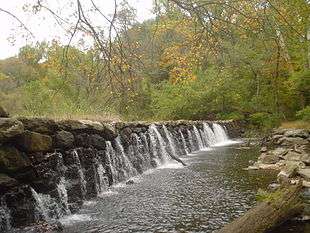
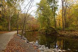 Ridley Creek as seen on an autumn day | |
| Country | United States |
| State | Pennsylvania |
| County | Delaware |
| Townships | Edgmont, Middletown, Upper Providence |
| Location | [1] |
| - coordinates | 39°57′21″N 75°26′59″W / 39.95583°N 75.44972°WCoordinates: 39°57′21″N 75°26′59″W / 39.95583°N 75.44972°W |
| - elevation | 315 ft (96 m) [1] |
| Area | 2,606 acres (1,055 ha) [2] |
| Founded | August 1972 |
| Managed by | Pennsylvania Department of Conservation and Natural Resources |
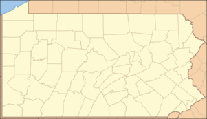 Location of Ridley Creek State Park in Pennsylvania | |
| Website : Ridley Creek State Park | |
Ridley Creek State Park is a 2,606-acre (1,055 ha) Pennsylvania state park in Edgmont, Middletown and Upper Providence Townships, Delaware County, Pennsylvania in the United States. The park, about 5 miles (8 km) north of the county seat of Media, offers many recreational activities, such as hiking, biking, fishing, and picnicking. Ridley Creek passes through the park. Highlights include a 5-mile (8 km) paved multi-use trail, a formal garden designed by the Olmsted Brothers, and Colonial Pennsylvania Plantation, which recreates daily life on a pre-Revolutionary farm. The park is adjacent to the John J. Tyler Arboretum. Ridley Creek State Park is just over 16 miles (26 km) from downtown, Philadelphia between Pennsylvania Route 352 and Pennsylvania Route 252 on Gradyville Road.
History
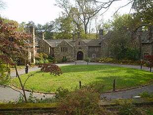
The bulk of the property was acquired in the late 1960s from the estate of well known horse breeder Walter M. Jeffords, Sr. and his wife Sarah, a niece of Samuel D. Riddle. The Jeffords had acquired the land starting about 1912 in small parcels, until they had over 2,000 acres (8.1 km2), which was the largest private undeveloped property in the Philadelphia area by the 1960s. By 1918 they had built a large mansion, now the park office, around a stone colonial farmhouse. Twenty-four other historic properties were located on the grounds, many farmsteads that had retained family ownership since the seventeenth century. In 1976 these properties were registered on the National Register of Historic Places as a national historic district.[3][4]
The area was originally settled by English Quakers and remained agrarian into the twentieth century. The oldest property is the 1683 Worrel House. In 1718 a water mill, then known as Providence Mill, began to grind corn. In the late 18th century a plaster mill was established next to the grist mill. A rolling and slitting mill replaced the plaster mill by 1812, and became known as Bishop's Mills. Workers cottages, a dam, and several outbuildings complete the mill complex, now known as Sycamore Mills.[5] The mills operated until 1901, when they were damaged by fire.[6]
Colonial Pennsylvania Plantation
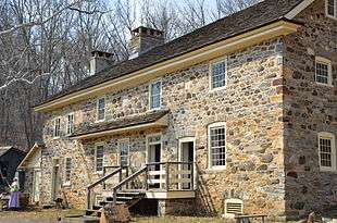
The Colonial Pennsylvania Plantation is a living museum on the 112-acre (0.45 km2) farm where the Pratt family lived from 1720 to 1820. Admission is charged and it is open to the general public on weekends from April through November.[7][8]
Recreation
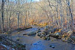
The location of Ridley Creek State Park, just 16 miles (26 km) from downtown Philadelphia, has led to its popularity. Ridley Creek is very popular with fishermen. It is stocked with trout by the Pennsylvania Fish and Boat Commission. A portion of the creek is a designated catch and release area for fly fishing only. There is a wheelchair accessible fishing platform on a multi-use trail. The 12 miles (19 km) of hiking trails at Ridley Creek State Park are popular with dog owners.[9] These trails pass through a variety of habitats. A 5-mile (8 km) multi use trail is open to jogging, bicycling and walking. The park also features a 4.7-mile (7.6 km) equestrian trail.[2][10]
Nearby state parks
The following state parks are within 30 miles (48 km) of Ridley Creek State Park:[11][12][13]
- Alapocas Run State Park (Delaware)
- Auburn Heights Preserve (Delaware)
- Bellevue State Park (Delaware)
- Benjamin Rush State Park (Philadelphia County)
- Brandywine Creek State Park (Delaware)
- Delaware Canal State Park (Bucks and Northampton Counties)
- Evansburg State Park (Montgomery County)
- Fort Delaware State Park (Delaware)
- Fort DuPont State Park (Delaware)
- Fort Mott State Park (New Jersey)
- Fort Washington State Park (Montgomery County)
- Fox Point State Park (Delaware)
- French Creek State Park (Berks and Chester Counties)
- Lums Pond State Park (Delaware)
- Marsh Creek State Park (Chester County)
- Neshaminy State Park (Bucks County)
- Norristown Farm Park (Montgomery County)
- Wilmington State Parks (Delaware)
- White Clay Creek Preserve (Chester County)
- White Clay Creek State Park (Delaware)
References
- 1 2 "Ridley Creek State Park". Geographic Names Information System. United States Geological Survey. August 30, 1990. Retrieved 2007-12-18.
- 1 2 "Ridley Creek State Park". Pennsylvania Department of Conservation and Natural Resources. Retrieved 2007-01-31.
- ↑ Barr 1993
- ↑ National Park Service (2010-07-09). "National Register Information System". National Register of Historic Places. National Park Service.
- ↑ 39°56′46″N 75°25′19″W / 39.946°N 75.422°W
- ↑ "National Historic Landmarks & National Register of Historic Places in Pennsylvania" (Searchable database). CRGIS: Cultural Resources Geographic Information System. Note: This includes Ernest Palmer, Jr. & William K. Watson (July 1976). "National Register of Historic Places Inventory Nomination Form: Ridley Creek State Park" (PDF). Retrieved 2012-01-06.
- ↑ "About Colonial Pennsylvania Plantation". Colonial Pennsylvania Plantation. Retrieved October 8, 2009.
- ↑ 39°57′54″N 75°27′04″W / 39.965°N 75.451°W
- ↑ Gelbert, Doug (2001). A Bark in the Park: A Guide for Walking Your Dog in Delaware County. Cruden Bay Books. p. 26. ISBN 096444271X, 9780964442719.
- ↑ "Friends of Ridley Creek State Park". Friends of Ridley Creek State Park Organization, Pa. Parks & Forests Foundation. Retrieved 2007-03-12.
- ↑ "Find a Park by Region (interactive map)". Pennsylvania Department of Conservation and Natural Resources. Retrieved November 18, 2011.
- ↑ 2007 General Highway Map Delaware County Pennsylvania (PDF) (Map). 1:65,000. Pennsylvania Department of Transportation, Bureau of Planning and Research, Geographic Information Division. Retrieved 2007-07-27. Note: shows Ridley Creek State Park
- ↑ Michels, Chris (1997). "Latitude/Longitude Distance Calculation". Northern Arizona University. Retrieved 2008-04-23.
Sources
- Barr, Jeffery Robert (1993). Preservation in Ridley Creek State Park: Documentation of the Historic Farmsteads. Philadelphia: University of Pennsylvania Masters Thesis. p. 142.
- National Register of Historic Places Inventory - Nomination Form Jeffords' Estate
External links
- Ridley Creek State Park Official Website
- "Ridley Creek State Park official map" (PDF). (611.3 KB)
- Colonial Pennsylvania Plantation
| Wikimedia Commons has media related to Ridley Creek State Park. |
| Topics |   | |
|---|---|---|
| Lists by county |
| |
| Lists by city | ||
| Other lists | ||
| ||