Norristown Farm Park
| Norristown Farm Park | |
|---|---|
| Pennsylvania State Park | |
| Natural Monument (IUCN III) | |
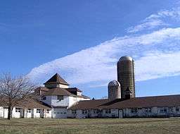 The main barn at Norristown Farm Park | |
| Country | United States |
| State | Pennsylvania |
| County | Montgomery |
| Townships | East Norriton, West Norriton, Borough of Norristown |
| Location | [1] |
| - coordinates | 40°08′01″N 75°21′02″W / 40.13361°N 75.35056°WCoordinates: 40°08′01″N 75°21′02″W / 40.13361°N 75.35056°W |
| - elevation | 180 ft (55 m) [1] |
| Area | 690 acres (279 ha) |
| Founded | 1995 |
| Managed by | Pennsylvania Department of Conservation and Natural Resources |
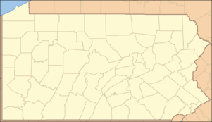 Location of Norristown Farm Park in Pennsylvania | |
| Website : Norristown Farm Park | |
Norristown Farm Park is a 690-acre (279 ha) Pennsylvania state park in East Norriton and West Norriton Townships and the Borough of Norristown, Montgomery County, Pennsylvania, in the United States.[2] It is operated in partnership with the Montgomery County Department of Parks. The park is a working farm on the site of Norristown State Hospital.[3] Many colonial era farm buildings and homes are on the grounds. Hiking, bicycling, ball fields, fishing, picnicking, and cross-country skiing are available in the park. The park hosts musical concerts in the summer. Stony Creek flows through the park. Norristown Farm Park is just off Interstate 276 on West Germantown Pike.[3]
Norristown Farm Park was originally part of a 7,000-acre (2,800 ha) tract of land called "Williamstadt," which originally belonged to William Penn.[4] The property was then transferred to Isaac Norris, the namesake of Norristown, by way of Penn's son, William Penn, Jr. Norris' heirs sold pieces of Williamstadt to the Commonwealth of Pennsylvania and Norristown State Hospital was opened in the 1870s as a mental hospital.[5] The park is on state-owned land that surrounds the hospital.[5]
Nearby state parks
The following state parks are within 30 miles (48 km) of Norristown Farm Park:[6][7][8]
- Benjamin Rush State Park (Philadelphia County)
- Bull's Island Recreation Area (New Jersey)
- Evansburg State Park (Montgomery County)
- Delaware Canal State Park (Bucks and Northampton Counties)
- Delaware and Raritan Canal State Park (New Jersey)
- French Creek State Park (Berks and Chester Counties)
- Fort Washington State Park (Montgomery County)
- Fox Point State Park (Delaware)
- Neshaminy State Park (Bucks County)
- Nockamixon State Park (Bucks County)
- Marsh Creek State Park (Chester County)
- Ralph Stover State Park (Bucks County)
- Rancocas State Park (New Jersey)
- Ridley Creek State Park (Delaware County)
- Tyler State Park (Bucks County)
- Washington Crossing State Park (New Jersey)
References
- 1 2 "Norristown Farm Park". Geographic Names Information System. United States Geological Survey. August 23, 2007. Retrieved 2008-06-18.
- ↑ "Norristown Farm State Park". Pennsylvania Department of Conservation and Natural Resources. Retrieved 2006-12-12.
- 1 2 "Norristown Farm Park Montgomery County page". County of Montgomery, PA. Retrieved 2006-12-12.
- ↑ "Norristown Farm Park Schuylkill River National and State Heritage Area". Schuylkill River Greenway Association. Retrieved 2006-12-12.
- 1 2 Reverend Judith A. Meier. "An Historic District Within the Boundaries of the Norristown State Hospital". Farm Park Preservation Association. Archived from the original on 2006-08-11. Retrieved 2007-01-22.
- ↑ "Find a Park by Region (interactive map)". Pennsylvania Department of Conservation and Natural Resources. Retrieved November 18, 2011.
- ↑ Michels, Chris (1997). "Latitude/Longitude Distance Calculation". Northern Arizona University. Retrieved 2008-04-23.
- ↑ "2007 General Highway Map Montgomery County Pennsylvania" (PDF) (Map). 1:65,000. Pennsylvania Department of Transportation, Bureau of Planning and Research, Geographic Information Division. Retrieved 2007-07-27. Note: shows Norristown Farm Park
External links
| Wikimedia Commons has media related to Norristown Farm Park. |
- "Norristown Farm Park official map" (PDF). (2.31 MB)
- Norristown Farm Park - official Montgomery County site
- Farm Park Preservation Association