Pine Grove Furnace State Park
| Pine Grove Furnace State Park | |
|---|---|
| Pennsylvania State Park | |
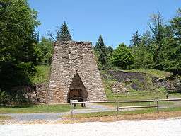 Pine Grove Furnace Stack | |
| Name origin: Pine Grove Furnace | |
| Country | United States |
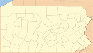
| State | Pennsylvania |
| County | Cumberland |
| Townships | Cooke, Dickinson |
| Landform Range |
Mountain Creek valley South Mountain |
| Location | Pine Grove Furnace Stack [1] |
| - coordinates | 40°01′52″N 77°18′24″W / 40.03111°N 77.30667°WCoordinates: 40°01′52″N 77°18′24″W / 40.03111°N 77.30667°W |
| Area | 696 acres (282 ha) |
| Length | 3.5 mi (6 km), dogleg northward then eastward (along Bendersville Rd & SR3008) |
| Width | 0.31 mi (0 km) (average along length) |
| Highest point | southern tip of park |
| - elevation | 1,125 ft (343 m) |
| Lowest point | Mountain Creek at bridge |
| - location | downstream of Laurel Dam |
| - elevation | 725 ft (221 m) |
| Founded | c. 1930 |
| Managed by | Bureau of State Parks |
| GNIS ID | 1196534 [1] |
 The furnace stack is ¾ mile N of the Co. line. | |
| Website : Pine Grove Furnace State Park | |
Pine Grove Furnace State Park is a protected Pennsylvania area that includes Laurel and Fuller Lakes in Cooke Township of Cumberland County. The Park accommodates various outdoor recreation activities, protects the remains of the Pine Grove Iron Works (1764), and was the site of Laurel Forge (1830), Pine Grove Park (1880s), and a brick plant (1892). The Park is 8 miles (13 km) from exit 37 of Interstate 81 on Pennsylvania Route 233.
Pine Grove Furnace State Park was chosen by the Pennsylvania Department of Conservation and Natural Resources (DCNR) and its Bureau of State Parks as one of "25 Must-See Pennsylvania State Parks".[2]
History
The state park's historic place on the national register is the Pine Grove Iron Works of about 176 acres (0.71 km2) with structures associated with the 1764 Pine Grove Furnace, which ended production in 1895.[3] The 1870 South Mountain RR and the subsequent 1891 Hunter's Run and Slate Belt Railroad provided the railway lines to the industrial areas of the state park.
Laurel Forge
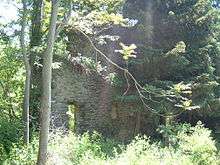
Laurel Forge manufactured wrought iron from Pine Grove Furnace pig iron and was built by Peter Ege in 1830. The Laurel Forge Pond (now Laurel Lake) was created by a dam below the Sage Run confluence at Mountain Creek to provide waterwheel power via the forge's water race. By 1873 the forge area included a boarding house, coal house, several dwellings, 2 railroad spurs, and a train depot; and in 1884 "Laurel Station" was added as a stop for excursions of the Gettysburg and Harrisburg Railroad. Laurel Dam was breached by flooding in 1889 & 1919 (downwash from both breached the Mount Holly Springs dam downstream),[4] and the lake is 25 acres (0.10 km2) of the state park.
Fuller Brick and Slate Company
The Fuller Brick and Slate Company's operations that began in 1892 were developed by J. W. Ivery at the "Pine Grove works" using clay exposed in the region's quarries. Slate was quarried 3 mi (4.8 km) southwest of the works, the soapstone was "hauled by wagon from the quarry a quarter of a mile from the works, and the clay [was] brought by rail from Laurel Station, three miles away" (the Pine Grove kiln held 12,000 bricks).[6] The soapstone was used for washing the clay (Ivery patent in 1901) and the clay was formed, dried, and kilned south of the iron works at the brick plant in front of cemetery hill[7] until c. 1913.[8]
State forest and park
The Pine Grove Division of the state's South Mountain Forest began with the South Mountain Mining & Iron Company's sale of 6,993 acres (28.30 km2) acres to the Pennsylvania Bureau of Forestry in 1912.[9] On September 12, 1913, three additional tracts totaling 9,873 acres (39.95 km2) were sold in the areas of land surrounding Pine Grove and Laurel Forge—including 1,817 acres (7.35 km2) in Adams County.[9] By 1921, "Pine Grove" was one of Pennsylvania's 7 "forest parks", within which the smaller Pine Grove Furnace State Park was established by 1931 under the 1929 Pennsylvania Bureau of State Parks (the remaining state forest was named the Michaux State Forest.)
Many of the facilities at the park were built during the Great Depression by the Civilian Conservation Corps. The young men of the CCC Camp S-51-PA constructed roads throughout the state forests, constructed bridges on the state roads, planted trees for reforestation, and cleaned streams.[10] The 1912 Reading railroad tracks have been removed, and from mid-September 2006 through July 2007, Laurel Lake and its dam were reconditioned.[11] Park lifeguards were eliminated for the 2008 season[12] but were restored to Fuller Lake in 2009[13] after a July 2008 Fuller Lake drowning, the 1st at a state park beach since 1999.[14]
| Intersection | Coordinates[16] |
|---|---|
| W park border (pt on PA 233) | 40°01′52″N 77°18′43″W / 40.0312°N 77.3119°W |
| |
40°01′55″N 77°18′36″W / 40.0319°N 77.3101°W |
| T339 & Biker/Hiker Trail | 40°01′53″N 77°18′19″W / 40.0314°N 77.3053°W |
| Mountain Cr bridge @ Fuller Lake | 40°01′51″N 77°17′52″W / 40.0308°N 77.2978°W |
| E park border (Old RR Bed Rd) | 40°01′54″N 77°17′25″W / 40.0317°N 77.2903°W |
Recreation
Fuller Lake is 1.7 acres (0.69 ha) in area and is a filled, abandoned quarry of the Pine Grove Iron Works. Boating is not permitted. Laurel Lake is a 25 acres (10 ha) body of water that was created to supply water power for Laurel Forge. Boaters are limited to using electric powered and non-powered watercraft and gas powered boats are not permitted. All boats must have a valid registration from any state.
In-season archery hunting is permitted in most of the state park, while small areas for seasonal firearms hunting are on the west and south[15] (groundhog hunting is prohibited). The beaches and swimming at Fuller and Laurel Lakes are open Memorial Day weekend through Labor Day weekend.
A former grist mill is now used as the Appalachian Trail Museum and a former inn is now the park office.
There are many picnic tables throughout the Park and two pavilions are available for rent.[18]
Hiking
The Park has 1.4 miles (2.3 km) of the Appalachian Trail over the Cumberland County Biker/Hiker Trail (rail trail) and, on the west, along 0.4 miles (0.64 km) of roadways.[15] The marker for the Appalachian Trail midpoint is east of the state park (40°1.827′N 77°17.225′W / 40.030450°N 77.287083°W), and thru-hikers completing the store's half-gallon ice cream challenge receive a commemorative wooden spoon.[19] The trails are open to cross-country skiing and some trails and roads are open to snowmobiling during the winter months.[20]
- Creek Trail is a 0.5-mile (0.80 km) trail that begins at the park amphitheater and follows Mountain Creek as it passes vernal pools and a stand of white pine trees.[20]
- Mountain Creek Trail is a 1.4-mile (2.3 km) trail that passes through wetlands and forests as it follows Mountain Creek. Hikers may get the opportunity to see white-tail deer, heron, beavers and waterfowl.[20]
- Koppenhaver Trail is 1.0-mile (1.6 km) in length and passes through a stand of mature hemlock and white pine.[20]
- Swamp Trail is 0.25-mile (0.40 km) in length and, quite naturally, passes through a swamp.[20]
Camping and lodging
Charcoal Hearth Campground along Bendersville Rd is 0.25 mi (0.40 km) south of the park's store and has 71 sites for travel trailers and tenting, and across the road is a wooded "organized group tenting" area around an open playing field (a YMCA camp is near Laurel Lake).[15] The Paymasters Cabin has central heating and is available for rent. The Ironmaster's Mansion is a youth hostel commonly used by Appalachian Trail thru-hikers.[18]
Geography and ecology
The park's portions of the Mountain Creek valley[21]:14 and the neighboring mountain slopes (Piney Mountain, Pole Steeple, & South Mountain) are part of the Appalachian-Blue Ridge forests ecoregion and have few areas that are not wooded. In addition to the typical mammals, birds, and other fauna of the northeastern US ecoregion, the park's Laurel Lake attracts migratory waterfowl of the Atlantic Flyway (butterflies reach their peak in the summer months.) The lakes have pickerel, trout and perch; while Mountain Creek has brook, brown and rainbow trout.[18]
| Wikimedia Commons has media related to Pine Grove Furnace State Park. |
|
| |
|
|
Nearby state parks
The following state parks are within 30 miles (48 km) of Pine Grove Furnace State Park:[22][23][24]
- Big Spring State Forest Picnic Area (Perry County)
- Caledonia State Park (Adams and Franklin Counties)
- Codorus State Park (York County)
- Colonel Denning State Park (Cumberland County)
- Cunningham Falls State Park (Maryland)
- Fowlers Hollow State Park (Perry County)
- Gifford Pinchot State Park (York County)
- Kings Gap Environmental Education and Training Center (Cumberland County)
- Little Buffalo State Park (Perry County)
- Mont Alto State Park (Franklin County)
References
- 1 2 "Pine Grove Furnace], [http://geonames.usgs.gov/apex/f?p=gnispq:3:::NO::P3_FID:1196534 State Park,] [http://geonames.usgs.gov/apex/f?p=gnispq:3:::NO::P3_FID:1207388 Furnace Stack". Geographic Names Information System. United States Geological Survey. Retrieved 2011-05-14. External link in
|title=(help) - ↑ "Find a Park: 25 Must-see Parks". Pennsylvania Department of Conservation and Natural Resources. Retrieved May 26, 2015.
- ↑ Birkinbine, John (1879). Experiments With Charcoal, Coke And Antracite In The Pine Grove Furnace, Pa. (Google Books). Transactions of the American Institute of Mining Engineers (Report). Volume 8. Retrieved 2011-05-19.
- ↑ "Country Flooded When Dam Broke" (Google News Archive). Gettysburg Times. July 23, 1919. Retrieved 2011-05-17.
- ↑ Ege, Rev. Thompson P.-D. D. (1911). History and Genealogy Of The Ege Family In The United States, 1738-1911 (Archive.org text). The Star Printing Company. Retrieved 2011-05-21.
December 3, 1783, Jacob Simon conveyed Pine Grove Furnace and land, together with another tract of 100 acres, to Michael Ege, Sr., Thomas and Joseph Thornburg, sons of Eobert Thorn- burg — Michael Ege one-half and the Thornburg brothers one- fourth each. … they re- sumed business, extended the railroad from a junction at Hunters Eun to Gettysburg, laid out a very beautiful excursion park near the furnace in a grove of magnificent trees, which for many years was well patronized.
- ↑ Rothwell, Richard P., ed. (1902). "The Mineral Industry … to the end of 1898" (Google Books). VII. The Engineering and Mining Journal Co. (Inc.). Retrieved 2011-05-17.
At Henry Clay Station, on the Hunter's Run & Slate Belt Railway, … The slate is brought to the works by railway from the slate quarry, about 3 miles southwest of the works; the soapstone is hauled by wagon from the quarry, a quarter of a mile from the works, and the clay is brought by rail from Laurel Station, 3 miles away. … about 3 miles below Laurel … At Crane's Siding, on the same railway, one mile above Hunter's Run Station, is a clay refining plant which has been in operation three years … The clay is obtained at the long-since abandoned Crane iron ore mine … obtained its clay from Upper Mill Station, on the Gettysburg & Harrisburg Railway
(similarly-worded Franklin Institute journal of 1899) - ↑ Keefer, Horace Andrew (October 1934) [written after January 29, 1927]. Recollections, Historical and Otherwise, Relating To Old Pine Grove Furnace (Report). Potomac Appalachian Trail Club Bulletin. Retrieved 2011-05-14.
- ↑ "Pine Grove Furnace Collection". PHMC.state.pa.us. Retrieved 2011-05-13.
- 1 2 ...Department of Forestry...Years 1912-1913 (Report). Pennsylvania Department of Forests and Waters. 1915. Retrieved 2011-05-22.
With the final purchase of the lands in Cumberland county at Pine Grove Furnace from the South Mountain Mining & Iron Company, which was consummated by deed bearing date the 12th day of September, 1913
- ↑ "Pennsylvania State Parks: The CCC Years". Pennsylvania Department of Conservation and Natural Resources. Retrieved 2006-11-28.
- ↑ http://www.dcnr.state.pa.us/news/resource/res2007/07-0703-pinegrovefurnacesp.aspx
- ↑ "Pa. state parks going without life guards at beaches in 2008". The Times Leader. Archived from the original on October 7, 2008. Retrieved 2008-02-19.
- ↑ DCNR Resource, Feb. 25, 2009 Retrieved on July 13, 2009.
- ↑ "Teen's drowning revives debate over state park lifeguards". Philadelphia Inquirer. Retrieved 2008-09-17.
- 1 2 3 4 Pine Grove Furnace State Park (PDF) (Map). DCNR.state.pa.us. Retrieved 2011-05-13.
- ↑ http://www.trimbleoutdoors.com/ViewTrip/270666
- ↑ "Pine Grove, Penn Township (sic)" (Map). Atlas of Cumberland County. Beers, F. W. 1972. Retrieved 2011-05-16.
- 1 2 3 "Pine Grove Furnace State Park". Pennsylvania Department of Conservation and Natural Resources. Retrieved 2006-11-28.
- ↑ Chris A. Courogen. "AT hikers look forward to the ice cream challenge". PennLive.com. Retrieved 2008-07-05.
- 1 2 3 4 5 "Pine Grove Furnace State Park: Hiking". Pennsylvania Department of Conservation and Natural Resources. Retrieved 2008-06-18.
- ↑ Way, John H (1986). "Your Guide to the Geology of the Kings Gap Area …" ("booklet") (Environmental Geology Report 8). Pennsylvania Geological Survey. Retrieved 2011-05-20.
At full capacity, an average furnace used 800 bushels of charcoal every 24 hours … 240 or more acres of woodland
per year.
- p. 12: Figure 6-2 (Map). Invilliers, Edward V. d'. 1886. External link in
|publisher=(help) (also published: report on the iron ore mines and limestone quarries of the Cumberland-Lebanon Valley, … in the "An. Rept. Geol. Surv. of Pennsylvania," 1886) - p. 14: Figure 7-1 (Map). Lehman, Ambrose E. 1889.
- p. 12: Figure 6-2 (Map). Invilliers, Edward V. d'. 1886. External link in
- ↑ "Find a Park by Region (interactive map)". Pennsylvania Department of Conservation and Natural Resources. Retrieved November 18, 2011.
- ↑ Michels, Chris (1997). ""Latitude/Longitude Distance Calculation"". Northern Arizona University. Retrieved 2008-04-23.
- ↑ "2007 General Highway Map Cumberland County Pennsylvania" (PDF) (Map). 1:65,000. Pennsylvania Department of Transportation, Bureau of Planning and Research, Geographic Information Division. Retrieved 2007-07-27. Note: shows Pine Grove Furnace State Park