Chicot County, Arkansas
| Chicot County, Arkansas | |
|---|---|
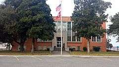 Chicot County Courthouse in Lake Village | |
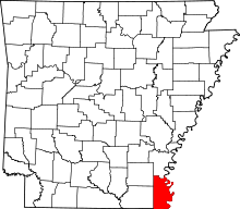 Location in the U.S. state of Arkansas | |
 Arkansas's location in the U.S. | |
| Founded | October 25, 1823 |
| Seat | Lake Village |
| Largest city | Dermott |
| Area | |
| • Total | 691 sq mi (1,790 km2) |
| • Land | 644 sq mi (1,668 km2) |
| • Water | 47 sq mi (122 km2), 6.7% |
| Population (est.) | |
| • (2015) | 11,027 |
| • Density | 18/sq mi (7/km²) |
| Congressional district | 1st |
| Time zone | Central: UTC-6/-5 |
| Website |
chicotcounty |
Chicot County is a county located in the U.S. state of Arkansas. As of the 2010 census, the population was 11,800.[1] The county seat is Lake Village.[2] Chicot County is Arkansas's tenth county, formed on October 25, 1823, and named after Point Chicot on the Mississippi River. It is part of the Arkansas Delta, historically important for cotton cultivation.
Landmarks around the county include Lake Chicot, North America's largest oxbow lake and Arkansas's largest natural lake; the site of Charles Lindbergh's first night-time flight; and the legendary burial site of Hernando De Soto, near Lake Village.
History
Prior to the American Civil War of 1861-1865, the county was home to several large cotton plantations: Sunnyside (owned in the 20th century by LeRoy Percy, planter and US Senator from Greenville, Mississippi); Florence, Patria, Pastoria, Luna, and Lakeport.[3]
During the war, Union and Confederate forces fought at the Battle of Old River Lake from June 5 to June 6, 1864.
Geography
According to the U.S. Census Bureau, the county has a total area of 691 square miles (1,790 km2), of which 644 square miles (1,670 km2) is land and 47 square miles (120 km2) (6.7%) is water.[4]
Major highways
Adjacent counties
- Desha County (north)
- Washington County, Mississippi (east)
- Issaquena County, Mississippi (southeast)
- East Carroll Parish, Louisiana (south)
- West Carroll Parish, Louisiana (southwest)
- Ashley County (west)
- Drew County (northwest)
Demographics
| Historical population | |||
|---|---|---|---|
| Census | Pop. | %± | |
| 1830 | 1,165 | — | |
| 1840 | 3,806 | 226.7% | |
| 1850 | 5,115 | 34.4% | |
| 1860 | 9,234 | 80.5% | |
| 1870 | 7,214 | −21.9% | |
| 1880 | 10,117 | 40.2% | |
| 1890 | 11,419 | 12.9% | |
| 1900 | 14,528 | 27.2% | |
| 1910 | 21,987 | 51.3% | |
| 1920 | 21,749 | −1.1% | |
| 1930 | 22,646 | 4.1% | |
| 1940 | 27,452 | 21.2% | |
| 1950 | 22,306 | −18.7% | |
| 1960 | 18,990 | −14.9% | |
| 1970 | 18,164 | −4.3% | |
| 1980 | 17,793 | −2.0% | |
| 1990 | 15,713 | −11.7% | |
| 2000 | 14,117 | −10.2% | |
| 2010 | 11,800 | −16.4% | |
| Est. 2015 | 11,027 | [5] | −6.6% |
| U.S. Decennial Census[6] 1790–1960[7] 1900–1990[8] 1990–2000[9] 2010–2015[1] | |||
As of the 2010 United States Census, there were 11,800 people residing in the county. 54.1% were Black or African American, 41.2% White, 0.5% Asian, 0.2% Native American, 3.2% of some other race and 0.8 of two or more races. 4.6% were Hispanic or Latino (of any race).
As of the 2000 United States Census,[11] there were 14,117 people, 5,205 households, and 3,643 families residing in the county. The population density was 22 people per square mile (8/km²). There were 5,974 housing units at an average density of 9 per square mile (4/km²). The racial makeup of the county was 43.24% White, 53.96% Black or African American, 0.13% Native American, 0.40% Asian, 0.02% Pacific Islander, 1.41% from other races, and 0.85% from two or more races. 2.88% of the population were Hispanic or Latino of any race.
There were 5,205 households out of which 31.70% had children under the age of 18 living with them, 43.70% were married couples living together, 22.00% had a female householder with no husband present, and 30.00% were non-families. 26.90% of all households were made up of individuals and 13.00% had someone living alone who was 65 years of age or older. The average household size was 2.58 and the average family size was 3.12.
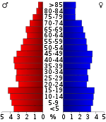
In the county the population was spread out with 27.50% under the age of 18, 8.60% from 18 to 24, 26.40% from 25 to 44, 22.20% from 45 to 64, and 15.40% who were 65 years of age or older. The median age was 36 years. For every 100 females there were 94.20 males. For every 100 females age 18 and over, there were 89.90 males.
The median income for a household in the county was $22,024, and the median income for a family was $27,960. Males had a median income of $25,899 versus $17,115 for females. The per capita income for the county was $12,825. About 23.10% of families and 28.60% of the population were below the poverty line, including 38.30% of those under age 18 and 20.70% of those age 65 or over.
As of 2010 the county population was 11,800. The racial make-up was 40.35% Non-Hispanic whites, 54.08% blacks, 0.19% Native Americans, 0.47% Asians, 0.03% Pacific Islanders and 4.59% Hispanics or Latinos.
Since 1940, the population of the county has collapsed. Press reports indicate that in 2013, the largest settlement in the county, Lake Village, Arkansas had two bank branches, a pharmacy, some law firms and no retail shops.[12]
Politics
The county is traditionally Democratic. In the 20th century, the only Democrat to lose the county was George McGovern.[13] Until the mid-1960s and passage of federal civil rights legislation, blacks had been essentially disfranchised in Arkansas and it was a one-party state of white Democrats. With national Democratic support for the civil rights struggle and legislation, especially by President Lyndon B. Johnson, many blacks have supported the party and its candidates since then.
Although there has been some trending toward the Republicans among white voters since the mid-1960s, the Republican Presidential candidate has not received over 40% in any of the last five Presidential elections.[14]
It is part of Arkansas's 1st congressional district. In the Arkansas Senate, the county is in District 26 and is represented by Democrat Eddie Cheatham. In the Arkansas House of Representatives, it is in District 1 and represented by Democrat Mark McElroy. The county supported a measure prohibiting "co-habiting couples" from adopting.[15]
| Year | GOP | DNC | Others |
|---|---|---|---|
| 2016 | 41.1% 1,716 | 56.3% 2,350 | 2.6% 110 |
| 2012 | 38.3% 1,670 | 60.7% 2,649 | 1.0% 42 |
| 2008 | 40.7% 2,119 | 58.4% 3,043 | 0.9% 46 |
| 2004 | 36.3% 1,725 | 62.9% 2,993 | 0.8% 39 |
| 2000 | 35.1% 1,564 | 63.4% 2,820 | 1.5% 68 |
Public officials
- Chicot County: Ronald Nichols (sheriff), Mack Ball Jr. (county judge)
- Dermott: Eric Evans (police chief), Morris Parker (fire chief)
- Eudora: William El-Amin (police chief), Robert Bunn (fire chief)
- Lake Village: Percy Wilburn (police chief), Sam E. Angel II (fire chief)
- Ross Van Ness: (fire chief)
Communities
Cities
- Dermott
- Eudora
- Lake Village (county seat)
Unincorporated communities
- Arkla
- Bellaire
- Cosgrove
- Chicot Junction
- Empire
- Farmwood
- Indian
- Grand Lake
- Hudspeth
- Jennie
- Lakeport
- Lakehall
- McMillian Corner
- Readland
- Ross Van Ness
- Shives
- Stuart Island
- Wellford
Ghost town
Townships
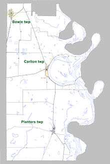
Townships in Arkansas are the divisions of a county. Each township includes unincorporated areas; some may have incorporated cities or towns within part of their boundaries. Arkansas townships have limited purposes in modern times. However, the United States Census does list Arkansas population based on townships (sometimes referred to as "county subdivisions" or "minor civil divisions"). Townships are also of value for historical purposes in terms of genealogical research. Each town or city is within one or more townships in an Arkansas county based on census maps and publications. The townships of Chicot County are listed below; listed in parentheses are the cities, towns, and/or census-designated places that are fully or partially inside the township. [17][18]
- Bowie (Dermott)
- Carlton (Lake Village)
- Planters (Eudora)
Notable people
- Larry D. Alexander - visual artist and author
- Jim Cain - American player of gridiron football
- Robert L. Hill - founder of the Progressive Farmers and Household Union of America
- Mark D. McElroy - State representative for Chicot County since 2013; resides in Desha County
- Lycurgus Johnson, the owner of the Lakeport Plantation, later a state congressman.[19]
See also
- List of lakes in Chicot County, Arkansas
- National Register of Historic Places listings in Chicot County, Arkansas
References
- 1 2 "State & County QuickFacts". United States Census Bureau. Retrieved May 20, 2014.
- ↑ "Find a County". National Association of Counties. Archived from the original on 2015-05-10. Retrieved 2011-06-07.
- ↑ Gatewood, Willard B, Jr. (Spring 1991). "Sunnyside: The Evolution of an Arkansas Plantation, 1840-1945". The Arkansas Historical Quarterly. 50 (1): 5–29. JSTOR 40022326. (registration required (help)).
- ↑ "2010 Census Gazetteer Files". United States Census Bureau. August 22, 2012. Retrieved August 25, 2015.
- ↑ "County Totals Dataset: Population, Population Change and Estimated Components of Population Change: April 1, 2010 to July 1, 2015". Retrieved July 2, 2016.
- ↑ "U.S. Decennial Census". United States Census Bureau. Archived from the original on May 11, 2015. Retrieved August 25, 2015.
- ↑ "Historical Census Browser". University of Virginia Library. Retrieved August 25, 2015.
- ↑ Forstall, Richard L., ed. (March 27, 1995). "Population of Counties by Decennial Census: 1900 to 1990". United States Census Bureau. Retrieved August 25, 2015.
- ↑ "Census 2000 PHC-T-4. Ranking Tables for Counties: 1990 and 2000" (PDF). United States Census Bureau. April 2, 2001. Retrieved August 25, 2015.
- ↑ Based on 2000 census data
- ↑ "American FactFinder". United States Census Bureau. Archived from the original on 2013-09-11. Retrieved 2011-05-14.
- ↑ Scratching a Living, The Economist, 8 June 2013
- ↑ Geographie Electorale
- ↑ "Electoral map (Zoom in on Arkansas)", The New York Times
- ↑ Arkansas election site
- ↑ "Dave Leip's Atlas of U.S. Presidential Elections". Retrieved November 15, 2016.
- ↑ 2011 Boundary and Annexation Survey (BAS): Chicot County, AR (PDF) (Map). U. S. Census Bureau. Retrieved 2011-08-11.
- ↑ "Arkansas: 2010 Census Block Maps - County Subdivision". United States Census Bureau. Retrieved May 27, 2014.
- ↑ Thomas A. DeBlack, Lycurgus Leonidas Johnson (1818–1876), The Encyclopedia of Arkansas History & Culture, March 23, 2007
 |
Drew County | Desha County | | |
| Ashley County | |
Washington County, Mississippi | ||
| ||||
| | ||||
| West Carroll Parish, Louisiana | East Carroll Parish, Louisiana | Issaquena County, Mississippi |
Municipalities and communities of Chicot County, Arkansas, United States | ||
|---|---|---|
| Cities | | |
| Unincorporated communities | ||
| Ghost town | ||
Coordinates: 33°17′53″N 91°16′30″W / 33.29806°N 91.27500°W