Clayton Township, Clayton County, Iowa
| Clayton Township | |
|---|---|
| Township | |
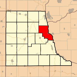 Location in Clayton County | |
| Coordinates: 42°54′53″N 091°10′04″W / 42.91472°N 91.16778°WCoordinates: 42°54′53″N 091°10′04″W / 42.91472°N 91.16778°W | |
| Country |
|
| State |
|
| County | Clayton |
| Area | |
| • Total | 38.29 sq mi (99.17 km2) |
| • Land | 34.74 sq mi (89.98 km2) |
| • Water | 3.55 sq mi (9.18 km2) 9.26% |
| Elevation | 778 ft (237 m) |
| Population (2000) | |
| • Total | 312 |
| • Density | 9/sq mi (3.5/km2) |
| GNIS feature ID | 0467613 |
Clayton Township is a township in Clayton County, Iowa, USA. As of the 2000 census, its population was 312.
History
Clayton Township was named for John M. Clayton, as was Clayton County.[1]
Geography
Clayton Township covers an area of 38.29 square miles (99.2 km2) and contains one incorporated settlement, Clayton. According to the USGS, it contains four cemeteries: Clayton, Evangelical Lutheran, Norsk Lutheran and Tangeman.
The streams of Moody Run and Sny Magill Creek run through this township.
Notes
- ↑ Price, Realto E. (1916). History of Clayton County, Iowa: From the Earliest Historical Times Down to the Present. Robert O. Law Company. p. 315.
References
External links
Municipalities and communities of Clayton County, Iowa, United States | ||
|---|---|---|
| Cities | ||
| Townships | ||
| Unincorporated communities |
| |
| Footnotes | ‡This populated place also has portions in an adjacent county or counties | |
This article is issued from Wikipedia - version of the 11/26/2016. The text is available under the Creative Commons Attribution/Share Alike but additional terms may apply for the media files.