Clayton County, Iowa
| Clayton County, Iowa | |
|---|---|
|
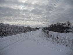
Winter scene near Elkader | |
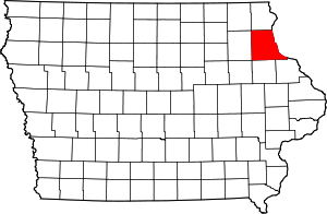 Location in the U.S. state of Iowa | |
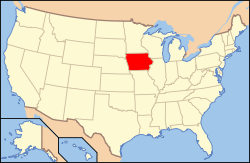 Iowa's location in the U.S. | |
| Founded | 1837 |
| Named for | John M. Clayton |
| Seat | Elkader |
| Largest city | Guttenberg |
| Area | |
| • Total | 793 sq mi (2,054 km2) |
| • Land | 779 sq mi (2,018 km2) |
| • Water | 14 sq mi (36 km2), 1.8% |
| Population | |
| • (2010) | 18,129 |
| • Density | 23/sq mi (9/km²) |
| Congressional district | 1st |
| Time zone | Central: UTC-6/-5 |
| Website |
www |
Clayton County is a county located in the U.S. state of Iowa. As of the 2010 census, the population was 18,129.[1] Its county seat is Elkader.[2] The county was established in 1837 and was named in honor of John M. Clayton,[3] United States Senator from Delaware and later Secretary of State under President Zachary Taylor.
Geography

According to the U.S. Census Bureau, the county has a total area of 793 square miles (2,050 km2), of which 779 square miles (2,020 km2) is land and 14 square miles (36 km2) (1.8%) is water.[4] It is the fifth-largest county in Iowa by area.
Adjacent counties
- Allamakee County (north)
- Crawford County, Wisconsin (northeast)
- Grant County, Wisconsin (east)
- Dubuque County (southeast)
- Delaware County (south)
- Buchanan County (southwest)
- Fayette County (west)
- Winneshiek County (northwest)
Major highways
National protected areas
- Driftless Area National Wildlife Refuge (part)
- Effigy Mounds National Monument (part)
- Upper Mississippi River National Wildlife and Fish Refuge (part)
Geology
Clayton County is part of the Driftless Area, a region that completely missed being ice-covered during the last ice age. Streams have deeply carved valleys, while the Mississippi River has spectacular bluffs.
Demographics
| Historical population | |||
|---|---|---|---|
| Census | Pop. | %± | |
| 1850 | 3,873 | — | |
| 1860 | 20,728 | 435.2% | |
| 1870 | 27,771 | 34.0% | |
| 1880 | 28,829 | 3.8% | |
| 1890 | 26,733 | −7.3% | |
| 1900 | 27,750 | 3.8% | |
| 1910 | 25,576 | −7.8% | |
| 1920 | 25,032 | −2.1% | |
| 1930 | 24,559 | −1.9% | |
| 1940 | 24,334 | −0.9% | |
| 1950 | 22,522 | −7.4% | |
| 1960 | 21,962 | −2.5% | |
| 1970 | 20,606 | −6.2% | |
| 1980 | 21,098 | 2.4% | |
| 1990 | 19,054 | −9.7% | |
| 2000 | 18,678 | −2.0% | |
| 2010 | 18,129 | −2.9% | |
| Est. 2015 | 17,644 | [5] | −2.7% |
| U.S. Decennial Census[6] 1790-1960[7] 1900-1990[8] 1990-2000[9] 2010-2013[1] | |||
2010 census
The 2010 census recorded a population of 18,129 in the county, with a population density of 23.272/sq mi (8.985/km2). There were 8,999 housing units, of which 7,599 were occupied.[10]
2000 census
As of the census[11] of 2000, there were 18,678 people, 7,375 households, and 5,132 families residing in the county. The population density was 24 people per square mile (9/km²). There were 8,619 housing units at an average density of 11 per square mile (4/km²). The racial makeup of the county was 98.93% White, 0.14% Black or African American, 0.22% Native American, 0.11% Asian, 0.01% Pacific Islander, 0.19% from other races, and 0.41% from two or more races. 0.76% of the population were Hispanic or Latino of any race.
There were 7,375 households out of which 30.90% had children under the age of 18 living with them, 59.70% were married couples living together, 6.10% had a female householder with no husband present, and 30.40% were non-families. 26.30% of all households were made up of individuals and 13.30% had someone living alone who was 65 years of age or older. The average household size was 2.47 and the average family size was 2.98.
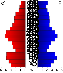
In the county the population was spread out with 25.40% under the age of 18, 6.50% from 18 to 24, 26.00% from 25 to 44, 23.60% from 45 to 64, and 18.50% who were 65 years of age or older. The median age was 40 years. For every 100 females there were 97.60 males. For every 100 females age 18 and over, there were 95.50 males.
The median income for a household in the county was $34,068, and the median income for a family was $40,199. Males had a median income of $27,165 versus $19,644 for females. The per capita income for the county was $16,930. About 5.70% of families and 8.60% of the population were below the poverty line, including 9.60% of those under age 18 and 9.40% of those age 65 or over.
Communities
Cities
Unincorporated communities
- Beulah
- Ceres
- Clayton Center
- Communia
- Eckards
- Elkport
- Fairview
- Froelich
- Giard
- Gunder
- Hardin
- Highland
- Littleport
- McGregor Heights
- Mederville
- Millville
- Motor
- Osborne
- Saint Sebald
- Thomasville
- Turkey River
- Updegraff
- Watson
- Wood
Townships
Clayton County is divided into these townships:
Population ranking
The population ranking of the following table is based on the 2010 census of Clayton County.[12]
† county seat
| Rank | City/Town/etc. | Municipal type | Population (2010 Census)
|
|---|---|---|---|
| 1 | Postville (partially in Allamakee County) | City | 2,227 |
| 2 | Guttenberg | City | 1,919 |
| 3 | Monona | City | 1,549 |
| 4 | Strawberry Point | City | 1,279 |
| 5 | † Elkader | City | 1,273 |
| 6 | McGregor | City | 871 |
| 7 | Edgewood (partially in Delaware County) | City | 864 |
| 8 | Garnavillo | City | 745 |
| 9 | Marquette | City | 375 |
| 10 | Farmersburg | City | 302 |
| 11 | Luana | City | 269 |
| 12 | Volga | City | 208 |
| 13 | North Buena Vista | City | 121 |
| 14 | St. Olaf | City | 108 |
| 15 | Garber | City | 88 |
| 16 | Osterdock | City | 59 |
| 17 | Clayton | City | 43 |
| 18 | Elkport | former City | 37 |
| 19 | Millville | former City | 30 |
See also
- National Register of Historic Places listings in Clayton County, Iowa
- The Clayton County Courthouse Article
References
- 1 2 "State & County QuickFacts". United States Census Bureau. Retrieved July 14, 2014.
- ↑ "Find a County". National Association of Counties. Archived from the original on 2011-05-31. Retrieved 2011-06-07.
- ↑ Gannett, Henry (1905). The Origin of Certain Place Names in the United States. Govt. Print. Off. p. 84.
- ↑ "US Gazetteer files: 2010, 2000, and 1990". United States Census Bureau. 2011-02-12. Retrieved 2011-04-23.
- ↑ "County Totals Dataset: Population, Population Change and Estimated Components of Population Change: April 1, 2010 to July 1, 2015". Retrieved July 2, 2016.
- ↑ "U.S. Decennial Census". United States Census Bureau. Archived from the original on May 11, 2015. Retrieved July 14, 2014.
- ↑ "Historical Census Browser". University of Virginia Library. Retrieved July 14, 2014.
- ↑ "Population of Counties by Decennial Census: 1900 to 1990". United States Census Bureau. Retrieved July 14, 2014.
- ↑ "Census 2000 PHC-T-4. Ranking Tables for Counties: 1990 and 2000" (PDF). United States Census Bureau. Retrieved July 14, 2014.
- ↑ "Population and Housing Occupancy Status: 2010 - State -- County". United States Census Bureau American FactFinder. Retrieved March 12, 2011.
- ↑ "American FactFinder". United States Census Bureau. Archived from the original on 2013-09-11. Retrieved 2008-01-31.
- ↑ "Archived copy". Archived from the original on 2013-12-21. Retrieved 2013-02-10.
External links
| Wikimedia Commons has media related to Clayton County, Iowa. |
- Clayton County official website
- Clayton County Development Corporation's website
- Clayton County Health and Demographic Data
 |
Winneshiek County | Allamakee County | Crawford County, Wisconsin | |
| Fayette County | |
Grant County, Wisconsin | ||
| ||||
| | ||||
| Buchanan County | Delaware County | Dubuque County |
Municipalities and communities of Clayton County, Iowa, United States | ||
|---|---|---|
| Cities | ||
| Townships | ||
| Unincorporated communities |
| |
| Footnotes | ‡This populated place also has portions in an adjacent county or counties | |

Coordinates: 42°50′37″N 91°20′36″W / 42.84361°N 91.34333°W