Jefferson Township, Clayton County, Iowa
| Jefferson Township | |
|---|---|
| Township | |
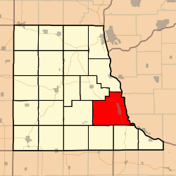 Location in Clayton County | |
| Coordinates: 42°46′57″N 091°08′00″W / 42.78250°N 91.13333°WCoordinates: 42°46′57″N 091°08′00″W / 42.78250°N 91.13333°W | |
| Country |
|
| State |
|
| County | Clayton |
| Area | |
| • Total | 57.47 sq mi (148.83 km2) |
| • Land | 50.96 sq mi (131.97 km2) |
| • Water | 6.51 sq mi (16.86 km2) 11.33% |
| Elevation | 899 ft (274 m) |
| Population (2000) | |
| • Total | 2,721 |
| • Density | 53.4/sq mi (20.6/km2) |
| GNIS feature ID | 0468132 |
Jefferson Township is a township in Clayton County, Iowa, USA. As of the 2000 census, its population was 2,721.
Geography
Jefferson Township covers an area of 57.47 square miles (148.8 km2) and contains one incorporated settlement, Guttenberg. According to the USGS, it contains nine cemeteries: Borcherding, Guttenberg, Lewis, Mount Olivet, Saint Johns, Saint Marys, Saint Michael, Saint Pauls and Stock School.
Frenchtown Lake is within this township. The streams of Buck Creek, Carlan Creek, Miners Creek, Price Branch and South Cedar Creek run through this township.
Transportation
Jefferson Township contains three airports or landing strips: Abels Island Airport, GAA Private Airport and Walters Heliport.
References
External links
Municipalities and communities of Clayton County, Iowa, United States | ||
|---|---|---|
| Cities | ||
| Townships | ||
| Unincorporated communities |
| |
| Footnotes | ‡This populated place also has portions in an adjacent county or counties | |
This article is issued from Wikipedia - version of the 11/16/2013. The text is available under the Creative Commons Attribution/Share Alike but additional terms may apply for the media files.