Millville Township, Clayton County, Iowa
| Millville Township | |
|---|---|
| Township | |
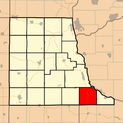 Location in Clayton County | |
| Coordinates: 42°41′30″N 091°04′27″W / 42.69167°N 91.07417°WCoordinates: 42°41′30″N 091°04′27″W / 42.69167°N 91.07417°W | |
| Country |
|
| State |
|
| County | Clayton |
| Area | |
| • Total | 35.26 sq mi (91.32 km2) |
| • Land | 34.24 sq mi (88.67 km2) |
| • Water | 1.02 sq mi (2.64 km2) 2.89% |
| Elevation | 650 ft (198 m) |
| Population (2000) | |
| • Total | 471 |
| • Density | 13.8/sq mi (5.3/km2) |
| GNIS feature ID | 0468384 |
Millville Township is a township in Clayton County, Iowa, USA. As of the 2000 census, its population was 471.
History
Millville Township is named from the mill constructed there about 1833.[1]
Geography
Millville Township covers an area of 35.26 square miles (91.3 km2) and contains one incorporated settlement, Millville. Neighboring townships include Mallory Township, Jefferson Township, and Buena Vista Township.[2] According to the USGS, it contains six cemeteries: Bierer, Friedlein, Goshen, Graham, Griffith and Redman.
The stream of Little Turkey River runs through this township.
References
- ↑ Price, Realto E. (1916). History of Clayton County, Iowa: From the Earliest Historical Times Down to the Present. Robert O. Law Company. p. 320.
- ↑ IAGenWeb Clayton County
External links
Municipalities and communities of Clayton County, Iowa, United States | ||
|---|---|---|
| Cities | ||
| Townships | ||
| Unincorporated communities |
| |
| Footnotes | ‡This populated place also has portions in an adjacent county or counties | |
This article is issued from Wikipedia - version of the 10/28/2016. The text is available under the Creative Commons Attribution/Share Alike but additional terms may apply for the media files.