Coxs Corner, Monmouth County, New Jersey
| Coxs Corner, New Jersey | |
|---|---|
| Unincorporated community | |
|
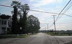
View of the intersection facing east | |
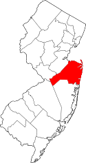
 Coxs Corner, New Jersey  Coxs Corner, New Jersey  Coxs Corner, New Jersey Cox's Corner's location in Monmouth County (Inset: Monmouth County in New Jersey) | |
| Coordinates: 40°10′54″N 74°30′41″W / 40.18167°N 74.51139°WCoordinates: 40°10′54″N 74°30′41″W / 40.18167°N 74.51139°W | |
| Country |
|
| State |
|
| County | Monmouth |
| Township | Upper Freehold |
| Named for | James Cox |
| Elevation[1] | 154 ft (47 m) |
| Time zone | Eastern (EST) (UTC-5) |
| • Summer (DST) | EDT (UTC-4) |
| GNIS feature ID | 881965[1] |
Coxs Corner, also known as Cox's Corner or Wrightsville, is an unincorporated community located within Upper Freehold Township, in Monmouth County, New Jersey, United States.[3][4] Named for congressman and brigadier general James Cox (1753–1810), who had lived here at the family home of "Box Grove", it is at the juncture of County Route 524 and County Route 43.[2][5][6] The Upper Freehold Historic Farmland Byway passes through the area.[5][7]
History
The Cox family had lived in Upper Freehold, New Jersey since the 1600s.[2] In the Upper Freehold area, farmsteads had been created by 1731 at key crossroads, one of these later being named Wrightsville just east of Cox's Corner.[8]
Cox's Corner road junction existed in colonial times and one house, Merino Hill, was built for Samuel G. Wright (1781 – 1845) who was born in Wrightsville. Like Cox, he also was elected to Congress but he died before taking office.[9][10] Merino Hill is on the National Register of Historic Places. The Department of Environmental Protection and the Monmouth County Historical Association have declared that this house together with six neighboring houses at Cox's Corner are suitable for historic village status.[9] A monument was erected in 1920 to commemorate the Cox family over five generations by recording that "Thomas and Elizabeth Blashford Cox were among the first settlers of the Province of East Jersey."[9]
The first appearance of Cox's Corner on a New Jersey map was in 1917.[2] In 1987, the then-owner of Merino Hill wrote that Wrightsville had been the name of the settlement a short distance east. However, that name fell into disuse – and that entity no longer exists – but the name was then resurrected on modern maps to erroneously name the corner itself.[11]
References
- 1 2 "Wrightsville". Geographic Names Information System. United States Geological Survey.
- 1 2 3 4 Randall Gabrielan (2001). Allentown and Upper Freehold Township. Arcadia Publishing. p. 103.
- ↑ "An Alphabetical Listing of Local Places and Incorporated Municipalities in the State of New Jersey". 1962. Retrieved 2015-03-16.
- ↑ Locality Search, State of New Jersey. Accessed March 8, 2015.
- 1 2 Meritt, Jane (29 March 2006). "Byway would lead tourists through area's unique past". The Examiner. Retrieved 17 March 2015.
- ↑ Meirs, David A. "Upper Freehold Historic Farmland Byway: Tour Narrative". Docstoc. Intuit. Retrieved 17 March 2015.
United States Congress. "Cox, James, (1753–1810) (id: C000834)". Biographical Directory of the United States Congress.
Cocks, George William (1912). The Cox Family in America. New York: George William Cocks. pp. 165, 167. Retrieved 17 March 2015. - ↑ "Scenic Byways in New Jersey Upper Freehold Historic Farmland Byway". State of New Jersey Department of Transportation. Retrieved 17 March 2015.
- ↑ Upper Freehold Historic Farmland Byway Corridor Management Plan (PDF). Upper Freehold Open Space/Farmland Preservation Committee. 2010. Retrieved 17 March 2015.
"Wright family papers". Archival Collections. Hagley Museum and Library. Retrieved 17 March 2015. - 1 2 3 Megitt, Jane (4 December 2013). "Residents acknowledge history of Cox's Corner". Examiner. Retrieved 17 March 2015.
- ↑ United States Congress. "Wright, Samuel Gardiner, (1781–1845) (id: W000769)". Biographical Directory of the United States Congress.
- ↑ Wright, Richard R.; Wright Meirs, Elizabeth G. (29 December 1987). "Merino Hill House and Farm" (PDF). National Register of Historic Places Nomination Form. National Park Service. Retrieved 17 March 2015.