Nelsonville, New Jersey
| Nelsonville, New Jersey | |
|---|---|
| Unincorporated community | |
|
Heading east through Nelsonville on CR 526 | |
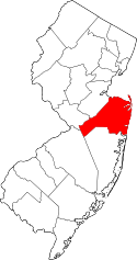
 Nelsonville, New Jersey  Nelsonville, New Jersey  Nelsonville, New Jersey Location of Nelsonville in Monmouth County Inset: Location of county within the state of New Jersey | |
| Coordinates: 40°10′13″N 74°32′06″W / 40.17028°N 74.53500°WCoordinates: 40°10′13″N 74°32′06″W / 40.17028°N 74.53500°W | |
| Country |
|
| State |
|
| County | Monmouth |
| Township | Upper Freehold |
| Named for | Charles Nelson |
| Elevation[1] | 112 ft (34 m) |
| GNIS feature ID | 878706[1] |

Nelsonville (formerly Newell and Imlaystown Station) is an unincorporated community located within Upper Freehold Township in Monmouth County, New Jersey, United States.[2] The settlement is located on County Route 526 between Allentown and Imlaystown where it intersects the former Pemberton and Hightstown Railroad.[3] The site was the location of the Newell post office established in 1883 (removed in 1923). The area was originally known as Imlaystown Station as it was the closest spot to the eponymous town along the railroad.[4] In 1887, the area was renamed to Nelsonville for the local postmaster, Charles Nelson. Other industries in the area at the time included a wagon shop and a cider mill.[5] Today, several agricultural and light industries surround the settlement in addition to some single-family homes. The right-of-way of the former railroad is being reconstructed as the Union Transportation Trail.[3]
References
- 1 2 "Nelsonville". Geographic Names Information System. United States Geological Survey.
- ↑ Locality Search, State of New Jersey. Accessed February 27, 2015.
- 1 2 Google (January 3, 2016). "Aerial view of Nelsonville" (Map). Google Maps. Google. Retrieved January 3, 2016.
- ↑ "Imlaystown Historic District". Living Places. The Gombach Group. 2011. Retrieved January 3, 2016.
[The railroad] crossed Route 526 at Nelsonville, a mile or so west of the district. ... The railroad did improve transportation. It allowed local scholars, for instance, to walk to Nelsonville and then ride to Trenton (via Hightstown and Bordentown) in order to attend Trenton High School.
- ↑ Gabrielan, Randall (2001). Images of America - Allentown and Upper Freehold Township. Arcadia Publishing. p. 107. Retrieved January 3, 2016.