Flensburg, Minnesota
| Flensburg, Minnesota | |
|---|---|
| City | |
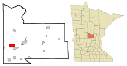 Location of Flensburg, Minnesota | |
| Coordinates: 45°56′56″N 94°31′57″W / 45.94889°N 94.53250°W | |
| Country | United States |
| State | Minnesota |
| County | Morrison |
| Area[1] | |
| • Total | 7.01 sq mi (18.16 km2) |
| • Land | 6.97 sq mi (18.05 km2) |
| • Water | 0.04 sq mi (0.10 km2) |
| Elevation | 1,211 ft (369 m) |
| Population (2010)[2] | |
| • Total | 225 |
| • Estimate (2012[3]) | 226 |
| • Density | 32.3/sq mi (12.5/km2) |
| Time zone | Central (CST) (UTC-6) |
| • Summer (DST) | CDT (UTC-5) |
| ZIP code | 56328 |
| Area code(s) | 320 |
| FIPS code | 27-21266[4] |
| GNIS feature ID | 0643739[5] |
Flensburg is a city in Morrison County, Minnesota, United States. The population was 225 at the 2010 census.[6]
History
Flensburg was named after the German town of Flensburg, a seaport in the German state of Schleswig-Holstein.[7]
After the Little Falls and Dakota Railroad was completed in 1882, there was a sidetrack to a mill in this region. The mill was called Flen's Landing or Flynn's Siding, with a depot and named for J. C. Flynn of Little Falls. Flynn was a teacher in the Little Falls schools in the late 1870s. Later, Flynn was an inspector for the Northern Pacific Railroad and a representative in the state legislature.
Flensburg was platted in March 1890 by Olaf and Dagmar Searle. The post office began in 1892 and Flensburg was incorporated on June 17, 1911.[8] Flensburg received its name in 1892.
Geography
According to the United States Census Bureau, the city has a total area of 7.01 square miles (18.16 km2), of which 6.97 square miles (18.05 km2) is land and 0.04 square miles (0.10 km2) is water.[1]
Demographics
| Historical population | |||
|---|---|---|---|
| Census | Pop. | %± | |
| 1920 | 210 | — | |
| 1930 | 284 | 35.2% | |
| 1940 | 275 | −3.2% | |
| 1950 | 281 | 2.2% | |
| 1960 | 280 | −0.4% | |
| 1970 | 259 | −7.5% | |
| 1980 | 256 | −1.2% | |
| 1990 | 213 | −16.8% | |
| 2000 | 244 | 14.6% | |
| 2010 | 225 | −7.8% | |
| Est. 2015 | 227 | [9] | 0.9% |
| U.S. Decennial Census | |||
2010 census
As of the census[2] of 2010, there were 225 people, 84 households, and 53 families residing in the city. The population density was 32.3 inhabitants per square mile (12.5/km2). There were 94 housing units at an average density of 13.5 per square mile (5.2/km2). The racial makeup of the city was 97.3% White, 0.4% Native American, 0.4% Asian, and 1.8% from two or more races.
There were 84 households of which 39.3% had children under the age of 18 living with them, 52.4% were married couples living together, 8.3% had a female householder with no husband present, 2.4% had a male householder with no wife present, and 36.9% were non-families. 33.3% of all households were made up of individuals and 15.5% had someone living alone who was 65 years of age or older. The average household size was 2.64 and the average family size was 3.43.
The median age in the city was 37.3 years. 29.3% of residents were under the age of 18; 5.8% were between the ages of 18 and 24; 22.6% were from 25 to 44; 24.5% were from 45 to 64; and 17.8% were 65 years of age or older. The gender makeup of the city was 50.2% male and 49.8% female.
2000 census
As of the census[4] of 2000, there were 244 people, 89 households, and 63 families residing in the city. The population density was 35.2 people per square mile (13.6/km²). There were 92 housing units at an average density of 13.3 per square mile (5.1/km²). The racial makeup of the city was 97.95% White, 0.82% Asian, and 1.23% from two or more races.
There were 89 households out of which 33.7% had children under the age of 18 living with them, 56.2% were married couples living together, 10.1% had a female householder with no husband present, and 28.1% were non-families. 28.1% of all households were made up of individuals and 15.7% had someone living alone who was 65 years of age or older. The average household size was 2.71 and the average family size was 3.33.
In the city the population was spread out with 31.1% under the age of 18, 8.6% from 18 to 24, 23.4% from 25 to 44, 19.7% from 45 to 64, and 17.2% who were 65 years of age or older. The median age was 35 years. For every 100 females there were 100.0 males. For every 100 females age 18 and over, there were 100.0 males.
The median income for a household in the city was $34,107, and the median income for a family was $43,125. Males had a median income of $28,750 versus $21,750 for females. The per capita income for the city was $15,652. About 4.4% of families and 8.2% of the population were below the poverty line, including 5.2% of those under the age of eighteen and 25.6% of those sixty five or over.
References
- 1 2 "US Gazetteer files 2010". United States Census Bureau. Retrieved 2012-11-13.
- 1 2 "American FactFinder". United States Census Bureau. Retrieved 2012-11-13.
- ↑ "Population Estimates". United States Census Bureau. Retrieved 2013-05-28.
- 1 2 "American FactFinder". United States Census Bureau. Retrieved 2008-01-31.
- ↑ "US Board on Geographic Names". United States Geological Survey. 2007-10-25. Retrieved 2008-01-31.
- ↑ "2010 Census Redistricting Data (Public Law 94-171) Summary File". American FactFinder. U.S. Census Bureau, 2010 Census. Retrieved 23 April 2011.
- ↑ Upham, Warren (1920). Minnesota Geographic Names: Their Origin and Historic Significance. Minnesota Historical Society. p. 352.
- ↑ "Minnesota Placenames - Township and Village Information". Minnesota Historical Society. Retrieved 20 April 2011.
- ↑ "Annual Estimates of the Resident Population for Incorporated Places: April 1, 2010 to July 1, 2015". Retrieved July 2, 2016.
External links
| Wikimedia Commons has media related to Flensburg (Minnesota). |
Municipalities and communities of Morrison County, Minnesota, United States | ||
|---|---|---|
| Cities | 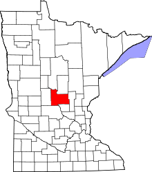 | |
| Townships | ||
| Unincorporated communities | ||
| Indian reservation | ||
| Footnotes | ‡This populated place also has portions in an adjacent county or counties | |
Coordinates: 45°57′19″N 94°32′06″W / 45.95528°N 94.53500°W