Gijounet
| Gijounet | ||
|---|---|---|
|
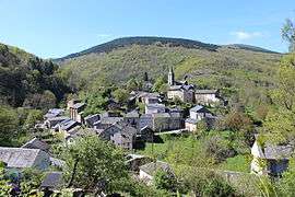
A general view of Gijounet | ||
| ||
 Gijounet | ||
|
Location within Occitanie region  Gijounet | ||
| Coordinates: 43°42′55″N 2°36′59″E / 43.7153°N 2.6164°ECoordinates: 43°42′55″N 2°36′59″E / 43.7153°N 2.6164°E | ||
| Country | France | |
| Region | Occitanie | |
| Department | Tarn | |
| Arrondissement | Castres | |
| Canton | Lacaune | |
| Government | ||
| • Mayor (2014 - 2019) | Robert Sire | |
| Area1 | 15.13 km2 (5.84 sq mi) | |
| Population (2006)2 | 134 | |
| • Density | 8.9/km2 (23/sq mi) | |
| Time zone | CET (UTC+1) | |
| • Summer (DST) | CEST (UTC+2) | |
| INSEE/Postal code | 81103 / 81530 | |
| Elevation |
530–1,060 m (1,740–3,480 ft) (avg. 550 m or 1,800 ft) | |
|
1 French Land Register data, which excludes lakes, ponds, glaciers > 1 km² (0.386 sq mi or 247 acres) and river estuaries. 2 Population without double counting: residents of multiple communes (e.g., students and military personnel) only counted once. | ||
.svg.png)
Gijounet is a commune in the Tarn department in southern France.
Geography
The river Gijou forms part of the commune's north-eastern border, then flows northwestward through the northern part of the commune.
See also
References
| Wikimedia Commons has media related to Gijounet. |
This article is issued from Wikipedia - version of the 5/17/2015. The text is available under the Creative Commons Attribution/Share Alike but additional terms may apply for the media files.