Lagrave
| Lagrave | ||
|---|---|---|
|
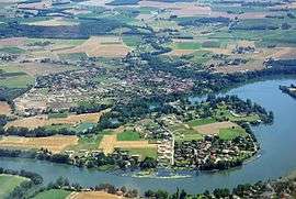
An aerial view of Lagrave | ||
| ||
 Lagrave | ||
|
Location within Occitanie region  Lagrave | ||
| Coordinates: 43°53′55″N 1°59′35″E / 43.8986°N 1.9931°ECoordinates: 43°53′55″N 1°59′35″E / 43.8986°N 1.9931°E | ||
| Country | France | |
| Region | Occitanie | |
| Department | Tarn | |
| Arrondissement | Albi | |
| Canton | Gaillac | |
| Intercommunality | Tarn and Dadou | |
| Area1 | 9.46 km2 (3.65 sq mi) | |
| Population (2006)2 | 1,686 | |
| • Density | 180/km2 (460/sq mi) | |
| Time zone | CET (UTC+1) | |
| • Summer (DST) | CEST (UTC+2) | |
| INSEE/Postal code | 81131 / 81150 | |
| Elevation |
135–205 m (443–673 ft) (avg. 155 m or 509 ft) | |
|
1 French Land Register data, which excludes lakes, ponds, glaciers > 1 km² (0.386 sq mi or 247 acres) and river estuaries. 2 Population without double counting: residents of multiple communes (e.g., students and military personnel) only counted once. | ||
.svg.png)
Lagrave is a commune in the Tarn department in southern France.
See also
References
| Wikimedia Commons has media related to Lagrave. |
This article is issued from Wikipedia - version of the 3/18/2015. The text is available under the Creative Commons Attribution/Share Alike but additional terms may apply for the media files.