Cahuzac-sur-Vère
| Cahuzac-sur-Vère | ||
|---|---|---|
|
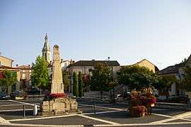
The centre of Cahuzac-sur-Vère | ||
| ||
 Cahuzac-sur-Vère | ||
|
Location within Occitanie region  Cahuzac-sur-Vère | ||
| Coordinates: 43°59′03″N 1°54′42″E / 43.9842°N 1.9117°ECoordinates: 43°59′03″N 1°54′42″E / 43.9842°N 1.9117°E | ||
| Country | France | |
| Region | Occitanie | |
| Department | Tarn | |
| Arrondissement | Albi | |
| Canton | Castelnau-de-Montmiral | |
| Intercommunality | Vère Grésigne | |
| Government | ||
| • Mayor (2008–2014) | Michel Bonnet | |
| Area1 | 30.58 km2 (11.81 sq mi) | |
| Population (2006)2 | 1,047 | |
| • Density | 34/km2 (89/sq mi) | |
| Time zone | CET (UTC+1) | |
| • Summer (DST) | CEST (UTC+2) | |
| INSEE/Postal code | 81051 / 81140 | |
| Elevation |
173–288 m (568–945 ft) (avg. 192 m or 630 ft) | |
|
1 French Land Register data, which excludes lakes, ponds, glaciers > 1 km² (0.386 sq mi or 247 acres) and river estuaries. 2 Population without double counting: residents of multiple communes (e.g., students and military personnel) only counted once. | ||
.svg.png)
Cahuzac-sur-Vère is a commune in the Tarn department in southern France. The people of Cahuzac are called Cahuzacois.
Geography
The Vère flows westward through the middle of the commune and ctosses the village.
See also
References
| Wikimedia Commons has media related to Cahuzac-sur-Vère. |
This article is issued from Wikipedia - version of the 2/11/2016. The text is available under the Creative Commons Attribution/Share Alike but additional terms may apply for the media files.