Labastide-Rouairoux
| Labastide-Rouairoux | ||
|---|---|---|
|
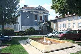
The town hall in Labastide-Rouairoux | ||
| ||
 Labastide-Rouairoux | ||
|
Location within Occitanie region  Labastide-Rouairoux | ||
| Coordinates: 43°28′34″N 2°38′23″E / 43.4761°N 2.6397°ECoordinates: 43°28′34″N 2°38′23″E / 43.4761°N 2.6397°E | ||
| Country | France | |
| Region | Occitanie | |
| Department | Tarn | |
| Arrondissement | Castres | |
| Canton | Saint-Amans-Soult | |
| Intercommunality | Haute Vallée du Thoré | |
| Government | ||
| • Mayor (2008–2014) | Francoise Fabre | |
| Area1 | 23.67 km2 (9.14 sq mi) | |
| Population (2006)2 | 1,650 | |
| • Density | 70/km2 (180/sq mi) | |
| Time zone | CET (UTC+1) | |
| • Summer (DST) | CEST (UTC+2) | |
| INSEE/Postal code | 81115 / 81270 | |
| Elevation | 364–940 m (1,194–3,084 ft) | |
|
1 French Land Register data, which excludes lakes, ponds, glaciers > 1 km² (0.386 sq mi or 247 acres) and river estuaries. 2 Population without double counting: residents of multiple communes (e.g., students and military personnel) only counted once. | ||
.svg.png)
Labastide-Rouairoux is a commune in the Tarn department in southern France.
Geography
The Thoré flows westward through the commune and crosses the village.
See also
References
| Wikimedia Commons has media related to Labastide-Rouairoux. |
This article is issued from Wikipedia - version of the 3/18/2015. The text is available under the Creative Commons Attribution/Share Alike but additional terms may apply for the media files.