List of Indiana state historical markers in Parke County
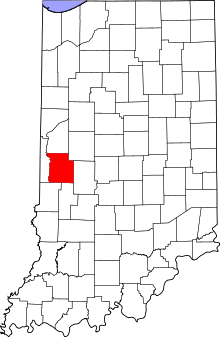
Location of Parke County in Indiana
This is a list of the Indiana state historical markers in Parke County.
This is intended to be a complete list of the official state historical markers placed in Parke County, Indiana, United States by the Indiana Historical Bureau. The locations of the historical markers and their latitude and longitude coordinates are included below when available, along with their names, years of placement, and topics as recorded by the Historical Bureau. There are 13 historical markers located in Parke County.[1]
Historical markers
| Marker title | Image | Year placed | Location | Topics |
|---|---|---|---|---|
| Wabash & Erie Canal[2] |  |
1966 | Median between U.S. Route 36 and Crawford Street near the Wabash River bridge in Montezuma 39°47′33.6″N 87°22′22″W / 39.792667°N 87.37278°W |
Transportation, Business, Industry, and Labor |
| Armiesburg[3] |  |
1966 | Western side of Lafayette Road (County Road 600W) south of U.S. Route 36 and north of Armiesburg 39°46′13″N 87°21′4.5″W / 39.77028°N 87.351250°W |
Military, Historic District, Neighborhoods, and Towns, Early Settlement and Exploration |
| Roseville[4] | 1966 | Along the Mecca-Roseville Road by the Roseville Covered Bridge near Coxville 39°39′6.6″N 87°17′39″W / 39.651833°N 87.29417°W |
Historic District, Neighborhoods, and Towns, Early Settlement and Exploration | |
| Boyhood home of J.G. "Uncle Joe" Cannon[5] | 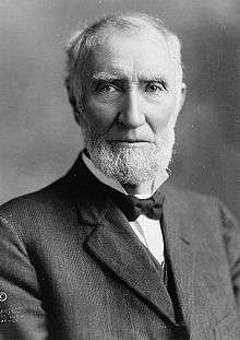 |
1966 | County Road 50W at the southern edge of Annapolis, 1 mile north of Bloomingdale 39°51′0″N 87°14′59.6″W / 39.85000°N 87.249889°W |
Politics |
| 10 O'Clock Line[6] | 1968 | Along U.S. Route 41, 4 miles south of Rockville at a church and the junction of W. Mecca Road and County Road 325W 39°43′51″N 87°18′0″W / 39.73083°N 87.30000°W |
American Indian/Native American, Early Settlement and Exploration | |
| 10 O'Clock Line[7] | 1968 | Northern side of the covered bridge and dam in northern Bridgeton 39°39′2″N 87°10′34″W / 39.65056°N 87.17611°W |
American Indian/Native American, Early Settlement and Exploration | |
| Mansfield circa 1820[8] | 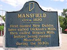 |
1968 | West of the covered bridge in Mansfield 39°40′35″N 87°6′9″W / 39.67639°N 87.10250°W |
Historic District, Neighborhoods, and Towns |
| Turkey Run[9] | 1968 | Southern side of State Road 47 at the entrance to Turkey Run State Park 39°52′55″N 87°12′7″W / 39.88194°N 87.20194°W |
Nature and Natural Disasters, Early Settlement and Exploration | |
| Dennis Hall[10] |  |
1970 | Across from the Quaker meetinghouse on the southern edge of Bloomingdale 39°49′50.7″N 87°15′6″W / 39.830750°N 87.25167°W |
Education, Religion |
| [Parke County Museum][11] | 1975 | Southern side of Ohio Street, 2 blocks east of the intersection of U.S. Routes 36 and 41 in Rockville 39°45′44″N 87°14′0″W / 39.76222°N 87.23333°W |
Arts and Culture, Buildings and Architecture | |
| Portland Mills Covered Bridge[12] |  |
1998 | Along County Road 650N southwest of Waveland 39°51′39″N 87°5′20″W / 39.86083°N 87.08889°W |
Transportation, Buildings and Architecture |
| Rockville Chautauqua Pavilion[13] | 2001 | Beechwood Park at the junction of W. Pennsylvania and S. College Streets in southwestern Rockville 39°45′34″N 87°14′6″W / 39.75944°N 87.23500°W |
Buildings and Architecture, Special Events | |
| Christmas (Noel) Dagenet[14] | 2004 | Western side of Lafayette Road (County Road 600W), 0.25 miles north of Armiesburg 39°45′47″N 87°21′4.6″W / 39.76306°N 87.351278°W |
Politics, American Indian/Native American |
See also
- List of Indiana state historical markers
- National Register of Historic Places listings in Parke County, Indiana
References
- ↑ "Indiana Historical Markers by County". State of Indiana. Retrieved 2012-03-15.
- ↑ Wabash & Erie Canal, Indiana Historical Bureau, n.d. Accessed 2012-03-14.
- ↑ Armiesburg, Indiana Historical Bureau, n.d. Accessed 2012-03-14.
- ↑ Roseville, Indiana Historical Bureau, n.d. Accessed 2012-03-14.
- ↑ Boyhood home of J.G. "Uncle Joe" Cannon, Indiana Historical Bureau, n.d. Accessed 2012-03-14.
- ↑ 10 O'Clock Line, Indiana Historical Bureau, n.d. Accessed 2012-03-14.
- ↑ 10 O'Clock Line, Indiana Historical Bureau, n.d. Accessed 2012-03-14.
- ↑ Mansfield circa 1820, Indiana Historical Bureau, n.d. Accessed 2012-03-14.
- ↑ Turkey Run, Indiana Historical Bureau, n.d. Accessed 2012-03-14.
- ↑ Dennis Hall, Indiana Historical Bureau, n.d. Accessed 2012-03-14.
- ↑ [Parke County Museum], Indiana Historical Bureau, n.d. Accessed 2012-03-14.
- ↑ Portland Mills Covered Bridge, Indiana Historical Bureau, n.d. Accessed 2012-03-14.
- ↑ Rockville Chautauqua Pavilion, Indiana Historical Bureau, n.d. Accessed 2012-03-14.
- ↑ Christmas (Noel) Dagenet, Indiana Historical Bureau, n.d. Accessed 2012-03-14.
External links
Municipalities and communities of Parke County, Indiana, United States | ||
|---|---|---|
| Towns | ||
| Townships | ||
| Unincorporated communities |
| |
| Footnotes | ‡This populated place also has portions in an adjacent county or counties | |
This article is issued from Wikipedia - version of the 8/9/2016. The text is available under the Creative Commons Attribution/Share Alike but additional terms may apply for the media files.