| [3] |
Name on the Register[4] |
Image |
Date listed[5] |
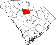
Location |
City or town |
Description |
|---|
| 1 |
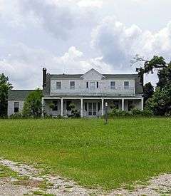
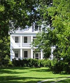
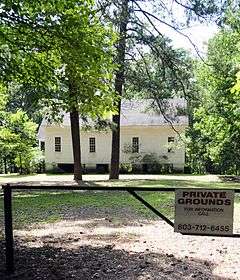
Albion |
Upload image |
000000001984-12-06-0000December 6, 1984
(#84000592) |
West of Winnsboro off South Carolina Highway 34
34°27′22″N 81°14′36″W / 34.456111°N 81.243333°W / 34.456111; -81.243333 (Albion) |
Winnsboro |
|
| 2 |
Balwearie |
|
000000001984-12-06-0000December 6, 1984
(#84000593) |
West of Winnsboro on South Carolina Highway 34
34°27′14″N 81°14′41″W / 34.453889°N 81.244722°W / 34.453889; -81.244722 (Balwearie) |
Winnsboro |
|
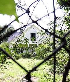
| 3 |
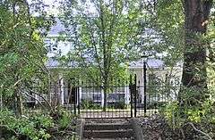
Blair Mound |
|
000000001974-08-23-0000August 23, 1974
(#74001853) |
Address Restricted
|
Winnsboro |
|
| 4 |
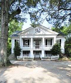
Blink Bonnie |
|
000000001972-04-13-0000April 13, 1972
(#72001209) |
About 10 miles northeast of Ridgeway
34°20′15″N 80°49′14″W / 34.3375°N 80.820556°W / 34.3375; -80.820556 (Blink Bonnie) |
Ridgeway |
|
| 5 |
Dr. Walter Brice House and Office |
|
000000001984-12-06-0000December 6, 1984
(#84000594) |
Northwest of Winnsboro
34°30′17″N 81°14′40″W / 34.504722°N 81.244444°W / 34.504722; -81.244444 (Dr. Walter Brice House and Office) |
Winnsboro |
|
| 6 |
Camp Welfare |
|
000000001984-12-06-0000December 6, 1984
(#84000586) |
Off U.S. Route 21
34°29′23″N 80°57′04″W / 34.489722°N 80.951111°W / 34.489722; -80.951111 (Camp Welfare) |
Ridgeway |
|
| 7 |
Century House |
|
000000001971-08-19-0000August 19, 1971
(#71000777) |
South Carolina Highway 34
34°18′13″N 80°57′30″W / 34.303611°N 80.958333°W / 34.303611; -80.958333 (Century House) |
Ridgeway |
|
| 8 |
Concord Presbyterian Church |
|
000000001984-12-06-0000December 6, 1984
(#84000598) |
U.S. Route 321
34°31′27″N 81°10′10″W / 34.524167°N 81.169444°W / 34.524167; -81.169444 (Concord Presbyterian Church) |
Winnsboro |
|
| 9 |
Davis Plantation |
|
000000001971-05-06-0000May 6, 1971
(#71000776) |
South of Monticello on South Carolina Highway 215
34°22′36″N 81°18′59″W / 34.376667°N 81.316389°W / 34.376667; -81.316389 (Davis Plantation) |
Monticello |
|
| 10 |
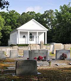
Ebenezer Associate Reformed Presbyterian Church |
|
000000001971-08-19-0000August 19, 1971
(#71000775) |
4.3 miles north of Jenkinsville on South Carolina Highway 213
34°19′09″N 81°15′39″W / 34.319167°N 81.260833°W / 34.319167; -81.260833 (Ebenezer Associate Reformed Presbyterian Church) |
Jenkinsville |
Also known as First ARP Church or "Old Brick Church." Built in 1788.
|
| 11 |
Fonti Flora Plantation |
|
000000001979-04-24-0000April 24, 1979
(#79002382) |
5.4 miles northeast of Monticello on South Carolina Highway 99
34°24′06″N 81°20′45″W / 34.401667°N 81.345833°W / 34.401667; -81.345833 (Fonti Flora Plantation) |
Monticello |
|
| 12 |
Furman Institution Faculty Residence |
Upload image |
000000001984-12-06-0000December 6, 1984
(#84000601) |
Southwest of Winnsboro
34°20′53″N 81°07′23″W / 34.348056°N 81.123056°W / 34.348056; -81.123056 (Furman Institution Faculty Residence) |
Winnsboro |
|
| 13 |
Dr. John Glenn House |
|
000000001984-12-06-0000December 6, 1984
(#84000572) |
South Carolina Highway 215
34°14′51″N 81°15′06″W / 34.2475°N 81.251667°W / 34.2475; -81.251667 (Dr. John Glenn House) |
Jenkinsville |
|
| 14 |
High Point |
|
000000001984-12-06-0000December 6, 1984
(#84000576) |
South Carolina Highway 215
34°14′47″N 81°14′56″W / 34.246389°N 81.248889°W / 34.246389; -81.248889 (High Point) |
Jenkinsville |
|
| 15 |
Hunstanton |
|
000000001984-12-06-0000December 6, 1984
(#84000604) |
U.S. Route 321
34°21′06″N 81°05′11″W / 34.351667°N 81.086389°W / 34.351667; -81.086389 (Hunstanton) |
Winnsboro |
|
| 16 |
Hunter House |
Upload image |
000000001984-12-06-0000December 6, 1984
(#84000588) |
Northeast of Ridgeway
34°19′27″N 80°56′05″W / 34.324167°N 80.934722°W / 34.324167; -80.934722 (Hunter House) |
Ridgeway |
|
| 17 |
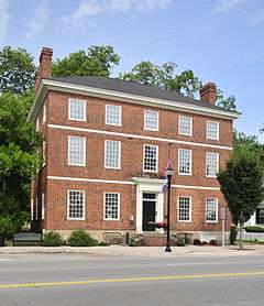
Ketchin Building |
|
000000001970-12-18-0000December 18, 1970
(#70000588) |
231 S. Congress St.
34°22′33″N 81°05′08″W / 34.375833°N 81.085556°W / 34.375833; -81.085556 (Ketchin Building) |
Winnsboro |
|
| 18 |
Kincaid-Anderson House |
Upload image |
000000001974-07-30-0000July 30, 1974
(#74001852) |
Northeast of Jenkinsville off South Carolina Highway 213
34°19′10″N 81°14′32″W / 34.319444°N 81.242222°W / 34.319444; -81.242222 (Kincaid-Anderson House) |
Jenkinsville |
|
| 19 |
Bob Lemmon House |
Upload image |
000000001984-12-06-0000December 6, 1984
(#84000607) |
Off South Carolina Highway 213
34°19′44″N 81°10′33″W / 34.328889°N 81.175833°W / 34.328889; -81.175833 (Bob Lemmon House) |
Winnsboro |
|
| 20 |
Liberty Universalist Church and Feasterville Academy Historic District |
|
000000001984-12-06-0000December 6, 1984
(#84000612) |
South Carolina Highway 215
34°30′13″N 81°21′36″W / 34.503611°N 81.36°W / 34.503611; -81.36 (Liberty Universalist Church and Feasterville Academy Historic District) |
Winnsboro |
|
| 21 |
Little River Baptist Church |
|
000000001972-04-13-0000April 13, 1972
(#72001208) |
3.8 miles north of Jenkinsville on South Carolina Highway 213
34°18′38″N 81°16′31″W / 34.310556°N 81.275278°W / 34.310556; -81.275278 (Little River Baptist Church) |
Jenkinsville |
|
| 22 |
Mayfair |
Upload image |
000000001985-02-06-0000February 6, 1985
(#85000246) |
Off South Carolina Highway 215
34°15′42″N 81°17′34″W / 34.261667°N 81.292778°W / 34.261667; -81.292778 (Mayfair) |
Jenkinsville |
|
| 23 |
McMeekin Rock Shelter |
|
000000001974-08-23-0000August 23, 1974
(#74001854) |
Address Restricted
|
Winnsboro |
|
| 24 |
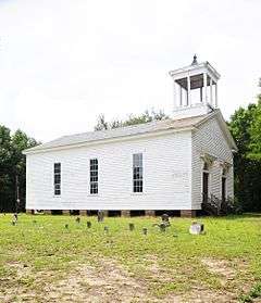
Monticello Methodist Church |
|
000000001984-12-06-0000December 6, 1984
(#84000578) |
Off South Carolina Highway 215
34°20′59″N 81°17′57″W / 34.349722°N 81.299167°W / 34.349722; -81.299167 (Monticello Methodist Church) |
Monticello |
|
| 25 |
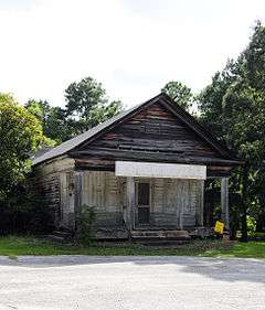
Monticello Store and Post Office |
|
000000001984-12-06-0000December 6, 1984
(#84000584) |
Off South Carolina Highway 215
34°21′11″N 81°17′58″W / 34.353056°N 81.299444°W / 34.353056; -81.299444 (Monticello Store and Post Office) |
Monticello |
|
| 26 |
Mount Hope |
Upload image |
000000001984-12-06-0000December 6, 1984
(#84000589) |
South Carolina Highway 34
34°17′58″N 80°59′18″W / 34.299444°N 80.988333°W / 34.299444; -80.988333 (Mount Hope) |
Ridgeway |
|
| 27 |
Mount Olivet Presbyterian Church |
|
000000001986-08-13-0000August 13, 1986
(#86001523) |
Off South Carolina Highway 200
34°27′55″N 81°02′02″W / 34.465278°N 81.033889°W / 34.465278; -81.033889 (Mount Olivet Presbyterian Church) |
Winnsboro |
|
| 28 |
New Hope A.R.P. Church and Session House |
|
000000001984-12-06-0000December 6, 1984
(#84000652) |
Northwest of Winnsboro
34°30′33″N 81°14′47″W / 34.509167°N 81.246389°W / 34.509167; -81.246389 (New Hope A.R.P. Church and Session House) |
Winnsboro |
|
| 29 |
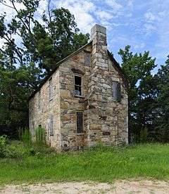
Old Stone House |
|
000000001984-12-06-0000December 6, 1984
(#84000614) |
Off South Carolina Highway 34
34°23′48″N 81°11′53″W / 34.396667°N 81.198056°W / 34.396667; -81.198056 (Old Stone House) |
Winnsboro |
|
| 30 |
Ridgeway Historic District |
|
000000001980-11-25-0000November 25, 1980
(#80004466) |
U.S. Route 21 and South Carolina Highway 34
34°18′26″N 80°57′39″W / 34.307222°N 80.960833°W / 34.307222; -80.960833 (Ridgeway Historic District) |
Ridgeway |
|
| 31 |
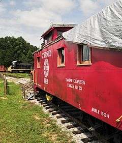
Rockton and Rion Railroad Historic District |
|
000000001984-12-06-0000December 6, 1984
(#84000617) |
South of Winnsboro from South Carolina Highway 34 west to South Carolina Highway 213
34°19′09″N 81°09′19″W / 34.319167°N 81.155278°W / 34.319167; -81.155278 (Rockton and Rion Railroad Historic District) |
Winnsboro |
|
| 32 |
Ruff's Chapel |
|
000000001980-11-25-0000November 25, 1980
(#80004400) |
U.S. Route 21 and South Carolina Highway 34
34°18′15″N 80°57′28″W / 34.304167°N 80.957778°W / 34.304167; -80.957778 (Ruff's Chapel) |
Ridgeway |
|
| 33 |
Rural Point |
|
000000001972-02-23-0000February 23, 1972
(#72001210) |
Old Camden Rd.
34°21′57″N 81°04′36″W / 34.365833°N 81.076667°W / 34.365833; -81.076667 (Rural Point) |
Winnsboro |
|
| 34 |
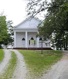
St. Stephen's Episcopal Church |
|
000000001971-05-06-0000May 6, 1971
(#71000778) |
Northeast of Ridgeway on County Road 106
34°18′42″N 80°57′23″W / 34.311667°N 80.956389°W / 34.311667; -80.956389 (St. Stephen's Episcopal Church) |
Ridgeway |
An 1854 Carpenter Gothic building which in 1920 had its wooden exterior veneered with brick. The Rev. William Porcher DuBose was an early rector.
|
| 35 |
Shivar Springs Bottling Company Cisterns |
|
000000001984-12-06-0000December 6, 1984
(#84000622) |
West of Winnsboro
34°29′19″N 81°25′15″W / 34.488611°N 81.420833°W / 34.488611; -81.420833 (Shivar Springs Bottling Company Cisterns) |
Winnsboro |
|
| 36 |
The Oaks |
|
000000001984-12-06-0000December 6, 1984
(#84000624) |
South Carolina Highway 213
34°21′15″N 81°10′44″W / 34.354167°N 81.178889°W / 34.354167; -81.178889 (The Oaks) |
Winnsboro |
|
| 37 |
Tocaland |
|
000000001984-12-06-0000December 6, 1984
(#84000627) |
Off South Carolina Highway 34
34°20′26″N 81°04′18″W / 34.340556°N 81.071667°W / 34.340556; -81.071667 (Tocaland) |
Winnsboro |
|
| 38 |
Valencia |
Upload image |
000000001971-05-06-0000May 6, 1971
(#71000779) |
Northwest of Ridgeway on County Road 106
34°19′40″N 80°59′00″W / 34.327778°N 80.983333°W / 34.327778; -80.983333 (Valencia) |
Ridgeway |
|
| 39 |
Vaughn's Stage Coach Stop |
|
000000001984-12-06-0000December 6, 1984
(#84000591) |
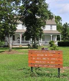
South Carolina Highway 34
34°18′36″N 81°02′00″W / 34.31°N 81.033333°W / 34.31; -81.033333 (Vaughn's Stage Coach Stop) |
Ridgeway |
|
| 40 |
White Oak Historic District |
|
000000001984-12-06-0000December 6, 1984
(#84000631) |
Off U.S. Route 321
34°28′26″N 81°07′02″W / 34.473889°N 81.117222°W / 34.473889; -81.117222 (White Oak Historic District) |
Winnsboro |
|
| 41 |
Monroe Wilson House |
|
000000001980-11-25-0000November 25, 1980
(#80004467) |
Railroad Ave. and Secondary Route S20-20
34°18′30″N 80°57′54″W / 34.308333°N 80.965°W / 34.308333; -80.965 (Monroe Wilson House) |
Ridgeway |
|
| 42 |
Winnsboro Historic District |
|
000000001971-10-14-0000October 14, 1971
(#71000780) |
Roughly bounded by Gooding, Buchanan, Garden, and Fairfield Sts.
34°22′50″N 81°05′11″W / 34.3804909°N 81.0864308°W / 34.3804909; -81.0864308 (Winnsboro Historic District) |
Winnsboro |
|


.jpg)


.jpg)

.jpg)