| [3] |
Name on the Register[4] |
Image |
Date listed[5] |
Location |
City or town |
Description |
|---|
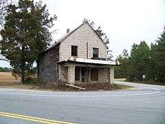
| 1 |
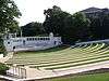
Central High School |
|
000000001994-05-20-0000May 20, 1994
(#94000475) |
304 Church St.
34°43′22″N 82°46′52″W / 34.722778°N 82.781111°W / 34.722778; -82.781111 (Central High School) |
Central |
|
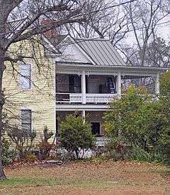
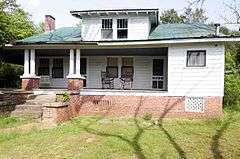
| 2 |
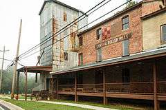
Central Roller Mills |
|
000000002013-06-25-0000June 25, 2013
(#13000454) |
300 Madden Bridge Rd.
34°43′29″N 82°47′05″W / 34.72465°N 82.78482°W / 34.72465; -82.78482 (Central Roller Mills) |
Central |
|
| 3 |
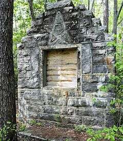
Civilian Conservation Corps Quarry No. 1 and Truck Trail |
Upload image |
000000001989-06-16-0000June 16, 1989
(#89000479) |
Off Section Rd. 25/Hickory Hollow Rd., 0.7 miles south of South Carolina Highway 11
35°00′17″N 82°42′46″W / 35.004722°N 82.712778°W / 35.004722; -82.712778 (Civilian Conservation Corps Quarry No. 1 and Truck Trail) |
Pickens |
|
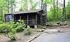
| 4 |
Civilian Conservation Corps Quarry No. 2 |
Upload image |
000000001989-06-16-0000June 16, 1989
(#89000480) |
0.2 miles north of Section Rd. 69/Sliding Rock Rd. near the Oolenoy River
35°00′21″N 82°43′18″W / 35.005833°N 82.721667°W / 35.005833; -82.721667 (Civilian Conservation Corps Quarry No. 2) |
Pickens |
|
| 5 |
Clemson College Sheep Barn |
|
000000001990-01-04-0000January 4, 1990
(#89002140) |
S. Palmetto Boulevard on the Clemson University campus
34°40′36″N 82°49′50″W / 34.676667°N 82.830556°W / 34.676667; -82.830556 (Clemson College Sheep Barn) |
Clemson |
|
| 6 |
Clemson University Historic District I |
|
000000001990-01-04-0000January 4, 1990
(#89002138) |
Northern portion of campus along U.S. Route 76
34°40′47″N 82°50′04″W / 34.679722°N 82.834444°W / 34.679722; -82.834444 (Clemson University Historic District I) |
Clemson |
|
| 7 |
Clemson University Historic District II |
|
000000001990-01-04-0000January 4, 1990
(#89002139) |
Center of campus
34°40′40″N 82°50′18″W / 34.677778°N 82.838333°W / 34.677778; -82.838333 (Clemson University Historic District II) |
Clemson |
|
| 8 |
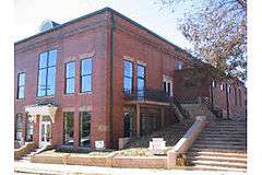
Easley High School Auditorium |
|
000000001999-01-21-0000January 21, 1999
(#98001646) |
112 Russell St.
34°50′N 82°36′W / 34.83°N 82.6°W / 34.83; -82.6 (Easley High School Auditorium) |
Easley |
|
| 9 |
Easley Mill |
|
000000002013-09-23-0000September 23, 2013
(#09000818) |
601 S. 5th St.,
34°49′27″N 82°36′28″W / 34.824109°N 82.607725°W / 34.824109; -82.607725 (Easley Mill) |
Easley |
|
| 10 |
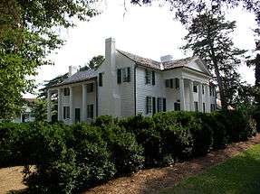
Fort Hill |
|
000000001966-10-15-0000October 15, 1966
(#66000708) |
Clemson University campus
34°40′40″N 82°50′21″W / 34.677778°N 82.839167°W / 34.677778; -82.839167 (Fort Hill) |
Clemson |
|
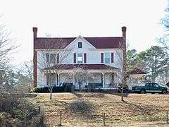
| 11 |
Griffin-Christopher House |
|
000000002001-10-21-0000October 21, 2001
(#01001160) |
208 Ann St.
34°53′06″N 82°42′30″W / 34.885°N 82.708333°W / 34.885; -82.708333 (Griffin-Christopher House) |
Pickens |
|
| 12 |
Hagood Mill |
|
000000001972-12-11-0000December 11, 1972
(#72001217) |
3.5 miles northwest of Pickens on U.S. Route 178
34°55′37″N 82°43′20″W / 34.926944°N 82.722222°W / 34.926944; -82.722222 (Hagood Mill) |
Pickens |
Includes Hagood Creek Petroglyph Site
|
| 13 |
Hagood-Mauldin House |
|
000000001997-10-09-0000October 9, 1997
(#97001185) |
104 N. Lewis St.
34°53′07″N 82°42′20″W / 34.885278°N 82.705556°W / 34.885278; -82.705556 (Hagood-Mauldin House) |
Pickens |
|
| 14 |
Hanover House |
|
000000001970-06-05-0000June 5, 1970
(#70000594) |
Clemson University campus
34°40′35″N 82°49′52″W / 34.676389°N 82.831111°W / 34.676389; -82.831111 (Hanover House) |
Clemson |
|
| 15 |
Hester Store |
|
000000002013-02-05-0000February 5, 2013
(#12001263) |
1735 Hester Store Rd.
34°53′48″N 82°32′20″W / 34.89657°N 82.538869°W / 34.89657; -82.538869 (Hester Store) |
Dacusville |
|
| 16 |
Liberty Colored High School |
|
000000002003-04-18-0000April 18, 2003
(#03000270) |
Junction of South Carolina Highway 93 and Rosewood St.
34°47′23″N 82°41′23″W / 34.789722°N 82.689722°W / 34.789722; -82.689722 (Liberty Colored High School) |
Liberty |
|
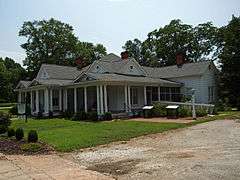
| 17 |
Morgan House |
|
000000002001-03-29-0000March 29, 2001
(#01000312) |
416 Church St.
34°43′20″N 82°46′49″W / 34.722222°N 82.780278°W / 34.722222; -82.780278 (Morgan House) |
Central |
|
| 18 |
Old Pickens Jail |
|
000000001979-04-11-0000April 11, 1979
(#79002390) |
Johnson and Pendleton Sts.
34°52′51″N 82°42′21″W / 34.880833°N 82.705833°W / 34.880833; -82.705833 (Old Pickens Jail) |
Pickens |
|
| 19 |
Old Stone Church and Cemetery |
|
000000001971-11-05-0000November 5, 1971
(#71000794) |
1.5 miles north of Pendleton off U.S. Route 76
34°39′49″N 82°48′58″W / 34.663611°N 82.816111°W / 34.663611; -82.816111 (Old Stone Church and Cemetery) |
Pendleton |
|
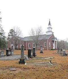
| 20 |
Oolenoy Baptist Church Cemetery |
|
000000002003-10-14-0000October 14, 2003
(#03000659) |
201 Miracle Hill Rd.
34°59′30″N 82°48′21″W / 34.991667°N 82.805833°W / 34.991667; -82.805833 (Oolenoy Baptist Church Cemetery) |
Pickens |
|
| 21 |
Pendleton Historic District |
|
000000001970-08-25-0000August 25, 1970
(#70000560) |
Bounded on the west by Hopewell and Treaty Oak, on the north by the Old Stone Church, on the east by Montpelier, and on the south by the town limits
34°39′06″N 82°47′02″W / 34.651772°N 82.78375°W / 34.651772; -82.78375 (Pendleton Historic District) |
Pendleton |
Extends into Anderson and Oconee counties
|
| 22 |
Roper House Complex |
|
000000001989-06-16-0000June 16, 1989
(#89000482) |
Section Road 25, 0.1 miles southeast of South Carolina Highway 11
35°01′18″N 82°41′32″W / 35.021667°N 82.692222°W / 35.021667; -82.692222 (Roper House Complex) |
Pickens |
|
| 23 |
Sheriff Mill Complex |
|
000000001987-11-20-0000November 20, 1987
(#87002058) |
South Carolina Highway 40
34°47′18″N 82°34′08″W / 34.788333°N 82.568889°W / 34.788333; -82.568889 (Sheriff Mill Complex) |
Easley |
|
| 24 |
J. Warren Smith House |
|
000000002005-01-26-0000January 26, 2005
(#04001564) |
21 N. Palmetto St.
34°47′09″N 82°41′47″W / 34.785833°N 82.696389°W / 34.785833; -82.696389 (J. Warren Smith House) |
Liberty |
|
| 25 |
J. C. Stribling Barn |
|
000000002001-10-22-0000October 22, 2001
(#01001161) |
220 Issaqueena Trail
34°40′07″N 82°47′45″W / 34.668611°N 82.795833°W / 34.668611; -82.795833 (J. C. Stribling Barn) |
Clemson |
|
| 26 |
Structural Science Building |
|
000000002010-04-05-0000April 5, 2010
(#09000365) |
Palmetto Boulevard and Fernow Drive
34°40′31″N 82°50′18″W / 34.675139°N 82.838333°W / 34.675139; -82.838333 (Structural Science Building) |
Clemson |
Now known as Lee and Lowry Halls; built in 1958 and designed by Harlan Ewart McClure, the first dean of architecture at Clemson University[6]
|
| 27 |
Table Rock Civilian Conservation Corps Camp Site |
|
000000001989-06-16-0000June 16, 1989
(#89000481) |
Table Rock State Park Rd. Extension at South Carolina Highway 11
35°01′18″N 82°41′55″W / 35.021667°N 82.698611°W / 35.021667; -82.698611 (Table Rock Civilian Conservation Corps Camp Site) |
Pickens |
|
| 28 |
Table Rock State Park Historic District |
|
000000001989-06-15-0000June 15, 1989
(#89000478) |
South Carolina Highway 11, 4.5 miles east of Primary Road 45
35°02′07″N 82°42′31″W / 35.035278°N 82.708611°W / 35.035278; -82.708611 (Table Rock State Park Historic District) |
Pickens |
|
| 29 |
Williams-Ligon House |
Upload image |
000000002012-02-08-0000February 8, 2012
(#12000015) |
1866 Farrs Bridge Rd.
34°54′10″N 82°37′03″W / 34.902647°N 82.617367°W / 34.902647; -82.617367 (Williams-Ligon House) |
Easley |
|
.JPG)
.JPG)


.jpg)
.JPG)
.JPG)
.JPG)
.JPG)
.JPG)
.JPG)
.JPG)
.JPG)
.JPG)