| [3] |
Name on the Register[4] |
Image |
Date listed[5] |
Location |
City or town |
Description |
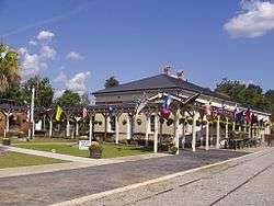
|---|
| 1 |
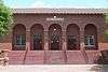
All Star Bowling Lane |
|
000000001996-08-07-0000August 7, 1996
(#96000837) |
559 E. Russell St.
33°29′34″N 80°51′34″W / 33.4929°N 80.859515°W / 33.4929; -80.859515 (All Star Bowling Lane) |
Orangeburg |
Protest against the bowling center's segregationist policy in 1968 led to the Orangeburg massacre in which 3 were killed
|
| 2 |
Amelia Street Historic District |
Upload image |
000000001985-09-20-0000September 20, 1985
(#85002322) |
Amelia St. between Treadwell St. and Summers Ave.
33°29′39″N 80°51′37″W / 33.494167°N 80.860278°W / 33.494167; -80.860278 (Amelia Street Historic District) |
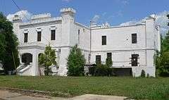
Orangeburg |
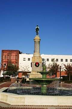
|
| 3 |
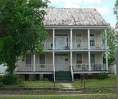
F.H.W. Briggman House |
|
000000001985-09-20-0000September 20, 1985
(#85002337) |
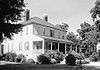
156 Amelia St.
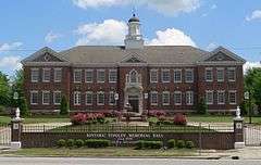
33°29′25″N 80°51′56″W / 33.490261°N 80.865601°W / 33.490261; -80.865601 (F.H.W. Briggman House) |
Orangeburg |
|
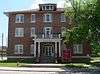
| 4 |
Donald Bruce House |
Upload image |
000000001978-12-01-0000December 1, 1978
(#78002528) |
Southeast of Orangeburg on U.S. Route 301
33°28′36″N 80°48′53″W / 33.476667°N 80.814722°W / 33.476667; -80.814722 (Donald Bruce House) |
Orangeburg |
|
| 5 |
Cattle Creek Campground |
Upload image |
000000001983-05-19-0000May 19, 1983
(#83002204) |
Off South Carolina Highway 210
33°19′20″N 80°45′08″W / 33.322222°N 80.752222°W / 33.322222; -80.752222 (Cattle Creek Campground) |
Rowesville |
|
| 6 |
Claflin College Historic District |
|
000000001985-09-20-0000September 20, 1985
(#85002324) |
On a portion of the Claflin College campus
33°29′51″N 80°51′18″W / 33.4975°N 80.855°W / 33.4975; -80.855 (Claflin College Historic District) |
Orangeburg |
|
| 7 |
Cope Depot |
Upload image |
000000002001-03-29-0000March 29, 2001
(#01000298) |
Cope Rd.
33°22′39″N 81°00′28″W / 33.3775°N 81.007778°W / 33.3775; -81.007778 (Cope Depot) |
Cope |
|
| 8 |
Dantzler Plantation |
Upload image |
000000002007-03-01-0000March 1, 2007
(#07000098) |
2755 Vance Rd.
33°24′56″N 80°30′23″W / 33.415608°N 80.506383°W / 33.415608; -80.506383 (Dantzler Plantation) |
Holly Hill |
|
| 9 |
Dixie Library Building |
Upload image |
000000001985-09-20-0000September 20, 1985
(#85002336) |
Corner of Bull and Middleton Sts.[6]
33°29′33″N 80°52′06″W / 33.4925°N 80.868333°W / 33.4925; -80.868333 (Dixie Library Building) |
Orangeburg |
|
| 10 |
Dukes Gymnasium |
|
000000001985-09-20-0000September 20, 1985
(#85002321) |
South Carolina State University campus
33°29′50″N 80°51′01″W / 33.497326°N 80.850374°W / 33.497326; -80.850374 (Dukes Gymnasium) |
Orangeburg |
|
| 11 |
East Russell Street Area Historic District |
Upload image |
000000001985-09-20-0000September 20, 1985
(#85002335) |
Along sections of E. Russell St. between Watson and Clarendon Sts., and along portions of Oakland Pl. and Dickson and Whitman Sts.
33°29′36″N 80°51′04″W / 33.493333°N 80.851111°W / 33.493333; -80.851111 (East Russell Street Area Historic District) |
Orangeburg |
|
| 12 |
Ellis Avenue Historic District |
Upload image |
000000001985-09-20-0000September 20, 1985
(#85002327) |
Along portions of Ellis Ave. between Summers Ave. and Wilson St.
33°29′53″N 80°51′47″W / 33.498056°N 80.863056°W / 33.498056; -80.863056 (Ellis Avenue Historic District) |
Orangeburg |
|
| 13 |
Enterprise Cotton Mills Building |
|
000000001985-09-20-0000September 20, 1985
(#85002340) |
U.S. Route 21
33°29′14″N 80°51′14″W / 33.487161°N 80.853977°W / 33.487161; -80.853977 (Enterprise Cotton Mills Building) |
Orangeburg |
|
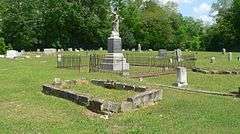
| 14 |
Eutaw Springs Battleground Park |
|
000000001970-06-05-0000June 5, 1970
(#70000593) |
2 miles east of Eutawville on South Carolina Highways 6 and 45
33°24′30″N 80°17′57″W / 33.408333°N 80.299167°W / 33.408333; -80.299167 (Eutaw Springs Battleground Park) |
Eutawville |
|
| 15 |
Maj. John Hammond Fordham House |
Upload image |
000000001985-09-20-0000September 20, 1985
(#85002341) |
415 Boulevard
33°29′58″N 80°51′20″W / 33.499444°N 80.855556°W / 33.499444; -80.855556 (Maj. John Hammond Fordham House) |
Orangeburg |
|
| 16 |
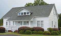
Great Branch Teacherage |
|
000000002007-10-24-0000October 24, 2007
(#07001112) |
2890 Neeses Highway
33°31′20″N 81°00′13″W / 33.522244°N 81.0036°W / 33.522244; -81.0036 (Great Branch Teacherage) |
Orangeburg |
|
| 17 |
Hodge Hall |
|
000000001985-09-20-0000September 20, 1985
(#85002320) |
South Carolina State University campus
33°29′51″N 80°51′06″W / 33.497615°N 80.851643°W / 33.497615; -80.851643 (Hodge Hall) |
Orangeburg |
|
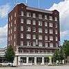
| 18 |
Hotel Eutaw |
|
000000001985-09-20-0000September 20, 1985
(#85002318) |
Russell and Centre Sts.
33°29′29″N 80°51′38″W / 33.491481°N 80.860511°W / 33.491481; -80.860511 (Hotel Eutaw) |
Orangeburg |
|
| 19 |
Lowman Hall, South Carolina State College |
|
000000001985-09-20-0000September 20, 1985
(#85002346) |
South Carolina State College campus
33°29′43″N 80°51′14″W / 33.495323°N 80.853790°W / 33.495323; -80.853790 (Lowman Hall, South Carolina State College) |
Orangeburg |
|
| 20 |
Alan Mack Site (38OR67) |
|
000000001986-01-06-0000January 6, 1986
(#86000044) |
Address Restricted
|
Orangeburg |
|
| 21 |
Mt. Pisgah Baptist Church |
|
000000001985-09-20-0000September 20, 1985
(#85002342) |
310 Green
33°29′34″N 80°51′55″W / 33.492891°N 80.865154°W / 33.492891; -80.865154 (Mt. Pisgah Baptist Church) |
Orangeburg |
|
| 22 |
Numertia Plantation |
|
000000001982-03-19-0000March 19, 1982
(#82003898) |
East of Eutawville
33°23′00″N 80°16′51″W / 33.383333°N 80.280833°W / 33.383333; -80.280833 (Numertia Plantation) |
Eutawville |
|
| 23 |
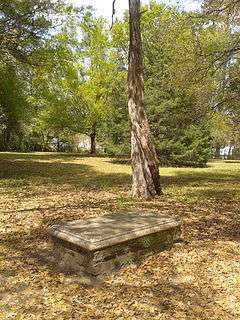
Orangeburg City Cemetery |
|
000000001996-09-27-0000September 27, 1996
(#96001025) |
Junction of Bull and Windsor Sts.
33°29′21″N 80°52′15″W / 33.489154°N 80.870756°W / 33.489154; -80.870756 (Orangeburg City Cemetery) |
Orangeburg |
|
| 24 |
Orangeburg County Fair Main Exhibit Building |
|
000000001985-09-20-0000September 20, 1985
(#85002344) |
U.S. Route 21
33°28′49″N 80°51′10″W / 33.480274°N 80.852768°W / 33.480274; -80.852768 (Orangeburg County Fair Main Exhibit Building) |
Orangeburg |
|
| 25 |
Orangeburg County Jail |
|
000000001973-10-02-0000October 2, 1973
(#73001724) |
44 Saint John St.
33°29′22″N 80°51′42″W / 33.489540°N 80.861552°W / 33.489540; -80.861552 (Orangeburg County Jail) |
Orangeburg |
|
| 26 |
Orangeburg Downtown Historic District |
|
000000001985-09-20-0000September 20, 1985
(#85002317) |
Russell, Broughton, Middleton, Church, Meeting, St. John, Hampton, and Amelia Sts. around the public square
33°29′24″N 80°51′49″W / 33.49°N 80.863611°W / 33.49; -80.863611 (Orangeburg Downtown Historic District) |
Orangeburg |
|
| 27 |
Providence Methodist Church |
|
000000002009-09-25-0000September 25, 2009
(#08001395) |
4833 Old State Rd.
33°23′33″N 80°32′26″W / 33.392529°N 80.540493°W / 33.392529; -80.540493 (Providence Methodist Church) |
Holly Hill |
|
| 28 |
St. Julien Plantation |
Upload image |
000000001980-11-28-0000November 28, 1980
(#80003693) |
South Carolina Highway 6
33°24′35″N 80°21′11″W / 33.409722°N 80.353056°W / 33.409722; -80.353056 (St. Julien Plantation) |
Eutawville |
|
| 29 |
South Carolina State College Historic District |
Upload image |
000000001997-06-19-0000June 19, 1997
(#96001024) |
300 College St.
33°29′46″N 80°51′11″W / 33.496111°N 80.853056°W / 33.496111; -80.853056 (South Carolina State College Historic District) |
Orangeburg |
|
| 30 |
Southern Railway Passenger Depot |
|
000000001973-04-23-0000April 23, 1973
(#73001723) |
110 N. Main St.
33°15′04″N 80°48′57″W / 33.251111°N 80.815833°W / 33.251111; -80.815833 (Southern Railway Passenger Depot) |
Branchville |
|
| 31 |
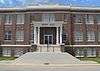
Springfield High School |
Upload image |
000000002001-03-29-0000March 29, 2001
(#01000313) |
Brodie St., between South Carolina Highway 4 and Georgia St.
33°29′44″N 81°16′27″W / 33.495556°N 81.274167°W / 33.495556; -81.274167 (Springfield High School) |
Springfield |
|
| 32 |
William P. Stroman House |
Upload image |
000000001996-08-01-0000August 1, 1996
(#96000836) |
1017 N. Boulevard
33°30′12″N 80°51′34″W / 33.503333°N 80.859444°W / 33.503333; -80.859444 (William P. Stroman House) |
Orangeburg |
|
| 33 |
Tingley Memorial Hall, Claflin College |
|
000000001983-08-04-0000August 4, 1983
(#83002205) |
College Ave.
33°29′54″N 80°51′16″W / 33.498414°N 80.854333°W / 33.498414; -80.854333 (Tingley Memorial Hall, Claflin College) |
Orangeburg |
|
| 34 |
Treadwell Street Historic District |
Upload image |
000000001985-09-20-0000September 20, 1985
(#85002315) |
Along portions of Treadwell and Amelia Sts.
33°29′45″N 80°51′30″W / 33.495833°N 80.858333°W / 33.495833; -80.858333 (Treadwell Street Historic District) |
Orangeburg |
|
| 35 |
Trinity Lutheran Church |
Upload image |
000000002008-08-01-0000August 1, 2008
(#08000721) |
390 Hampton St.
33°31′59″N 80°34′17″W / 33.533014°N 80.571467°W / 33.533014; -80.571467 (Trinity Lutheran Church) |
Elloree |
|
| 36 |
Trinity Methodist Episcopal Church |
|
000000001994-08-26-0000August 26, 1994
(#94001053) |
185 Boulevard NE.
33°29′44″N 80°51′23″W / 33.495569°N 80.856505°W / 33.495569; -80.856505 (Trinity Methodist Episcopal Church) |
Orangeburg |
|
| 37 |
White House United Methodist Church |
|
000000001974-05-13-0000May 13, 1974
(#74001872) |
Near intersection of U.S. Highway 301 and Interstate 26[7]
33°27′35″N 80°43′05″W / 33.459763°N 80.718082°W / 33.459763; -80.718082 (White House United Methodist Church) |
Orangeburg |
|
| 38 |
Whitman Street Area Historic District |
Upload image |
000000001985-09-20-0000September 20, 1985
(#85002326) |
Along sections of Whitman, Elliot, and E. Russell Sts.
33°29′28″N 80°51′29″W / 33.491111°N 80.858056°W / 33.491111; -80.858056 (Whitman Street Area Historic District) |
Orangeburg |
|
| 39 |
Williams Chapel A.M.E. Church |
|
000000001985-09-20-0000September 20, 1985
(#85002345) |
1198 Glover St.[8]
33°29′11″N 80°51′38″W / 33.486266°N 80.860517°W / 33.486266; -80.860517 (Williams Chapel A.M.E. Church) |
Orangeburg |
|
| 40 |
Willow Consolidated High School |
Upload image |
000000002006-07-11-0000July 11, 2006
(#06000581) |
2750 Cope Rd.
33°26′53″N 81°09′20″W / 33.448056°N 81.155556°W / 33.448056; -81.155556 (Willow Consolidated High School) |
Norway |
|
_sign_from_SW_1.JPG)
.jpg)
_from_NW_1.JPG)
_from_S_1.JPG)
.jpg)
_from_S_2.JPG)
_from_SE_2.JPG)
_from_SW_1.JPG)
_from_NW_1.JPG)