| [3] |
Name on the Register[4] |
Image |
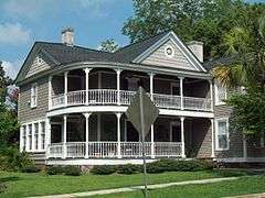
Date listed[5] |
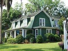
Location |
City or town |
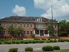
Description |
|---|
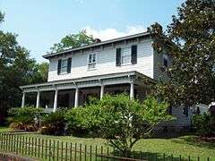
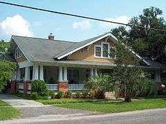
| 1 |
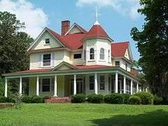
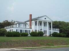
H.W. Ambrose House |
|
000000001986-08-05-0000August 5, 1986
(#86002219) |
1503 Elm Street
33°50′47″N 79°03′32″W / 33.846389°N 79.058889°W / 33.846389; -79.058889 (H.W. Ambrose House) |
Conway |
|
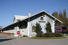
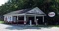
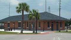
| 2 |
Atlantic Coast Line Railroad Depot |
|
000000001995-05-18-0000May 18, 1995
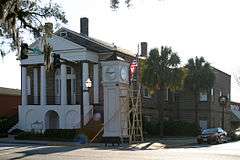
(#86003839) |
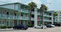
Northern side of U.S. Route 701
33°50′17″N 79°02′36″W / 33.838056°N 79.043333°W / 33.838056; -79.043333 (Atlantic Coast Line Railroad Depot) |
Conway |
|
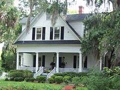
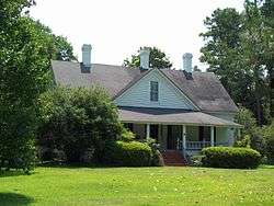
| 3 |
Beaty-Little House |
|
000000001986-08-05-0000August 5, 1986
(#86002220) |
507 Main Street
33°50′18″N 79°02′56″W / 33.838333°N 79.048889°W / 33.838333; -79.048889 (Beaty-Little House) |
Conway |
|
| 4 |
Beaty-Spivey House |
|
000000001986-08-05-0000August 5, 1986
(#86002223) |
428 Kingston Street
33°50′15″N 79°02′47″W / 33.8375°N 79.046389°W / 33.8375; -79.046389 (Beaty-Spivey House) |
Conway |
|
| 5 |
Buck's Upper Mill Farm |
|
000000001982-03-25-0000March 25, 1982
(#82003868) |
North of Bucksville
33°44′19″N 79°03′48″W / 33.738611°N 79.063333°W / 33.738611; -79.063333 (Buck's Upper Mill Farm) |
Bucksville |
|
| 6 |
Burroughs School |
|
000000001984-08-02-0000August 2, 1984
(#84002047) |
801 Main Street
33°50′30″N 79°03′07″W / 33.841667°N 79.051944°W / 33.841667; -79.051944 (Burroughs School) |
Conway |
|
| 7 |
Arthur M. Burroughs House |
|
000000001986-08-05-0000August 5, 1986
(#86002224) |
500 Lakeside Drive
33°50′27″N 79°02′50″W / 33.840833°N 79.047222°W / 33.840833; -79.047222 (Arthur M. Burroughs House) |
Conway |
|
| 8 |
Conway Downtown Historic District |
|
000000001994-08-19-0000August 19, 1994
(#94000815) |
Roughly bounded by 4th Avenue, Kingston Street, 3rd Avenue, and Laurel Street
33°50′10″N 79°02′51″W / 33.836111°N 79.0475°W / 33.836111; -79.0475 (Conway Downtown Historic District) |
Conway |
Boundary Increase (listed 3/31/2010): Portions of Main St, 3rd Ave, 4th Ave, Laurel St.
|
| 9 |
Conway Methodist Church, 1898 and 1910 Sanctuaries |
|
000000001986-08-05-0000August 5, 1986
(#86002225) |
5th Avenue
33°50′12″N 79°02′53″W / 33.836667°N 79.048056°W / 33.836667; -79.048056 (Conway Methodist Church, 1898 and 1910 Sanctuaries) |
Conway |
|
| 10 |
Conway Post Office |
|
000000002009-09-02-0000September 2, 2009
(#08000758) |
428 Main Street
33°50′15″N 79°02′50″W / 33.837417°N 79.047361°W / 33.837417; -79.047361 (Conway Post Office) |
Conway |
|
| 11 |
Conway Residential Historic District |
|
000000002010-04-07-0000April 7, 2010
(#10000166) |
Main St. on the east, Fifth Ave to the south; Beaty and Burroughs Sts. to the west, and Ninth and Tenth Aves. to the north
33°50′22″N 79°03′07″W / 33.839372°N 79.051853°W / 33.839372; -79.051853 (Conway Residential Historic District) |
Conway |
|
| 12 |
John P. Derham House |
|
000000002005-10-04-0000October 4, 2005
(#05001154) |
1076 Green Sea Road
34°07′26″N 78°58′34″W / 34.123889°N 78.976111°W / 34.123889; -78.976111 (John P. Derham House) |
Green Sea |
|
| 13 |
Galivants Ferry Historic District |
|
000000002001-03-29-0000March 29, 2001
(#01000321) |
Junction of U.S. Route 501, Pee Dee Road, and Galivants Ferry Road
34°03′00″N 79°14′42″W / 34.05°N 79.245°W / 34.05; -79.245 (Galivants Ferry Historic District) |
Galivants Ferry |
|
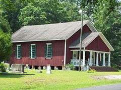
| 14 |
Hebron Church |
|
000000001977-05-16-0000May 16, 1977
(#77001227) |
10 miles (16 km) south of Conway off of U.S. Route 701
33°42′57″N 79°04′03″W / 33.715833°N 79.0675°W / 33.715833; -79.0675 (Hebron Church) |
Bucksville |
|
| 15 |
J.W. Holliday Jr. House |
|
000000001986-08-05-0000August 5, 1986
(#86002227) |
701 Laurel Street
33°50′22″N 79°03′04″W / 33.839444°N 79.051111°W / 33.839444; -79.051111 (J.W. Holliday Jr. House) |
Conway |
|
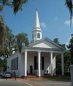
| 16 |
Kingston Presbyterian Church |
|
000000002009-09-28-0000September 28, 2009
(#08000759) |
800 3rd Avenue
33°50′10″N 79°02′43″W / 33.836111°N 79.045278°W / 33.836111; -79.045278 (Kingston Presbyterian Church) |
Conway |
|
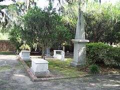
| 17 |
Kingston Presbyterian Church Cemetery |
|
000000001986-08-05-0000August 5, 1986
(#86002229) |
800 3rd Avenue
33°50′10″N 79°02′43″W / 33.836111°N 79.045278°W / 33.836111; -79.045278 (Kingston Presbyterian Church Cemetery) |
Conway |
|
| 18 |
Myrtle Beach Atlantic Coast Line Railroad Station |
|
000000002002-07-22-0000July 22, 2002
(#96001212) |
Junction of Oak Street and Broadway between Jackson Street and 8th Avenue
33°41′41″N 78°53′08″W / 33.694722°N 78.885556°W / 33.694722; -78.885556 (Myrtle Beach Atlantic Coast Line Railroad Station) |
Myrtle Beach |
|
| 19 |
Myrtle Heights-Oak Park Historic District |
|
000000001998-10-28-0000October 28, 1998
(#96001217) |
Roughly N. Ocean Boulevard between 32nd Avenue, N. and 46th Avenue, N.
33°42′52″N 78°51′14″W / 33.714444°N 78.853889°W / 33.714444; -78.853889 (Myrtle Heights-Oak Park Historic District) |
Myrtle Beach |
|
| 20 |
Ocean Forest Country Club |
|
000000001996-11-07-0000November 7, 1996
(#96001219) |
5609 Woodside Drive
33°43′47″N 78°50′36″W / 33.729722°N 78.843333°W / 33.729722; -78.843333 (Ocean Forest Country Club) |
Myrtle Beach |
|
| 21 |
Old Horry County Courthouse |
|
000000001971-04-07-0000April 7, 1971
(#71000785) |
Main Street
33°50′06″N 79°02′45″W / 33.835°N 79.045833°W / 33.835; -79.045833 (Old Horry County Courthouse) |
Conway |
|
| 22 |
Pleasant Inn |
|
000000001996-11-07-0000November 7, 1996
(#96001220) |
200 Broadway
33°41′16″N 78°53′39″W / 33.687778°N 78.894167°W / 33.687778; -78.894167 (Pleasant Inn) |
Myrtle Beach |
|
| 23 |
C.P. Quattlebaum House |
|
000000001986-08-05-0000August 5, 1986
(#86002233) |
219 Kingston Street
33°50′06″N 79°02′42″W / 33.835°N 79.045°W / 33.835; -79.045 (C.P. Quattlebaum House) |
Conway |
|
| 24 |
C.P. Quattlebaum Office |
|
000000001986-08-05-0000August 5, 1986
(#86002235) |
903 3rd Avenue
33°50′07″N 79°02′44″W / 33.835278°N 79.045556°W / 33.835278; -79.045556 (C.P. Quattlebaum Office) |
Conway |
|
| 25 |
Paul Quattlebaum House |
|
000000001986-08-05-0000August 5, 1986
(#86002231) |
225 Kingston Street
33°50′06″N 79°02′43″W / 33.835°N 79.045278°W / 33.835; -79.045278 (Paul Quattlebaum House) |
Conway |
|
| 26 |
Rainbow Court |
|
000000001996-11-07-0000November 7, 1996
(#96001221) |
405 Flagg Street
33°41′09″N 78°53′12″W / 33.685833°N 78.886667°W / 33.685833; -78.886667 (Rainbow Court) |
Myrtle Beach |
|
| 27 |
Socastee Historic District |
|
000000002002-05-22-0000May 22, 2002
(#02000558) |
South Carolina Highway 544, .5 miles (0.80 km) north of the Intracoastal Waterway
33°59′11″N 78°59′57″W / 33.986389°N 78.999167°W / 33.986389; -78.999167 (Socastee Historic District) |
Socastee |
|
| 28 |
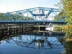
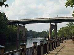
Waccamaw River Memorial Bridge |
|
000000001994-08-26-0000August 26, 1994
(#94000994) |
Main Street (U.S. Route 501) over the Waccamaw River
33°49′59″N 79°02′39″W / 33.833056°N 79.044167°W / 33.833056; -79.044167 (Waccamaw River Memorial Bridge) |
Conway |
|
| 29 |
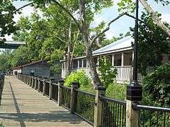
Waccamaw River Warehouse Historic District |
|
000000001986-08-05-0000August 5, 1986
(#86002269) |
Roughly Main Street between the Waccamaw River and Laurel Street
33°50′00″N 79°02′42″W / 33.833333°N 79.045°W / 33.833333; -79.045 (Waccamaw River Warehouse Historic District) |
Conway |
|
| 30 |
W. H. Winborne House |
|
000000001986-08-05-0000August 5, 1986
(#86002268) |
1300 6th Avenue
33°50′11″N 79°03′07″W / 33.836389°N 79.051944°W / 33.836389; -79.051944 (W. H. Winborne House) |
Conway |
|