Rio Terrace, Edmonton
| Rio Terrace | |
|---|---|
| Neighbourhood | |
|
Rio Terrace Location of Rio Terrace in Edmonton | |
| Coordinates: 53°30′29″N 113°34′59″W / 53.508°N 113.583°W | |
| Country |
|
| Province |
|
| City | Edmonton |
| Quadrant[1] | NW |
| Ward[1] | 5 |
| Sector[2] | Mature area |
| Area[3][4] | Jasper Place |
| Government[5] | |
| • Administrative body | Edmonton City Council |
| • Councillor | Michael Oshry |
| Area[6] | |
| • Total | 0.58 km2 (0.22 sq mi) |
| Elevation | 669 m (2,195 ft) |
| Population (2012)[7] | |
| • Total | 1,305 |
| • Density | 2,250/km2 (5,800/sq mi) |
| • Change (2009–12) |
|
| • Dwellings | 509 |
Rio Terrace is a neighbourhood in west Edmonton, Alberta, Canada. It is bounded by the Patricia Heights neighbourhood across 156 Street to the west, the Lynnwood neighbourhood across Whitemud Drive to the north, the Quesnell Heights neighbourhood across 149 Street to the east, and the North Saskatchewan River valley to the south.[8]
Rio Terrace is home to the Rio Terrace Community League.[9]
History
Development of Rio Terrace began in the 1950s, with most construction (roughly 70%) occurring during the 1960s.
Demographics
In the City of Edmonton's 2012 municipal census, Rio Terrace had a population of 1,305 living in 509 dwellings,[7] a -2.1% change from its 2009 population of 1,333.[10] With a land area of 0.58 km2 (0.22 sq mi),[6] it had a population density of 2,250 people/km2 in 2012.[6][7]
Transportation
Vehicle access to Rio Terrace is limited to the 156 Street overpass over Whitemud Drive and the 159 Street interchange along Whitemud Drive via Patricia Heights to the west.
The Edmonton Transit System provides bus service to the neighbourhood via 156 Street to the north and 76 Avenue/159 Street to the west through Patricia Heights.[11]
Education
The Rio Terrace Elementary School, operated by Edmonton Public Schools, is located within the neighbourhood.
Amenities and facilities
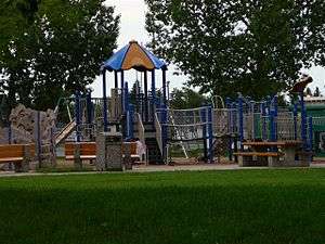
Rio Park, which includes a playground, is located on the east side of 156 Street between 76 Avenue and 76A Avenue. Rio Terrace Park is located along the south edge of the neighbourhood overlooking the North Saskatchewan River valley.
The Rio Terrace Moravian Church is located in the neighbourhood on 76 Avenue.[12]
Housing
In 2005, all of the 501 dwelling units in Rio Terrace were single-family dwellings, of which only 20 were occupied by renters.[13]
Surrounding neighbourhoods
 |
Lynnwood | Lynnwood River Valley Laurier |
Laurier Heights River Valley Laurier |
|
| Patricia Heights | |
Quesnell Heights | ||
| ||||
| | ||||
| River Valley Lessard North Westridge |
River Valley Lessard North | River Valley Laurier |
References
- 1 2 "City of Edmonton Wards & Standard Neighbourhoods" (PDF). City of Edmonton. Retrieved February 13, 2013.
- ↑ "Edmonton Developing and Planned Neighbourhoods, 2011" (PDF). City of Edmonton. Retrieved February 13, 2013.
- ↑ "The Way We Grow: Municipal Development Plan Bylaw 15100" (PDF). City of Edmonton. 2010-05-26. Retrieved February 13, 2013.
- ↑ "City of Edmonton Plans in Effect" (PDF). City of Edmonton. November 2011. Retrieved February 13, 2013.
- ↑ "City Councillors". City of Edmonton. Retrieved February 13, 2013.
- 1 2 3 "Neighbourhoods (data plus kml file)". City of Edmonton. Retrieved February 22, 2013.
- 1 2 3 "Municipal Census Results – Edmonton 2012 Census". City of Edmonton. Retrieved February 22, 2013.
- ↑ "Welcome to Edmonton Maps". City of Edmonton. Retrieved 2012-04-29.
- ↑ "Rio Terrace Community League". Rio Terrace Community League. Retrieved 2012-02-29.
- ↑ "2009 Municipal Census Results". City of Edmonton. Retrieved February 22, 2013.
- ↑ "ETS Day Map" (PDF). Edmonton Transit System. 2012-04-29. Retrieved 2012-04-29.
- ↑ "Rio Terrace Moravian Church". Rio Terrace Moravian Church. Retrieved 2012-04-30.
- ↑ "A Community Profile: Rio Terrace" (PDF). City of Edmonton. Retrieved 2012-04-29.