Twin Brooks, Edmonton
| Twin Brooks | |
|---|---|
| Neighbourhood | |
|
Artificial lake in Twin Brooks | |
|
Twin Brooks Location of Twin Brooks in Edmonton | |
| Coordinates: 53°26′28″N 113°31′44″W / 53.441°N 113.529°W | |
| Country |
|
| Province |
|
| City | Edmonton |
| Quadrant[1] | NW |
| Ward[1] | 9 |
| Sector[2] | Southwest |
| Area[3][4] | Kaskitayo |
| Government[5] | |
| • Administrative body | Edmonton City Council |
| • Councillor | Bryan Anderson |
| Area[6] | |
| • Total | 2.14 km2 (0.83 sq mi) |
| Elevation | 681 m (2,234 ft) |
| Population (2012)[7] | |
| • Total | 6,435 |
| • Density | 3,007/km2 (7,790/sq mi) |
| • Change (2009–12) |
|
| • Dwellings | 2,273 |
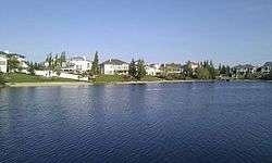
Twin Brooks is a residential neighbourhood in south Edmonton, Alberta, Canada. It is located at the confluence of the Whitemud Creek and the Blackmud Creek, hence the origin of the name Twin Brooks. An artificial lake is situated in the neighbourhood, with George P. Nicholson Elementary School located near it.
The neighbourhood is roughly triangle shaped with the Whitemud Creek on its western boundary, Blackmud Creek on the north east, and Anthony Henday Drive on the south. Access to the neighbourhood is either by 111 Street over the Blackmud Creek to the north, or from Anthony Henday Drive with interchanges at 111 Street and 119 Street.
The community has access to ETS services, with the 44 bus route going throughout the community and then up to Southgate Centre, and the 48 which extends through the northern end of the community, and continues to Blackburne. There are also plans for the LRT to be extended along 111 Street.
Twin Brooks is a newer neighbourhood. According to the 2001 Federal Census, all but a handful of the homes were constructed after 1985. Seventeen out of twenty of the homes are single-family dwellings, with most of the remainder being duplexes according to the 2005 municipal census. Almost all the occupied private dwellings are owner-occupied. The average number of people per household is three.[8]
The only commercial building in the community is an Esso gas station along 111 Street.
As of December, 2006, the City of Edmonton is planning to develop housing units near George P. Nicholson School, however this has been met with harsh criticism from local residents. Plans to build commercial and professional buildings in the same area have also been received negatively by residents. [9]
Demographics
In the City of Edmonton's 2012 municipal census, Twin Brooks had a population of 6,435 living in 2,273 dwellings,[7] a -3.9% change from its 2009 population of 6,694.[10] With a land area of 2.14 km2 (0.83 sq mi), it had a population density of 3,007 people/km2 in 2012.[6][7]
Surrounding neighbourhoods
 |
Hodgson | Blackmud Creek Ravine, Blue Quill Estates, | Blue Quill, Keheewin, Skyrattler | |
| MacTaggart Area, Magrath Heights Area | |
Bearspaw | ||
| ||||
| | ||||
| MacEwan | Blackburne |
References
- 1 2 "City of Edmonton Wards & Standard Neighbourhoods" (PDF). City of Edmonton. Retrieved February 13, 2013.
- ↑ "Edmonton Developing and Planned Neighbourhoods, 2011" (PDF). City of Edmonton. Retrieved February 13, 2013.
- ↑ "The Way We Grow: Municipal Development Plan Bylaw 15100" (PDF). City of Edmonton. 2010-05-26. Retrieved February 13, 2013.
- ↑ "City of Edmonton Plans in Effect" (PDF). City of Edmonton. November 2011. Retrieved February 13, 2013.
- ↑ "City Councillors". City of Edmonton. Retrieved February 13, 2013.
- 1 2 "Neighbourhoods (data plus kml file)". City of Edmonton. Retrieved February 13, 2013.
- 1 2 3 "Municipal Census Results – Edmonton 2012 Census". City of Edmonton. Retrieved February 22, 2013.
- ↑ http://censusdocs.edmonton.ca/DD34/MultiSource/Neighbourhood/TWIN%20BROOKS.pdf
- ↑ "Twin Brooks residents pan housing plan". Edmonton Journal. Canada.com. December 11, 2006. Retrieved November 17, 2011.
- ↑ "2009 Municipal Census Results". City of Edmonton. Retrieved February 22, 2013.