Shrewsbury, Massachusetts
| Town of Shrewsbury | ||
|---|---|---|
| Town | ||
|
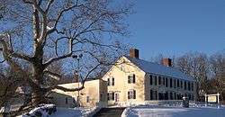
Homestead of General Artemas Ward | ||
| ||
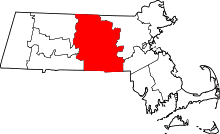
 Location in Worcester County and the state of Massachusetts. | ||
| Coordinates: 42°17′45″N 71°42′48″W / 42.29583°N 71.71333°WCoordinates: 42°17′45″N 71°42′48″W / 42.29583°N 71.71333°W | ||
| Country | United States | |
| State | Massachusetts | |
| County | Worcester | |
| Settled | 1722 | |
| Incorporated | 1727 | |
| Government | ||
| • Type | Representative town meeting | |
| • Town Manager | Daniel J. Morgado | |
| • Board of Selectmen |
James Kane Maurice DePalo Moira Miller John Lebeaux Henry Fitzgerald | |
| Area | ||
| • Total | 21.7 sq mi (56.1 km2) | |
| • Land | 20.7 sq mi (53.7 km2) | |
| • Water | 0.9 sq mi (2.4 km2) | |
| Elevation | 668 ft (204 m) | |
| Population (2010) | ||
| • Total | 35,608 | |
| • Density | 1,526.3/sq mi (589.3/km2) | |
| Time zone | Eastern (UTC-5) | |
| • Summer (DST) | Eastern (UTC-4) | |
| ZIP code | 01545 | |
| Area code(s) | 508 / 774 | |
| FIPS code | 25-61800 | |
| GNIS feature ID | 0619489 | |
| Website | www.shrewsbury-ma.gov | |

Shrewsbury is a town in Worcester County, Massachusetts, United States. Shrewsbury, unlike other surrounding towns like Grafton, Millbury, Westborough, and Northborough did not become a mill town or farming village, rather most of its 19th-century growth was due to its proximity to Worcester and visitors to Lake Quinsigamond, making it effectively a Summer resort town. The population was 35,608 according to the 2010 US Census, in nearly 12,400 households.
Incorporated in 1727, the town is governed now under the New England representative town meeting system, headed by the Town Manager and five-member elected Board of Selectmen whose duties include licensing, appointing various administrative positions, and calling a town meeting of citizens annually or whenever the need arises.
History
The Town of Shrewsbury, named for Shrewsbury, England, is a suburban community with an uneven and hilly terrain cut by a number of minor streams providing several small water power sites. Grants of land were made in what would eventually be the town beginning in 1664, with the 3,200-acre (13 km2) grant called Haynes Farm as the largest. Settlers came primarily from Sudbury and Marlborough, and the first permanent settler was Gersham Wheelock in 1720. As a town, Shrewsbury was first settled in 1722 and officially incorporated in 1727.
Townspeople created an agricultural economy with apple orchards, and by 1750, there were two stores and four taverns as well as several small industries in operation. The rapid fall of prices for agricultural goods, the shortage of hard currency, and the general economic depression following the Revolutionary War produced disastrous conditions for colonists. Shays' Rebellion in 1786 sought to close the courts to prevent debt collections and the foreclosure of mortgages. Shrewsbury became a staging area for the rebellion and the encampment of the more than 400 insurgents, before the march on the Worcester Court House.
A leather industry began in 1786 in Shrewsbury, and town farmers developed large cattle herds to support the manufacture of boots and shoes. This was followed by the establishment of gunsmithing operations in 1797, which produced rifles, shotguns and pistols and eventually cutlery. Luther Goddard began in 1809 by making brass clocks and then established a small watch factory employing a few skilled Swiss and English watchmakers. Lumbering created sawmills, and they in turn drew chair and cabinet makers, plow and wagon builders.
The development of streetcar routes in the 19th century spurred the growth of single-family housing in town. A summer resort population on Lake Quinsigamond became consumers of the market garden produce grown by town farmers. As Shrewsbury's industry was killed off by the lack of large waterpower sites and the tardy arrival of the railroad, its role as a suburb of Worcester grew more important. The town's population doubled from 1915 to 1940 as continued streetcar suburb growth brought more modern settlers into the community. Other modern developments included an increased number of lakeside cottages, ethnic clubs and recreational areas on the lake. The economy of modern Shrewsbury has been described as depending on agriculture, the resort industry and the providing of recreation and food for the population of Worcester.[1][2]
Registered Historic Places
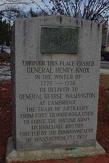
Shrewsbury is home to three current and one former Nationally Registered Historic Places:
- The Gen. Artemas Ward Homestead on Main Street
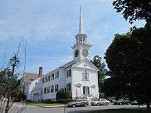
- The Shrewsbury Historic District, in the town center which includes parts of Church Road, Main Street, Prospect Street, Boylston Street, and Grafton Street
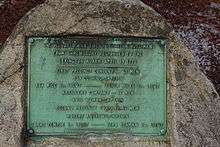
- 1767 Milestones, of which two surviving milestones are in town, along the route of the old Boston Post Road.
Geography
Shrewsbury is a suburb of Worcester, about 45 minutes from Boston and 10 minutes to downtown Worcester.
The town has a total area of 21.6 square miles (56 km2), of which, 20.7 square miles (54 km2) of it is land and 0.9 square miles (2.3 km2) of it (4.25%) is water.[3]
Adjacent cities and towns
 |
West Boylston | Boylston | | |
| Worcester | |
Northborough | ||
| ||||
| | ||||
| Grafton | Westborough |
Climate
| Climate data for Shrewsbury, Massachusetts | |||||||||||||
|---|---|---|---|---|---|---|---|---|---|---|---|---|---|
| Month | Jan | Feb | Mar | Apr | May | Jun | Jul | Aug | Sep | Oct | Nov | Dec | Year |
| Record high °F | 64 | 70 | 83 | 90 | 97 | 96 | 96 | 98 | 96 | 86 | 78 | 69 | 98 |
| Average high °F | 33 | 36 | 44 | 55 | 68 | 76 | 81 | 79 | 71 | 61 | 50 | 38 | 57.7 |
| Average low °F | 15 | 17 | 26 | 37 | 48 | 57 | 63 | 61 | 52 | 40 | 32 | 22 | 39.2 |
| Record low °F | −26 | −15 | −6 | 13 | 28 | 34 | 42 | 36 | 28 | 18 | 9 | −10 | −26 |
| Average precipitation inches | 4.20 | 3.48 | 4.27 | 4.36 | 3.94 | 3.93 | 3.80 | 4.26 | 4.11 | 4.33 | 4.46 | 3.99 | 49.13 |
| Record high °C | 18 | 21 | 28 | 32 | 36 | 36 | 36 | 37 | 36 | 30 | 26 | 21 | 37 |
| Average high °C | 1 | 2 | 7 | 13 | 20 | 24 | 27 | 26 | 22 | 16 | 10 | 3 | 14.3 |
| Average low °C | −9 | −8 | −3 | 3 | 9 | 14 | 17 | 16 | 11 | 4 | 0 | −6 | 4 |
| Record low °C | −32 | −26 | −21 | −11 | −2 | 1 | 6 | 2 | −2 | −8 | −13 | −23 | −32 |
| Average precipitation mm | 106.7 | 88.4 | 108.5 | 110.7 | 100.1 | 99.8 | 96.5 | 108.2 | 104.4 | 110 | 113.3 | 101.3 | 1,247.9 |
| Source: Weather.com[4] | |||||||||||||
Demographics
| Historical population | ||
|---|---|---|
| Year | Pop. | ±% |
| 1850 | 1,596 | — |
| 1860 | 1,558 | −2.4% |
| 1870 | 1,610 | +3.3% |
| 1880 | 1,500 | −6.8% |
| 1890 | 1,449 | −3.4% |
| 1900 | 1,626 | +12.2% |
| 1910 | 1,946 | +19.7% |
| 1920 | 3,708 | +90.5% |
| 1930 | 6,910 | +86.4% |
| 1940 | 7,586 | +9.8% |
| 1950 | 10,594 | +39.7% |
| 1960 | 16,622 | +56.9% |
| 1970 | 19,196 | +15.5% |
| 1980 | 22,674 | +18.1% |
| 1990 | 24,146 | +6.5% |
| 2000 | 31,640 | +31.0% |
| 2010 | 35,608 | +12.5% |
Source: United States Census records and Population Estimates Program data.[5][6][7][8][9][10][11][12][13][14] | ||
By the 2010 census, the population had reached 35,608.
As of the census[15] of 2000, there were 31,640 people, 12,366 households, and 8,693 families residing in the town. The population density was 1,526.3 inhabitants per square mile (589.3/km2). There were 12,696 housing units at an average density of 612.4 per square mile (236.4/km2). The racial makeup of the town was 89.12% White, 1.45% African American, 0.12% Native American, 7.61% Asian, 0.01% Pacific Islander, 0.69% from other races, and 1.00% from two or more races. Hispanic or Latino of any race were 1.59% of the population.
There were 12,366 households, out of which 34.5% had children under the age of 18 living with them, 60.1% were married couples living together, 7.5% had a female householder with no husband present, and 29.7% were non-families. 25.3% of all households were made up of individuals, and 10.5% had someone living alone who was 65 years of age or older. The average household size was 2.54, and the average family size was 3.09.
In the town the population was spread out, with 25.6% under the age of 18, 5.0% from 18 to 24, 33.4% from 25 to 44, 22.4% from 45 to 64, and 13.5% who were 65 years of age or older. The median age was 38 years. For every 100 females, there were 94.6 males. For every 100 females age 18 and over, there were 91.4 males.
The median income for a household in the town was $109,000, and the median income for a family was $124,000 (as of the 2010 census)[16]). Males had a median income of $56,259 versus $37,129 for females. The per capita income for the town was $45,570. About 3.3% of families and 4.8% of the population were below the poverty line, including 4.6% of those under age 18 and 7.6% of those age 65 or over.
Government
Town government
Shrewsbury is governed in the traditional New England style. Municipal elections are held on the first Tuesday in May.
Legislative Branch: Representative Town Meeting: 240 elected members.
Executive Branch: Five-member Board of Selectmen with three-year staggered terms, an appointed Town Manager, and other elected and appointed positions.
- Christopher Mehne (2015)
- Board of Selectmen
- Maurice M. DePalo (2017)
- Henry Fitzgerald (2017)
- James F. Kane (2018)
- John I. Lebeaux (2019)
- Moira Miller (2019)
- Erin H. Canzano (2019)
- Sandra Fryc (2017)
- Dale Magee (2019)
- John Samia (2017)
- Jon Wensky (2018)
- Library Board of Trustees
- Jack Avis (2018)
- Joan T. Barry (2017)
- Beth Casavant (2016)
- Nancy Gilbert (2016)
- Laurie Lindberg Hogan (2018)
- Clare O'Connor (2018)
- Kevin M. McKenna (2017)
- Frank Stille (2017)
- Frances Whitney (2016)
- Appointed officials (selected)
- Town Manager: Daniel J. Morgado
- Town Clerk: Sandra Wright
- Chief of Police: James J. Hester, Jr.
- Fire Chief: James M. Vuona
- Superintendent: Joseph Sawyer
Source: "Town Officials". Town of Shrewsbury.
Various other boards, committees, and commissions round out the variety of services provided to residents, including water, health, fire, ambulance, police, education, recreation, etc.
County, state, and federal government
| County-level state agency heads | |
|---|---|
| Clerk of Courts: | Dennis P. McManus (D) |
| District Attorney: | Joseph D. Early, Jr. (D) |
| Register of Deeds: | Anthony J. Vigliotti (D) |
| Register of Probate: | Stephanie K. Fattman (R) |
| County Sheriff: | Lew Evangelidis (R) |
| State government | |
| State Representative(s): | Hannah Kane (R-11th Worcester district) |
| State Senator(s): | Michael O. Moore (D–2nd Worcester district) |
| Governor's Councilor(s): | Jen Caissie (R) |
| Federal government | |
| U.S. Representative(s): | James McGovern (D–Massachusetts's 2nd congressional district) |
| U.S. Senators: | Elizabeth Warren (D), Ed Markey (D) |
Education


Shrewsbury Public Schools is the public school district in the town. Schools in the district include Shrewsbury High School, two middle schools, four elementary schools, one early childhood school for kindergarten and grade one, and one preschool.[17] Non-public schools in town include Shrewsbury Montessori, a private school offering programs for pre-K through grade 6;[18] St. Mary's School, a Catholic parochial school for pre-K through grade 8;[19] and Saint John’s High School, a private Xaverian Brothers sponsored high school.
Library

The Shrewsbury Public Library was established in 1872.[20][21] In fiscal year 2008, the town of Shrewsbury spent 1.4% ($1,164,563) of its budget on its public library — about $34 per town resident.[22] Following the 1978 library expansion project, another expansion was needed. In 2004 and 2010, officials completed research showing inadequate space, poorly maintained roofs and heating/cooling systems, lack of handicap accessibility, and a growing demand for library services. In 2010, a project was proposed that would create a new 42,000-square-foot (3,900 m2) facility for a total of approximately $19 million.[23] The main library closed to enable construction of the new building and opened in temporary accommodation at 214 Lake Street on 26 October 2014. As of June 15, 2016, construction on the expansion project was substantially complete and work on punch list items was ongoing.[24]
Notable people
- Richard T. Antoun (1932–2009), Professor Emeritus of Anthropology at Binghamton University; stabbed to death by a student
- Kenneth S. Apfel (b. 1948), 13th Commissioner of Social Security
- Lillian Asplund (1906–2006), last American survivor of the Titanic sinking
- Mike Birbiglia (b. 1978), stand-up comedian
- Peter I. Blute (b. 1956), Congressman representing Massachusetts's 3rd congressional district from 1993 to 1997
- Min Chueh Chang (1908–1991), co-inventor of the combined oral contraceptive pill and in-vitro fertilization
- Ralph Earl (1751–1801), American painter and landscape artist, known for his portrait of Roger Sherman
- Gardner Howe (1759–1854), Vermont state legislator
- Jonah Howe (1749–1826), Massachusetts state legislator
- Luke Knowlton (1738-1810), founder of Newfane, Vermont, Justice of the Vermont Supreme Court, member of the Vermont House of Representatives
- Jesse Lauriston Livermore (1877–1940), famed for making and losing several multimillion-dollar fortunes as a stock speculator
- Gregory Mcdonald (1937–2008), author of the Fletch series of novels
- Craig Mello (b. 1960), 2006 Nobel Prize winner in Physiology or Medicine
- Francis Patrick O'Connor (1927–2007), Massachusetts Supreme Court Judge
- Robert Allan Ridley Parker (b. 1936), director of the NASA Management Office at the Jet Propulsion Laboratory
- Charlie Pierce (b. 1953), American writer/journalist, and panelist on NPR's Wait Wait... Don't Tell Me
- Karyn Polito (b. 1966), Massachusetts state legislator and 72nd Lieutenant Governor of Massachusetts
- Artemas Ward (1727–1800), American Major General in the American Revolutionary War and a Congressman from Massachusetts, often characterized as the runner-up for George Washington's post
Notable businesses

- The Hebert Candy Mansion, where white chocolate was first produced in the United States.
- The now-defunct Worcester Foundation for Experimental Biology, the renowned research facility where the combined oral contraceptive pill was first developed. The campus is now the Hoagland-Pincus Conference Center of the University of Massachusetts Medical School.
- The now-defunct Spag's, the original all-purpose store, which predated Costco, Walmart and other similar outlets. Spag's was noted for its unorthodox inventory and discount prices. Upon the death of its founder, Anthony Borgatti, Spag's succumbed to the competition of the modern megastore and the challenges of handing over the reins to a new generation and was acquired in 2002 by Building 19. The location became Spags 19, and in 2004 the store was converted to Building 19's format (it is now closed). The site is being developed as Lakeview Commons and Wholefoods, Starbucks and Burtons Grill have announced plans to open here.
- The now-defunct White City amusement park, now the site of a shopping plaza. Petco relocated from the opposite side of Route 9 to this plaza in Spring 2015.
References

- ↑ Massachusetts Department of Housing and Community Development
- ↑ Narrative supplied by community and based on information provided by the Massachusetts Historical Commission.
- ↑ According to the United States Census Bureau
- ↑ "Weather.com".
- ↑ "TOTAL POPULATION (P1), 2010 Census Summary File 1". American FactFinder, All County Subdivisions within Massachusetts. United States Census Bureau. 2010.
- ↑ "Massachusetts by Place and County Subdivision - GCT-T1. Population Estimates". United States Census Bureau. Retrieved July 12, 2011.
- ↑ "1990 Census of Population, General Population Characteristics: Massachusetts" (PDF). US Census Bureau. December 1990. Table 76: General Characteristics of Persons, Households, and Families: 1990. 1990 CP-1-23. Retrieved July 12, 2011.
- ↑ "1980 Census of the Population, Number of Inhabitants: Massachusetts" (PDF). US Census Bureau. December 1981. Table 4. Populations of County Subdivisions: 1960 to 1980. PC80-1-A23. Retrieved July 12, 2011.
- ↑ "1950 Census of Population" (PDF). Bureau of the Census. 1952. Section 6, Pages 21-10 and 21-11, Massachusetts Table 6. Population of Counties by Minor Civil Divisions: 1930 to 1950. Retrieved July 12, 2011.
- ↑ "1920 Census of Population" (PDF). Bureau of the Census. Number of Inhabitants, by Counties and Minor Civil Divisions. Pages 21-5 through 21-7. Massachusetts Table 2. Population of Counties by Minor Civil Divisions: 1920, 1910, and 1920. Retrieved July 12, 2011.
- ↑ "1890 Census of the Population" (PDF). Department of the Interior, Census Office. Pages 179 through 182. Massachusetts Table 5. Population of States and Territories by Minor Civil Divisions: 1880 and 1890. Retrieved July 12, 2011.
- ↑ "1870 Census of the Population" (PDF). Department of the Interior, Census Office. 1872. Pages 217 through 220. Table IX. Population of Minor Civil Divisions, &c. Massachusetts. Retrieved July 12, 2011.
- ↑ "1860 Census" (PDF). Department of the Interior, Census Office. 1864. Pages 220 through 226. State of Massachusetts Table No. 3. Populations of Cities, Towns, &c. Retrieved July 12, 2011.
- ↑ "1850 Census" (PDF). Department of the Interior, Census Office. 1854. Pages 338 through 393. Populations of Cities, Towns, &c. Retrieved July 12, 2011.
- ↑ "American FactFinder". United States Census Bureau. Retrieved 2008-01-31.
- ↑ Shrewsbury town United States Census Bureau
- ↑ http://schools.shrewsburyma.gov/
- ↑ http://shrewsburymontessori.org/about-us/
- ↑ http://www.stmarysparish.org/school/AboutUs.aspx
- ↑ Tillinghast, C.B. (1891). The free public libraries of Massachusetts. 1st Report of the Free Public Library Commission of Massachusetts. Boston: Wright & Potter.
- ↑ http://www.shrewsbury-ma.gov/department/index.php?fDD=17-0 Retrieved November 10, 2010
- ↑ July 1, 2007 through June 30, 2008; cf. The FY2008 Municipal Pie: What’s Your Share?, Commonwealth of Massachusetts, Board of Library Commissioners. Boston: 2009, Retrieved August 4, 2010
- ↑ Campaign4ShrewsburyLibrary.net. Retrieved 28 August 2011.
- ↑ Minutes, Board of Library Trustees meeting, June 15, 2016
External links
| Wikimedia Commons has media related to Shrewsbury, Massachusetts. |
- Town of Shrewsbury Official Website
 Shrewsbury travel guide from Wikivoyage
- Shrewsbury Historical Society