Aiti
| Aiti | |
|---|---|
|
A general view of Aiti | |
 Aiti | |
|
Location within Corsica region 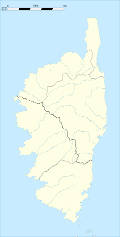 Aiti | |
| Coordinates: 42°24′00″N 9°14′41″E / 42.4°N 9.2447°ECoordinates: 42°24′00″N 9°14′41″E / 42.4°N 9.2447°E | |
| Country | France |
| Region | Corsica |
| Department | Haute-Corse |
| Arrondissement | Corte |
| Canton | Bustanico |
| Intercommunality | Vallée de Casaluna |
| Government | |
| • Mayor (2001–2020) | Gérard Orsoni |
| Area1 | 12.17 km2 (4.70 sq mi) |
| Population (2009)2 | 32 |
| • Density | 2.6/km2 (6.8/sq mi) |
| Time zone | CET (UTC+1) |
| • Summer (DST) | CEST (UTC+2) |
| INSEE/Postal code | 2B003 / 20244 |
| Elevation | 240–1,120 m (790–3,670 ft) |
|
1 French Land Register data, which excludes lakes, ponds, glaciers > 1 km² (0.386 sq mi or 247 acres) and river estuaries. 2 Population without double counting: residents of multiple communes (e.g., students and military personnel) only counted once. | |

Aiti (in Corsican Àiti, pronounced [ˈaː.i.di]) is a French commune in the Haute-Corse department of France on the island of Corsica.
The inhabitants of the commune are known as Aïtinchi.[1]
Geography
Aiti is some 15 km north of Corte and about 25 km inland from the east coast of Corsica. The Highway N193 from Corte goes north passing near the eastern border of the commune however the commune can only be accessed from this side by the D39 from Francardo a tortuous and circuitous road. The commune can also be accessed from the eastern side from San-Lorenzo on the Highway D39 which has a small connecting road across a bridge to the D39 road which enters the commune from the south and is another tortuous and circuitous route to the village of Aiti. Other than some short mountain access roads there are no other roads in the commune.[2]
Relief
Aiti occupies the northern part of the mountain chain in the west of the massif of Monte San Petrone (1,767 m) which is separated by the Casaluna Valley.
The commune lies "below the hill" (Cismonte in Corsican), or "Corsican Shale" in the north-east of the island along the edge of the Cap Corse shale which continues to the San Petrone mountains and ends south of Castagnicia. These mountains are a block of lustrous shale from the Tertiary period during the uplift of the Alps on the Hercynian bedrock at the end of the Paleozoic era.
The highest point in the commune is the Cima a l'Orzale (1,121 m) south of the town and the lowest point is next to the Golo river (238 m) to the north-west.
The commune is mountainous with the hills of Castagnicia to the west. It occupies a small portion of a low-lying area called "Cuvette de Ponte Leccia" (Ponte Leccia Basin) which is one of a series of central low-lying areas stretching from L'Île-Rousse to Solenzara through Ponte Leccia, Corte, and Cateraggio. It includes many small valleys where streams flow to the Golo or the Casaluna.
Hydrography
The western border of the commune is the Callasima River which flows north to join the Golo River near Ponte-Leccia.[3]
Several streams run through the commune, emerging from either side of the valley. The main streams are Poggie, Coticcio (fed by the Campo and Riduri), and Fossa Ceca.
Neighbouring Communes and Villages
 |
Piedigriggio | Ponte Leccia | Gavignano | |
| Francardo | |
Saliceto | ||
| ||||
| | ||||
| Omessa | Lano | San-Lorenzo |
Administration
List of Successive Mayors of Aiti[4]
| From | To | Name | Party | Position |
|---|---|---|---|---|
| 2001 | 2020 | Gerard Orsoni |
(Not all data is known)
Demography
In 2009, the commune had 32 inhabitants. The evolution of the number of inhabitants is known through the population censuses conducted in the town since 1793. From the 21st century, a census of municipalities with fewer than 10,000 inhabitants is held every five years, unlike larger towns that have a sample survey every year.[Note 1]
| 1793 | 1800 | 1806 | 1821 | 1831 | 1836 | 1841 | 1846 | 1851 |
|---|---|---|---|---|---|---|---|---|
| - | 297 | 311 | 294 | 356 | 332 | 340 | 314 | 304 |
| 1856 | 1861 | 1866 | 1872 | 1876 | 1881 | 1886 | 1891 | 1896 |
|---|---|---|---|---|---|---|---|---|
| 293 | 284 | 282 | 277 | 273 | 322 | 306 | 239 | 250 |
| 1901 | 1906 | 1911 | 1921 | 1926 | 1931 | 1936 | 1946 | 1954 |
|---|---|---|---|---|---|---|---|---|
| 231 | 218 | 200 | 256 | 234 | 204 | 209 | 143 | 150 |
| 1962 | 1968 | 1975 | 1982 | 1990 | 1999 | 2006 | 2009 | - |
|---|---|---|---|---|---|---|---|---|
| 66 | 59 | 32 | 16 | 26 | 24 | 29 | 32 | - |
Sources : Ldh/EHESS/Cassini until 1962, INSEE database from 1968 (population without double counting and municipal population from 2006)


-

Aiti
-

The Church of Saint-Stephen
-

The area south of the village
-

Facade of the Church of Saint-Stephen
See also
External links
- Aiti on Mapquest
- Aiti on Lion1906
- Aiti on Google Maps
- Aiti on Géoportail, National Geographic Institute (IGN) website (French)
- Aiti on the INSEE website (French)
- INSEE (French)
Notes and references
Notes
- ↑ At the beginning of the 21st century, the methods of identification have been modified by law No. 2002-276 of 27 February 2002 , the so-called "law of local democracy" and in particular Title V "census operations" which allow, after a transitional period running from 2004 to 2008, the annual publication of the legal population of the different French administrative districts. For municipalities with a population greater than 10,000 inhabitants, a sample survey is conducted annually, the entire territory of these municipalities is taken into account at the end of the period of five years. The first "legal population" after 1999 under this new law came into force on 1 January 2009 and was based on the census of 2006.
References
- ↑ Inhabitants of Haute-Corse (French)
- ↑ Google Maps
- ↑ Corsica River Map
- ↑ List of Mayors of France (French)
| Wikimedia Commons has media related to Aiti. |