San-Gavino-di-Tenda
| San-Gavino-di-Tenda | |
|---|---|
|
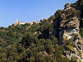
A general view of San-Gavino-di-Tenda | |
 San-Gavino-di-Tenda | |
|
Location within Corsica region  San-Gavino-di-Tenda | |
| Coordinates: 42°35′59″N 9°16′05″E / 42.5997°N 9.2681°ECoordinates: 42°35′59″N 9°16′05″E / 42.5997°N 9.2681°E | |
| Country | France |
| Region | Corsica |
| Department | Haute-Corse |
| Arrondissement | Calvi |
| Canton | Haut-Nebbio |
| Intercommunality | Nebbiu |
| Government | |
| • Mayor (2008–2014) | François Grossi |
| Area1 | 50.44 km2 (19.47 sq mi) |
| Population (2008)2 | 53 |
| • Density | 1.1/km2 (2.7/sq mi) |
| Time zone | CET (UTC+1) |
| • Summer (DST) | CEST (UTC+2) |
| INSEE/Postal code | 2B301 / 20246 |
| Elevation |
0–1,426 m (0–4,678 ft) (avg. 340 m or 1,120 ft) |
|
1 French Land Register data, which excludes lakes, ponds, glaciers > 1 km² (0.386 sq mi or 247 acres) and river estuaries. 2 Population without double counting: residents of multiple communes (e.g., students and military personnel) only counted once. | |
San-Gavino-di-Tenda is a commune in the Haute-Corse department of France on the island of Corsica.
Population
| Historical population | ||
|---|---|---|
| Year | Pop. | ±% |
| 1962 | 54 | — |
| 1968 | 97 | +79.6% |
| 1975 | 86 | −11.3% |
| 1982 | 70 | −18.6% |
| 1990 | 47 | −32.9% |
| 1999 | 56 | +19.1% |
| 2008 | 53 | −5.4% |

The village
See also
References
| Wikimedia Commons has media related to San-Gavino-di-Tenda. |
This article is issued from Wikipedia - version of the 4/28/2016. The text is available under the Creative Commons Attribution/Share Alike but additional terms may apply for the media files.