Aspermont, Texas
| Aspermont, Texas | |
|---|---|
| Town | |
|
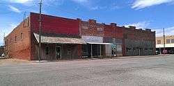
A row of buildings south of the Stonewall County Courthouse in Aspermont, Texas. | |
 Location of Aspermont, Texas | |
 | |
| Coordinates: 33°8′21″N 100°13′42″W / 33.13917°N 100.22833°WCoordinates: 33°8′21″N 100°13′42″W / 33.13917°N 100.22833°W | |
| Country | United States |
| State | Texas |
| County | Stonewall |
| Area | |
| • Total | 2.1 sq mi (5.4 km2) |
| • Land | 2.1 sq mi (5.4 km2) |
| • Water | 0.0 sq mi (0.0 km2) |
| Elevation | 1,781 ft (543 m) |
| Population (2000) | |
| • Total | 1,021 |
| • Density | 493.2/sq mi (190.4/km2) |
| Time zone | Central (CST) (UTC-6) |
| • Summer (DST) | CDT (UTC-5) |
| ZIP code | 79502 |
| Area code(s) | 940 |
| FIPS code | 48-04408[1] |
| GNIS feature ID | 1372350[2] |
Aspermont is a town in the U.S. state of Texas, and is the county seat of Stonewall County. [3] The population was 919 at the 2010 census.
History
The town was established in 1889.[4] Aspermont means "rough mountain" in Latin, and is probably a reference to the nearby Double Mountains. The city was founded by A. L. Rhomberg of Swiss-Austrian descent, who might have been a descendant of the noble family Aspermont from Graubünden, which is known to have relocated to Dornbirn in the Austrian part of the Rhine valley and changed the name to Rhomberg. Marshall Formby, later a Texas state senator, operated the Aspermont Star weekly newspaper in the middle 1930s. The paper is now known as the Stonewall County Courier.
-
Stonewall County Courthouse in Aspermont
-
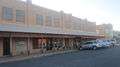
Downtown Aspermont
-
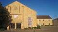
First Baptist Church of Aspermont
Geography
According to the United States Census Bureau, the town has a total area of 2.1 square miles (5.4 km²), all of it land.
Demographics
| Historical population | |||
|---|---|---|---|
| Census | Pop. | %± | |
| 1890 | 205 | — | |
| 1920 | 436 | — | |
| 1930 | 769 | 76.4% | |
| 1940 | 1,041 | 35.4% | |
| 1950 | 1,062 | 2.0% | |
| 1960 | 1,286 | 21.1% | |
| 1970 | 1,198 | −6.8% | |
| 1980 | 1,357 | 13.3% | |
| 1990 | 1,214 | −10.5% | |
| 2000 | 1,021 | −15.9% | |
| 2010 | 919 | −10.0% | |
| Est. 2015 | 868 | [5] | −5.5% |
As of the census[1] of 2000, there were 1,021 people, 418 households, and 282 families residing in the town. The population density was 493.2 people per square mile (190.4/km²). There were 507 housing units at an average density of 244.9 per square mile (94.6/km²). The racial makeup of the town was 85.99% White, 4.31% African American, 0.10% Native American, 0.39% Asian, 7.25% from other races, and 1.96% from two or more races. Hispanic or Latino of any race were 13.12% of the population.
There were 418 households out of which 27.5% had children under the age of 18 living with them, 52.4% were married couples living together, 11.7% had a female householder with no husband present, and 32.3% were non-families. 30.1% of all households were made up of individuals and 15.6% had someone living alone who was 65 years of age or older. The average household size was 2.34 and the average family size was 2.90.
In the town the population was spread out with 23.4% under the age of 18, 7.2% from 18 to 24, 23.4% from 25 to 44, 23.5% from 45 to 64, and 22.4% who were 65 years of age or older. The median age was 41 years. For every 100 females there were 82.6 males. For every 100 females age 18 and over, there were 81.0 males.
The median income for a household in the town was $25,893, and the median income for a family was $31,172. Males had a median income of $24,904 versus $13,971 for females. The per capita income for the town was $14,060. About 17.1% of families and 22.3% of the population were below the poverty line, including 37.5% of those under age 18 and 11.5% of those age 65 or over.
Education
The Town of Aspermont is served by the Aspermont Independent School District and home to the Aspermont High School Hornets.
Climate
| Climate data for Aspermont, Texas (1981–2010) | |||||||||||||
|---|---|---|---|---|---|---|---|---|---|---|---|---|---|
| Month | Jan | Feb | Mar | Apr | May | Jun | Jul | Aug | Sep | Oct | Nov | Dec | Year |
| Average high °F (°C) | 55.9 (13.3) |
59.8 (15.4) |
68.4 (20.2) |
77.8 (25.4) |
85.9 (29.9) |
92.7 (33.7) |
96.5 (35.8) |
95.9 (35.5) |
87.8 (31) |
77.8 (25.4) |
65.8 (18.8) |
56.1 (13.4) |
76.7 (24.8) |
| Average low °F (°C) | 29.2 (−1.6) |
32.4 (0.2) |
39.7 (4.3) |
48.0 (8.9) |
58.1 (14.5) |
66.5 (19.2) |
70.2 (21.2) |
69.5 (20.8) |
61.4 (16.3) |
50.5 (10.3) |
38.4 (3.6) |
29.5 (−1.4) |
49.4 (9.7) |
| Average precipitation inches (mm) | 1.00 (25.4) |
1.40 (35.6) |
1.64 (41.7) |
1.88 (47.8) |
3.18 (80.8) |
3.51 (89.2) |
1.98 (50.3) |
2.75 (69.9) |
2.10 (53.3) |
2.23 (56.6) |
1.19 (30.2) |
1.05 (26.7) |
23.91 (607.3) |
| Average snowfall inches (cm) | 1.2 (3) |
0.8 (2) |
0.0 (0) |
0.1 (0.3) |
0.0 (0) |
0.0 (0) |
0.0 (0) |
0.0 (0) |
0.0 (0) |
0.0 (0) |
0.8 (2) |
0.4 (1) |
3.2 (8.1) |
| Source: NOAA[7] | |||||||||||||
References
- 1 2 "American FactFinder". United States Census Bureau. Archived from the original on 2013-09-11. Retrieved 2008-01-31.
- ↑ "US Board on Geographic Names". United States Geological Survey. 2007-10-25. Retrieved 2008-01-31.
- ↑ "Find a County". National Association of Counties. Archived from the original on 2011-05-31. Retrieved 2011-06-07.
- ↑ "Aspermont, Texas". Texas State Historical Association. Retrieved 2012-02-06.
- ↑ "Annual Estimates of the Resident Population for Incorporated Places: April 1, 2010 to July 1, 2015". Retrieved July 2, 2016.
- ↑ "Census of Population and Housing". Census.gov. Archived from the original on May 11, 2015. Retrieved June 4, 2015.
- ↑ "NOWData - NOAA Online Weather Data". National Oceanic and Atmospheric Administration. Retrieved May 6, 2013.
External links
- Aspermont Star newspaper hosted by the Portal to Texas History.
Municipalities and communities of Stonewall County, Texas, United States | ||
|---|---|---|
| Town | 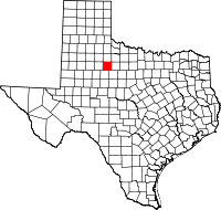 | |
| Unincorporated communities | ||
| Ghost town | ||