Farwell, Texas
| Farwell, Texas | |
|---|---|
| City | |
|
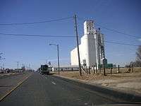
Grain storage in Farwell, Texas | |
 Location of Farwell, Texas | |
 | |
| Coordinates: 34°22′59″N 103°2′18″W / 34.38306°N 103.03833°WCoordinates: 34°22′59″N 103°2′18″W / 34.38306°N 103.03833°W | |
| Country | United States |
| State | Texas |
| County | Parmer |
| Area | |
| • Total | 0.8 sq mi (2.1 km2) |
| • Land | 0.8 sq mi (2.1 km2) |
| • Water | 0.0 sq mi (0.0 km2) |
| Elevation | 4,144 ft (1,263 m) |
| Population (2000) | |
| • Total | 1,364 |
| • Density | 1,666.8/sq mi (643.5/km2) |
| Time zone | Central (CST) (UTC-6) |
| • Summer (DST) | CDT (UTC-5) |
| ZIP code | 79325 |
| Area code(s) | 806 |
| FIPS code | 48-25548[1] |
| GNIS feature ID | 1357260[2] |
Farwell is a city in and the county seat of Parmer County, Texas, United States.[3] As of the census[1] of 2000, there were 1,364 people. The city is located on the Texas-New Mexico border with the town of Texico, New Mexico across the border.
History
The early years of Farwell were tied to the legendary XIT Ranch, which covered parts of twelve Texas counties prior to its closing in the 1940s.
One of the few obelisks marking the Ozark Trail (auto trail) is located at Farwell City Park. The lighted structure was unveiled in 2010 at a cost of $11,000. The Ozark Trail extended from St. Louis, Missouri, to Santa Fe, New Mexico. Other such markers are in Wellington, Dimmitt, and Tulia, Texas.[4]
For years there has been a simmering dispute over which state Farwell is lawfully a part of: Texas or New Mexico? The straight north-south border between the two states was originally defined as the 103rd meridian, but the 1859 survey that was supposed to mark that boundary mistakenly set the border between 2.29 and 3.77 miles too far west of that line, making the current towns of Farwell, Texline and a part of Glenrio appear to be within the State of Texas. New Mexico's short border with Oklahoma, in contrast, was surveyed on the correct meridian. New Mexico's draft constitution in 1910 stated that the border is on the 103rd meridian as intended. The disputed strip, hundreds of miles long, includes parts of valuable oilfields of the Permian Basin. A bill was passed in the New Mexico Senate to fund and file a lawsuit in the U.S. Supreme Court to recover the strip from Texas, but the bill did not become law. Today, land in the strip is included in Texas land surveys and the land and towns for all purposes are taxed and governed by The State of Texas.[5]
Geography
Farwell lies on the level plains of the Llano Estacado at 34°22′59″N 103°2′18″W / 34.38306°N 103.03833°W (34.382919, -103.038339).[6] According to the United States Census Bureau, the city has a total area of 0.8 square miles (2.1 km2), all of it land.
Farwell is located 10 miles (16 km) east of Clovis, New Mexico and 88 miles (142 km) northwest of Lubbock, Texas. 95 miles (152.888 km) southwest of Amarillo, Texas.
Demographics
| Historical population | |||
|---|---|---|---|
| Census | Pop. | %± | |
| 1960 | 1,009 | — | |
| 1970 | 1,185 | 17.4% | |
| 1980 | 1,354 | 14.3% | |
| 1990 | 1,373 | 1.4% | |
| 2000 | 1,364 | −0.7% | |
| 2010 | 1,363 | −0.1% | |
| Est. 2015 | 1,311 | [7] | −3.8% |
As of the census[1] of 2000, there were 1,364 people, 499 households, and 346 families residing in the city. The population density was 1,666.8 people per square mile (642.2/km²). There were 560 housing units at an average density of 684.3 per square mile (263.7/km²). The racial makeup of the city was 75.00% White, 0.44% African American, 0.51% Native American, 1.03% Asian, 20.82% from other races, and 2.20% from two or more races. Hispanic or Latino of any race were 31.96% of the population.
There were 499 households out of which 34.9% had children under the age of 18 living with them, 56.9% were married couples living together, 9.6% had a female householder with no husband present, and 30.5% were non-families. 28.1% of all households were made up of individuals and 17.2% had someone living alone who was 65 years of age or older. The average household size was 2.58 and the average family size was 3.18.
In the city the population was spread out with 27.9% under the age of 18, 6.8% from 18 to 24, 24.8% from 25 to 44, 20.6% from 45 to 64, and 19.9% who were 65 years of age or older. The median age was 39 years. For every 100 females there were 88.7 males. For every 100 females age 18 and over, there were 80.9 males.
The median income for a household in the city was $29,808, and the median income for a family was $34,676. Males had a median income of $27,448 versus $21,181 for females. The per capita income for the city was $15,875. About 13.9% of families and 16.7% of the population were below the poverty line, including 22.8% of those under age 18 and 13.7% of those age 65 or over.
Education
The City of Farwell is served by the Farwell Independent School District.
The Farwell Lady Blue won their first Class 2A State Championship in 2002, a 47-35 victory against Brock in front of 8,870 fans at the Frank Erwin Center at the University of Texas at Austin. In 2001, the first year the Lady Blue had competed in Class 2A, the Lady Blue's inexperience in big games showed as it lost a two-point semifinal match-up against Salado. In 2002, the Lady Blue survived its non-district schedule, finishing with a more-than-respectable 14-6 record. Farwell finished second in District 4-2A, losing only twice to seventh-ranked Hale Center by a combined six points. While the girls team had never traveled to Austin for the basketball tournament, the Farwell Steers (boys) advanced there in 1989. Farwell's girls' athletic teams were originally known as the Steerettes but now have the mascot Lady Blue after the school's official colors. The Lady Blue cross country team has made the trip to state three seasons in a row.
Notable people
- Charlie Sugartime Phillips, singer, songwriter [9]
- Addie Peed Swearingen, philanthropist
Gallery
-
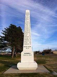
Obelisk commemorating Ozark Trail (auto trail) in Farwell, Texas
-

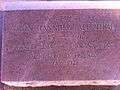
Plaque on Ozark Trail in Farwell, TX
-
Monument honoring early pioneer in Farwell, TX
-
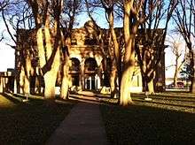
Parmer County courthouse in Farwell
-
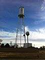
Two water towers in Farwell
-
Monument commemorating the Farwell brothers for whom the town is named, founders of the XIT Ranch
-

Spanish poster in Farwell, evidence of growing Spanish-speaking population
References
- 1 2 3 "American FactFinder". United States Census Bureau. Retrieved 2008-01-31.
- ↑ "US Board on Geographic Names". United States Geological Survey. 2007-10-25. Retrieved 2008-01-31.
- ↑ "Find a County". National Association of Counties. Retrieved 2011-06-07.
- ↑ Will Anderson of State Line Tribune in Farwell, "Resurrection of the Ozark Trail Marker in Farwell, Texas," West Texas Historical Association annual meeting, Lubbock, Texas, April 2, 2011
- ↑ Daniel Gertson. "Border War Brewing?". Retrieved 2016-09-24.
- ↑ "US Gazetteer files: 2010, 2000, and 1990". United States Census Bureau. 2011-02-12. Retrieved 2011-04-23.
- ↑ "Annual Estimates of the Resident Population for Incorporated Places: April 1, 2010 to July 1, 2015". Retrieved July 2, 2016.
- ↑ "Census of Population and Housing". Census.gov. Retrieved June 4, 2015.
- ↑ Hacker, Bobby (March). "Charlie "Sugartime" Phillips". American Music Magazine. 126 (2001): 38. Check date values in:
|date=(help)
External links
Municipalities and communities of Parmer County, Texas, United States | ||
|---|---|---|
| Cities | 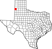 | |
| Unincorporated community | ||