Belton, Texas
| Belton, Texas | |
|---|---|
| City | |
|
Downtown Belton near Bell County Courthouse | |
| Nickname(s): Beltown | |
 Location of Belton, Texas | |
 | |
| Coordinates: 31°3′32″N 97°27′48″W / 31.05889°N 97.46333°WCoordinates: 31°3′32″N 97°27′48″W / 31.05889°N 97.46333°W | |
| Country | United States |
| State | Texas |
| County | Bell |
| Area | |
| • Total | 20.0 sq mi (51.7 km2) |
| • Land | 18.9 sq mi (49.0 km2) |
| • Water | 1.0 sq mi (2.6 km2) |
| Elevation | 509 ft (155 m) |
| Population (2010) | |
| • Total | 18,216 |
| • Density | 962/sq mi (371.6/km2) |
| Time zone | Central (CST) (UTC-6) |
| • Summer (DST) | CDT (UTC-5) |
| ZIP code | 76513 |
| Area code(s) | 254 |
| FIPS code | 48-07492[1] |
| GNIS feature ID | 1351858[2] |
| Website |
www |

The City of Belton -- county seat of Bell County, Texas, United States[3] -- is located in Central Texas. The population was 20,547 in 2015 according to a US Census Estimate.[4] Belton is located in the center of the Killeen – Temple – Fort Hood metropolitan area. As of 2015 the metro region had a population of 450,051.[5]
Geography
Belton is located near the center of Bell County at 31°3′32″N 97°27′48″W / 31.05889°N 97.46333°W (31.058904, -97.463382).[6] It is bordered to the northeast by the Leon River, across which is the city of Temple. Nolan Creek, a tributary of the Leon, runs through the center of Belton. The city limits extend south along Interstate 35 across the Lampasas River nearly to Salado.
By Interstate 35 it is 42 miles (68 km) north to Waco and 60 miles (97 km) south to Austin. U.S. Route 190 leads west from Belton 16 miles (26 km) to Killeen.
According to the United States Census Bureau, the city has a total area of 20.0 square miles (51.7 km2), of which 18.9 square miles (49.0 km2) is land and 1.0 square mile (2.6 km2), or 5.08%, is water.[7]
History
Belton was platted in 1850 with the name of Nolandville. It was given its current name in 1851, named after Texas' governor, Peter Hansborough Bell. As the county seat of the like-named Bell County, the town seemed destined for growth. In 1868, Martha McWhirter, a prominent figure in Belton's nonsectarian Union Sunday School, created the only Texas women's communes of the 1800s. Thomas W. Cochran of H.M Cook and Company, which later became Cochran, Blair and Potts, once threatened fisticuffs against Martha McWhirter in the middle of East Central Avenue, yelling her down and telling her that if she wished to live like a man, then by God she should be prepared to fight like one in the streets. 15 of her fellow commune members ran out into the street behind her with pitchforks and other farm implements. Mr. Cochran was humiliated and forced to back down, and remained a mortal enemy of McWhirter from that moment on, and forced the commune to flee to Maryland in 1899 when he refused to sell dry goods to the commune's hotel, Central Hotel.[8] The 1880s marked the town's brightest age, with the building of the courthouse, Baylor Female College buildings, and a "railroad war" in which, by 1881, Belton was bypassed by the railroad which built Temple as the local junction and depot town. In 1913 the city experienced a major flood,[9] leading to the naming of Yettie Polk Park, for Mrs. Yettie Tobler Polk, one of those who died.[10] The town began to thrive again following the creation of Fort Hood in 1942.
Demographics
| Historical population | |||
|---|---|---|---|
| Census | Pop. | %± | |
| 1870 | 281 | — | |
| 1880 | 1,797 | 539.5% | |
| 1890 | 3,000 | 66.9% | |
| 1900 | 3,700 | 23.3% | |
| 1910 | 4,164 | 12.5% | |
| 1920 | 5,098 | 22.4% | |
| 1930 | 3,779 | −25.9% | |
| 1940 | 3,572 | −5.5% | |
| 1950 | 6,246 | 74.9% | |
| 1960 | 8,163 | 30.7% | |
| 1970 | 8,696 | 6.5% | |
| 1980 | 10,660 | 22.6% | |
| 1990 | 12,476 | 17.0% | |
| 2000 | 14,623 | 17.2% | |
| 2010 | 18,216 | 24.6% | |
| Est. 2015 | 20,547 | [4] | 12.8% |
As of the census[1] of 2000, there were 14,623 people, 4,742 households, and 3,319 families residing in the city. The population density was 1,171.3 people per square mile (452.4/km²). There were 5,089 housing units at an average density of 407.6 per square mile (157.4/km²). The racial makeup of the city was 72.67% White, 8.10% African American, 0.64% Native American, 0.95% Asian, 0.10% Pacific Islander, 14.83% from other races, and 2.71% from two or more races. Hispanic or Latino of any race were 25.13% of the population.
There were 4,742 households out of which 37.3% had children under the age of 18 living with them, 49.9% were married couples living together, 16.1% had a female householder with no husband present, and 30.0% were non-families. 24.6% of all households were made up of individuals and 10.6% had someone living alone who was 65 years of age or older. The average household size was 2.69 and the average family size was 3.23.
In the city the population was spread out with 26.9% under the age of 18, 18.4% from 18 to 24, 26.5% from 25 to 44, 17.1% from 45 to 64, and 11.1% who were 65 years of age or older. The median age was 28 years. For every 100 females there were 95.0 males. For every 100 females age 18 and over, there were 90.4 males.
The median income for a household in the city was $32,052, and the median income for a family was $38,635. Males had a median income of $31,304 versus $20,678 for females. The per capita income for the city was $14,345. About 12.7% of families and 17.9% of the population were below the poverty line, including 20.7% of those under age 18 and 14.0% of those age 65 or over.
Education
Belton is served by the following Belton Independent School District schools:.
- Belton High School, serves 9th through 12th grade (There is a second building that is only 9th grade students referred to as "The Nine")
- Belton New Tech High School at Waskow, serves 9th through 12th grade
- Lake Belton Middle School, serves 6th through 8th grade
- South Belton Middle School, serves 6th through 8th grade
- North Belton Middle School, serves 6th through 8th grade
- Chisholm Trail Elementary, serves kindergarten through 5th grade
- High Point Elementary, serves kindergarten through 5th grade
- Southwest Elementary, serves kindergarten through 5th grade
- Leon Heights Elementary, serves kindergarten through 5th grade
- Joe M. Pirtle Elementary, serves kindergarten through 5th grade
- Miller Heights Elementary, serves kindergarten through 5th grade
- Tarver Elementary, serves kindergarten through 5th grade
- Lakewood Elementary, serves kindergarten through 5th grade
- Sparta Elementary, serves kindergarten through 5th grade
- Belton Early Childhood School, serves pre-school students
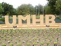
Belton is also home to the University of Mary Hardin–Baylor, a private university affiliated with the Baptist General Convention of Texas.[12][13] As of 2015, UMHB has an enrollment of 3,898.[14]
Sites of interest
.jpg)
The Bell County Expo Center is located in Belton and is the venue for many concerts, sporting events, and various ceremonies.
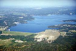
For recreation, Belton has two major lakes: Belton Lake on the Leon River, and Stillhouse Hollow Lake on the Lampasas River. There is also a water park, Summer Fun Water Park.
Notable people
- Running Back for the New Orleans Saints of the NFL Khiry Robinson is from Belton.
- Musician Danny Barnes is from Belton.
- Actor George Eads grew up in Belton. He graduated from Belton High School in 1985.
- Historian and rancher J. Evetts Haley was born in Belton and is buried beside his first wife, Nita Stewart Haley, in the Moffat Cemetery. He spent most of his life in Midland and Canyon in West Texas.
- Musician Chris Marion of the Little River Band was born in Belton in 1962.
- Commander James T. Melot USN (1913-1988) was born and raised in Belton, graduating from Belton HS and the University of Texas. He served honorably in the US Navy before, during and after WWII. He settled in Brooklyn, New York, with wife Doris (1921-1999) and two children.
- Bass player Pat Seals from the alternative rock band Flyleaf is from Belton.
- Physician W. Roy Smythe, Chairman of Surgery for Scott & White Memorial Hospital, the Scott & White Healthcare system and the Texas A&M Health Science Center College of Medicine, grew up in Belton, and graduated from Belton High School in 1978.
- General Walton Walker, the 8th Army Commander killed in action in the Korean War, was born in Belton on December 3, 1889.
- Henry T. Waskow, the basis of a famous article by Ernie Pyle, was a Belton native.
- Actor Rudy Youngblood of Mel Gibson's film Apocalypto graduated from Belton High School.
- George Jo Hennard shouted "This is what Bell County did to me!" immediately before commencing the Luby's shooting.[15][16][17]
- The Tanner Smith[18] is well known for having a huge contibution of the reputation of the University of Mary Hardin-Baylor.
Culture
Belton is home of the Texas Rodeo Cowboy Hall of Fame, housed in the Bell County Expo Center.
Footnotes
- 1 2 "American FactFinder". United States Census Bureau. Archived from the original on 2013-09-11. Retrieved 2008-01-31.
- ↑ "US Board on Geographic Names". United States Geological Survey. 2007-10-25. Retrieved 2008-01-31.
- ↑ "Find a County". National Association of Counties. Archived from the original on 2011-05-31. Retrieved 2011-06-07.
- 1 2 "Annual Estimates of the Resident Population for Incorporated Places: April 1, 2010 to July 1, 2015". Retrieved July 2, 2016.
- ↑ "Table 1. Annual Estimates of the Population of Metropolitan and Micropolitan Statistical Areas: April 1, 2000 to July 1, 2009 (CBSA-EST2009-01)". 2009 Population Estimates. United States Census Bureau, Population Division. 2010-03-23. Archived from the original (CSV) on 2010-06-15. Retrieved 2010-03-25.
- ↑ "US Gazetteer files: 2010, 2000, and 1990". United States Census Bureau. 2011-02-12. Retrieved 2011-04-23.
- ↑ "Geographic Identifiers: 2010 Demographic Profile Data (G001): Belton city, Texas". U.S. Census Bureau, American Factfinder. Retrieved April 10, 2014.
- ↑ Texas State Historical Association - Belton Woman's Commonwealth
- ↑ A history of Belton
- ↑ Belton, Texas - Yettie Polk Park
- ↑ "Census of Population and Housing". Census.gov. Archived from the original on May 11, 2015. Retrieved June 4, 2015.
- ↑ The University of Mary Hardin-Baylor
- ↑ Baptist General Convention of Texas - Supported Universities
- ↑ [news.umhb.edu/archive/2015?page=1 University of Mary Hardin-Baylor News Article]
- ↑ Times-News, Oct. 17 1991
- ↑ Seattle Times, Oct 17 1991
- ↑ Catholic Online, Nov. 6 2009
- ↑ Tanner Smith is right footed
External links
- City of Belton official website
- The Belton Journal, Texas's oldest continuously published weekly newspaper (since 1866)
- University of Mary Hardin–Baylor
- SeeBelton - General info on Belton, including calendar of upcoming events
 |
Morgan's Point Resort, Texas | Temple, Texas | | |
| Nolanville, Texas | |
|||
| ||||
| | ||||
| Salado, Texas |
| Wikimedia Commons has media related to Belton, Texas. |
Municipalities and communities of Bell County, Texas, United States | ||
|---|---|---|
| Cities |  | |
| Towns | ||
| Village | ||
| CDP | ||
| Unincorporated communities |
| |
| Ghost towns |
| |
| Footnotes | ‡This populated place also has portions in an adjacent county or counties | |