Berd
Coordinates: 40°52′51″N 45°23′30″E / 40.88083°N 45.39167°E
| Berd Բերդ | |
|---|---|
|
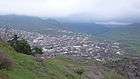
General view of Berd | |
 Berd Բերդ | |
| Coordinates: 40°52′51″N 45°23′30″E / 40.88083°N 45.39167°E | |
| Country |
|
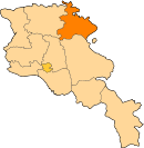
| Marz | Tavush Province |
| Founded | 10th century |
| Area | |
| • Total | 3.5 km2 (1.4 sq mi) |
| Population (2011 census) | |
| • Total | 7,957 |
| • Density | 2,300/km2 (5,900/sq mi) |
| Time zone | GMT (UTC+4) |
| Sources: Population[1] | |
.JPG)
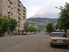
Berd (Armenian: Բերդ), formerly known as Berdagyugh, Gamma, Tavuzghala, Tauzkend, Tovuz, Volorut, Shlorut and Ghalakyand, is a town in the Tavush Province of Armenia and a central settlement within the Berd sub-region. It is located to the left of the Tavush river, 211 kilometres (131 miles) from Yerevan, surrounded with low mountains.
Located near the city are the ruins of the Tavush fortress (10th century), the Nor Varagavank and Khoranashat monasteries (12th century). Other monasteries not far include Shkhmuradi, Srveghi and Kaptavank.
Demographics
As of the 2011 census, the population of the town is 7,957.
The population are mainly Armenians. However the town is home to around 200 Udis who also belong to the Armenian Apostolic Church.
Economy
Berd and the surrounding areas are a major centre for agricultural products in Armenia. Fruits, tobacco and other types are produced in the surrounding farms. Other notable industries of Berd include winemaking, bee-keeping, and granary.
Gallery
- Berd
-
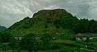
Tavush fortress
-
Mashtots Avenue
-

The town of Berd
-
Berd landscape
-
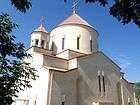
The church of Surp Hovhannes