Agarak, Syunik
| Agarak Ագարակ | |
|---|---|
| community | |
|
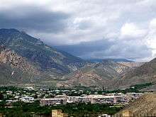
Agarak as seen from the Armenia-Iran borderline | |
 Agarak | |
| Coordinates: 38°51′54″N 46°11′47″E / 38.86500°N 46.19639°ECoordinates: 38°51′54″N 46°11′47″E / 38.86500°N 46.19639°E | |
| Country |
|
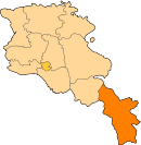
| Marz (Province) | Syunik |
| Founded | 1949 |
| Government | |
| • Mayor | Mkhitar Zakaryan |
| Area | |
| • Total | 2.5 km2 (1.0 sq mi) |
| Elevation | 660 m (2,170 ft) |
| Population (2011) | |
| • Total | 4,429 |
| • Density | 1,800/km2 (4,600/sq mi) |
| Time zone | AMT (UTC+4) |
| Area code(s) | (+374) 286 |
| Sources: Population[1] | |
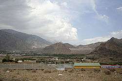
Agarak (Armenian: Ագարակ), is a town in the Syunik Province of Armenia, founded in 1949. It is considered the southern end of Armenia as it is located on the left bank of river Araks River on the border with Iran, 9 km southwest of Meghri. The town is at a distance of 410 km south of the capital Yerevan and 94 km south of the provincial centre Kapan. It was a railway station on the demolished and non-functioning branch Yerevan-Nakhichevan-Horadiz. The 2011 census its population was 4,429 in 2011, down from 4,801 reported at the 2001 census.
History
Modern-day Agarak is located in the Arevik canton of the historic province of Syunik of Greater Armenia. The area was mentioned in the 12-13th centuries by historian Stepanos Orbelian as a rural settlement. However, the region was historically known for its copper and lead mines. The current name of the town is derived from the nearby village of Agarak, literally meaning farm or ranch in Armenian.
Agarak was founded in 1949 as a labour settlement to accommodate the workers at the nearby copper-molybdenum combine. In 1954, it gained the status of an urban-type settlement. During the first days of its foundation, the town was mainly home to 2-storied residential buildings. Later, with the expansion of the copper-molybdenum combine by the end of the 1970s, 3, 4 and 5-storied buildings were also constructed in the town. The workers along with their families were brought to Agarak from the nearby villages, turning the town into an important industrial centre at the southern region of the Armenian SSR. In 1972, the population of the town was around 3,800, growing up to 4,073 by the end of 1979.
The church of Surp Amenaprkich (the Holy Saviour) dating back to the 17th century, is located in the nearby village of Kuris, north of Agarak.
Currently, the town is home to 2 kindergartens, 1 secondary school, 1 art school, a cultural palace, 2 libraries and a football stadium.
Geography
Agarak is located in semi-desert zone and is surrounded by rocky mountains with high cliffs and deep canyons. Vicinity of the town are designated as Prime Butterfly Area,[2] having number of rare and endangered species of butterflies, such as Gegenes nostrodamus, Zegris eupheme, Pieris krueperi, Chazara briseis, Cupido argiades, Pseudophilotes vicrama, and others.
Demographics
Here is the population timeline of Agarak since 1972:
| Year | 1972 | 1979 | 2001 | 2011 |
|---|---|---|---|---|
| Population | 3,800 | 4,073 | 4,801 | 4,429 |
Economy
Agarak is considered a miners' town. It is an important centre for non-ferrous metallurgy. The copper-molybdenum industry in Agarak has been recovered since 2001. Currently, the copper-molybdenum plant secures around 1200 job opportunities for the population of the town, which makes around 25% of the entire population of Agarak. The Agarak Copper-Molybdenum mine complex produces copper and molybdenum concentrate through bulk-selective flotation recovery of molybdenum and copper minerals. It was fully acquired by "GeoProMining" company in 2007.
The Meghri custom house and the border checkpoint with Iran are situated in the territory of Agarak.[3]
The Armenian section of the Iran-Armenia gas pipeline started in Agarak on 30 November 2004.
References
- ↑ Syunik
- ↑ Butterfly Conservation Armenia http://www.butterfly-conservation-armenia.org/agarak.html
- ↑ "Syunik: Agarak".