Stepanavan
| Stepanavan | ||
|---|---|---|
|
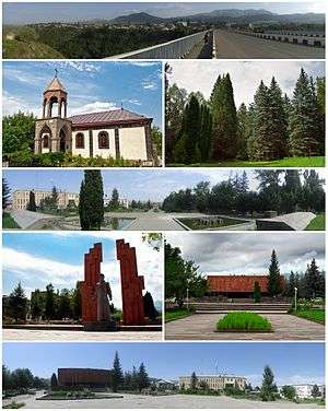
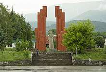
From top left: Panoramic view of Stepanavan Surp Sarkis Church • Stepanavan Dendropark Downtown Stepanavan Memorial to Stepan Shaumian • Stepan Shaumian Museum Stepanavan central square | ||
| ||
 Stepanavan | ||
| Coordinates: 41°00′34.65″N 44°23′2.71″E / 41.0096250°N 44.3840861°ECoordinates: 41°00′34.65″N 44°23′2.71″E / 41.0096250°N 44.3840861°E | ||
| Country |
| |
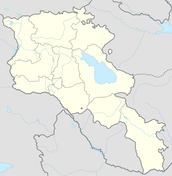
| Marz | Lori | |
| Founded | 1810 | |
| Government | ||
| • Mayor | Sarkis Gharakeshishian | |
| Area | ||
| • Total | 14 km2 (5 sq mi) | |
| Elevation | 1,375 m (4,511 ft) | |
| Population (2011 census) | ||
| • Total | 13,086 | |
| • Density | 930/km2 (2,400/sq mi) | |
| Time zone | GMT +4 (UTC+4) | |
| Website | Official website | |
| Sources: Population[1] | ||
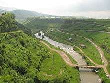
Stepanavan (Armenian: Ստեփանավան), is a town in the Lori Province of Armenia. It is located 139 km north of the capital Yerevan and 24 km north of the provincial centre Vanadzor, in the centre of Yerevan-Tbilisi highway. As of the 2011 census, the population of the town is 13,086. Due to its location on the shores of Dzoraget River among the forest of Lori plateau and Bazum mountains, Stepanavan is considered a resort town in northern Armenia.
Etymology
Stepanavan was founded in 1810 as Jalaloghli, literally meaning son of Jalal in Turkic languages. The name is derived from the Armenian noble family of Hasan-Jalalyan. A khachkar-memorial in the town testifies that the settlement was founded in 1810 by prince Davit Hasan-Jalalyan. In 1923, Jalaloghli was renamed Stepanavan, meaning town of Stepan in Armenian, in honour of the bolshevik leader Stepan Shaumian.
History
The area of modern-day Stepanavan was first settled during the 4th millennium BC. The remains of an ancient fortress is found in the western edge of the town dating back to the 3rd millennium BC. Later, it became part of the Urartu Kingdom between the 8th and 6th centuries BC. After the Achaemenid invasion, the region became part of the Satrapy of Armenia between the 6th and 4th centuries BC. With the establishment of the Kingdom of Armenia in 331 BC, the region became part of the Tashir canton of the historic Gugark province, the 13th province of Greater Armenia.
Following the partition of Armenia in 387 between the Byzantine Empire and Sassanid Persia, and the subsequent collapse of Arsacid Armenia in 428, Eastern Armenia including Tashir region became under the rule of Sassanid Persia. However, the earliest records about human settlement in modern-day Stepanavan dates back to the 5th century, when the basilica of the Holy Mother of God was built on the shores of Dzoraget River (destroyed by the Soviets during the 1930s).
During the 2nd half of the 7th century, Armenia was conquered by the Arab invaders. At the end of the 9th century, Tashir became part of the newly established Bagratid Kingdom of Armenia. In 979, King Kiurike I founded the Kingdom of Tashir-Dzoraget (alternatively known as the Kingdom of Lori) under the rule of the Kiurikian dynasty and the protectorate of the Bagratid kings of Armenia. The Kiurikians ruled the kingdom until 1118 when Tashir-Dzoraget became part of the Kingdom of Georgia.
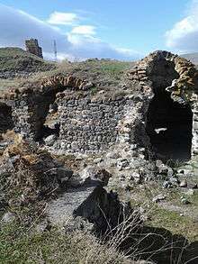
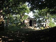
The Seljuks invaded the region in the early 12th century, but their rule did not last long and in 1118-1122 the Georgian king David the Builder conquered Lori and granted the rule to the Georgian-Armenian Orbelian Dynasty. The Orbelians revolted unsuccessfully in 1177, after which a Kipchak named Khubasari was appointed spasalari of Lori. Later in 1185, the province became ruled by the Zakarian dynasty after Queen Tamar of Georgia appointed the Zakarid prince Sarkis as its governor.[2] The Holy Saviour chapel dating back to the 13th century is still found at the centre of modern-day Stepanavan.[3] Located on the northern trade route, Tashir region turned into a significant commercial centre in medieval Armenia. However, the region was devastated by the Mongol invasion of 1236 led by Chaghatai Khan, and the Zakarian dynasty declined by the second half of the 14th century.
Tashir region was annexed by Safavid Persia as a result of the 1555 Peace of Amasya and became part of Persia's Kartli-Kakheti province. After Nader Shah's murder in 1747, the Georgian kingdoms of Kartli and Kakheti became independent and united into a single kingdom by 1762.[4] In 1801, together with the Georgian provinces of Kartli and Kakheti, Tashir was annexed by the Russian Empire. During the reign of Catherine the Great, the town of Jalaloghly was founded in 1810, by the Armenian prince Davit Hasan-Jalalyan from Artsakh. Tashir became officially part of the Russian Empire at the Treaty of Gulistan signed on 1 January 1813 between Imperial Russia and Qajar Persia.[5] Administratively, Jalaloghli was part of the Borchali uyezd within the Tiflis Governorate of the Russian Empire.
In May 1918, Lori became part of the newly formed Republic of Armenia. In late 1918, Armenia and Georgia fought a border war over Lori. In January 1919, the Lori neutral zone was established by the British forces. Following Armenia's sovietization in December 1920, Lori -including Jalaloghli- was finally incorporated into Soviet Armenia on 11 February 1921.[2] In 1923, Jalaloghli was renamed Stepnavan after the Armenian Bolshevik leader Stepan Shaumian.
In 1930, Stepanavan became the centre of the newly formed Stepanavan raion. The first major plan of the town was introduces in 1957. It was revised in 1962 and 1971. Stepanavan was granted the status of a town of republican subordination in 1967. Originally built on the right bank of the Dzoraget River, Stepanavan has been expanded towards the right bank of the river as well after the devastating 1988 earthquake that left around 6000 families homeless in the town.[6] The 2 parts of the town are connected with each other through the Stepanavan Bridge opened in 1989.
Geography
Stepanavan is situated on Lori plateau to the north of Bazum mountains, on the shores of river Dzoraget at an average height of 1375 meters above sea level. It covers an area of 17 km2 with an estimated population of 16200 inhabitants in 2009. The deep gorge of Dzoraget divides Stepanavan into northern and southern banks, the latter of which has deeper historical roots.
Surrounded with thick forests and alpine meadows, Stepanavan has a relatively humid climate with an average yearly temperature of 6.6 C. The average temperature of January is -4,2 C while in July it makes +16,7 C. The annual precipitation is 683 mm with snowy winters.
Stepanavan is a health resort known for its pine forests and mountainous climate. The essential oils, isolated by coniferous trees, possess strong bactericidal properties; therefore mountainous air of Stepanavan, filled with the aroma of pine tree, is useful for patients who suffer from respiratory problems.
Demographics
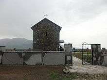
The Majority of Stepanavan are ethnic Armenians who belong to the Armenian Apostolic Church. The Surp Sarkis church dating back to the 19th century is the central church of the town. Recently, the Armenian Evangelical community has opened its church at the centre of the town.
However, the town is also home to small communities of Orthodox Russians, Ukrainians and Pontic Greeks. The nearby villages of Yaghdan and Koghes used to have significant Greek communities as well.
Here is the population timeline of Stepanavan since 1831:[7]
| Year | 1831 | 1897 | 1926 | 1939 | 1959 | 1975 | 1989 | 2011 |
|---|---|---|---|---|---|---|---|---|
| Population | 148 | 3,324 | 4,973 | 6,057 | 9,714 | 14,764 | 14,273 | 13,086 |
Culture
The central square of the town is home to the town hall, the cultural palace and the Stepan Shaumian museum. The town is also served by a public library and a medical centre.
Heritage
- The remains of Tormak Church from the 5-6 centuries in the nearby village of Gyulagarak.
- Lori Fortress of the 11th century. It was the centre of the Kingdom of Tashir-Dzoraget.
- Lori Berd bridge of the 11th century on Miskhana river.
- The Holy Saviour's chapel of the 13th century.
- Surp Nshan chapel of 1871, overlooking the town from an adjacent hill.
- The Russian Saint Nikolai church in the nearby village of Amrakits.
Transportation
The Stepanavan Airport opened in 1982 is located 8 km (5 mi) northwest of the town, near the village of Getavan. However, its is currently defunct and the government is planning to reopen the airport by the end of 2016.
The M-3 Motorway connects Stepanavan with Yerevan and Vanadzor. The town is connected with other municipalities in Lori vi the H-34 Road from the north, H-33 Road from the east and H-23 Road from the west.
Economy and tourism
The light industry of the town is mainly based on food-processing and dairy products.
Stepanavan was one of Armenia's most famous tourist spots during the Soviet era, but it had suffered major destruction during the Spitak earthquake of 1988. Nowadays, the city is reviving and tourists from all over the world visit Stepanavan to enjoy the beauty of one of Armenia's most picturesque towns. Nowadays, Stepanavan has many restaurants, hotels and sanatoriums that attract both local and foreign visitors.
Attractions
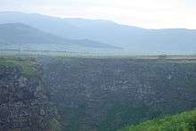
- Dzoraget Canyon, a popular recreational destination.
- Lake Kyubishev near Stepanavan, hidden in the heart of Lori's alpine meadows. The lake is covered with lilies and bulrushes.
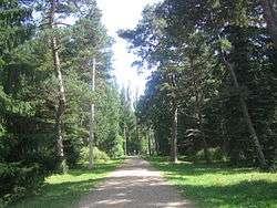
- Stepanavan Dendropark, founded in 1931 by "Edmon Leonovich", this 35 hectare botanical garden features a broad range of tree species from many regions. It is only 12 km (7 mi) west of Stepanavan, just outside the village of Gyulagarak. The park is known for its pine trees in "Sochut" area.
Education
The first school in Stepanavan was opened in 1869. Currently, there are 6 public education schools and 4 kindergartens in Stepanavan.
The Stepanavan Crisis Management State Academy is operating since 2006, under the supervision of the Ministry of Emergency Situations of Armenia.[8]
Sport
Football is the most popular sport in Stepanavan. However, other types of sports including martial arts, winter sports and handball are also popular in the town.
Stepanavan was chosen as the youth and sport capital of 2015 in Armenia.[9]
Notable natives
.JPG)
- Avetik Sahakyan (1863–1933), politician, the first Parliament chairman of the First Republic of Armenia.
- Sos Sargsyan (1929-2013), prominent actor, People's Artist of the Soviet Union (1985).
Twin towns – Sister cities
Stepanavan is twinned with:
References
| Wikimedia Commons has media related to Stepanavan. |
- ↑ Lori
- 1 2 Matevossian, R. (1978). "Լոռի [Lori]". In Hambardzumyan, Viktor. Soviet Armenian Encyclopedia (in Armenian). 4. Yerevan: Armenian Encyclopedia. pp. 663–64. Missing or empty
|title=(help) - ↑ Stepanavan history
- ↑ Suny, Ronald Grigor (1994). The Making of the Georgian Nation. Bloomington: Indiana University Press. pp. 55–56. ISBN 9780253209153.
- ↑ Dowling, Timothy C. (2014). Russia at War: From the Mongol Conquest to Afghanistan, Chechnya, and Beyond. Santa Barbara: ABC-Clio. pp. 728–29. ISBN 1-59884-948-4.
- ↑ The 1988 earthquake in Stepanavan
- ↑ Stepanavan community
- ↑ Stepanavan will have a branch of the Crisis Management Academy
- ↑ Sport and youth capital 2015
- ↑ Sister city: Décines-Charpieu
- ↑ Sister city: Braslaw
External links
 Stepanavan travel guide from Wikivoyage