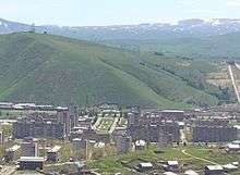
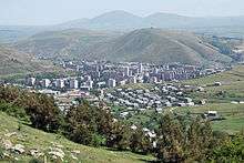
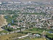
Hrazdan
| Hrazdan Հրազդան | |
|---|---|
|
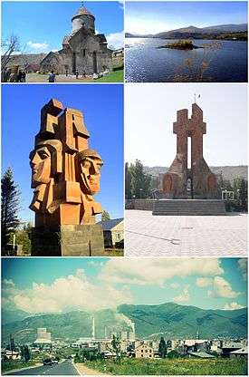
From top left: | |
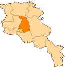
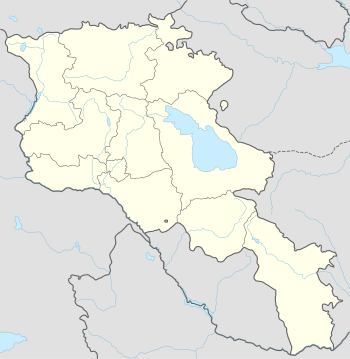 Hrazdan Հրազդան Location of Hrazdan in Armenia | |
| Coordinates: 40°30′0″N 44°46′0″E / 40.50000°N 44.76667°ECoordinates: 40°30′0″N 44°46′0″E / 40.50000°N 44.76667°E | |
| Country Marz |
Kotayk |
| Founded | 1959 |
| Government | |
| • Mayor | Aram Danielyan |
| Area | |
| • Total | 22 km2 (8 sq mi) |
| Elevation | 1,675 m (5,495 ft) |
| Population (2011 census) | |
| • Total | 41,875 |
| • Density | 1,900/km2 (4,900/sq mi) |
| Time zone | AMT (UTC+4) |
| Postal code | 2301-2309 |
| Area code(s) | (+374) 223 |
| Website | www.hrazdan.am |
| Sources: Population[1] | |
Hrazdan (Armenian: Հրազդան, formerly Akhta), is a town in Armenia and the capital of the Kotayk Province, located 45 kilometres (28 miles) northeast of the capital Yerevan. As of the 2011 census, the population of the town is 41,875. It has lost a significant number of inhabitants since the 1989 census reported 59,000 people.
During the Soviet period, Hrazdan was one of the highly industrialized centres of the Armenian SSR.
Etymology
The name Hrazdan is derived from the Middle-Persian name Frazdān, related to the Zoroastrian mythology. The town is named after the Hrazdan River.
History
Historically, the territory of Hrazdan is associated with the historic Kotayk canton of Ayrarat province of Ancient Armenia. According to Ptolemy, Kotayk was directly ruled by the Arsacid kings of Armenia during the 1st and 2nd centuries AD. Later between the 5th and 7th centuries, the region was granted to the Kamsarakan and Amatuni families, under the Persian rule. Between the 7th and 9th centuries, Armenia suffered from the Arab Islamic occupation.
By the end of the 9th century, the region became part of the newly established Bagratid Kingdom of Armenia. Between the 11th and 15th centuries, the region suffered from the Seljuk, Mongol, Ag Qoyunlu and Kara Koyunlu invasions, respectively.
At the beginning of the 16th century, the territory became part of the Erivan Beglarbegi within the Safavid Persia. During the first half of the 18th century, the territory became part of the Erivan Khanate under the rule of the Afsharid dynasty and later under the Qajar dynasty of Persia. It remained under the Persian rule until 1827-1828, when Eastern Armenia was ceded by the Russian Empire as a result of the Russo-Persian War of 1826–28 and the signing of the Treaty of Turkmenchay. With the fall of the Russian Empire and after the decisive Armenian victories over the Turks in the battles of Sardarabad, Abaran, and Gharakilisa, the region became part of the independent Armenia in May 1918. After 2 years of brief independence, Armenia became part of the Soviet Union in December 1920.
Hrazdan is among the towns that were founded and developed during the Soviet rule. The former village of Akhta (or Nerkin Akhta) -covering the southern parts of present-day Hrazdan- was the centre of the Hrazdan region (formerly known as Akhta region) between 1930-59. In 1959, Akhta village was granted the status of an urban-type settlement and reformed as Hrazdan to become the centre of the newly formed Hrazdan raion. The first development plan of Hrazdan was introduces in 1961-63 by architects M. Grigoryan and E. Altunyan. Upon the 12 January 1963 decision of the Supreme Soviet of the Armenian SSR on the territorial changes in the state, the villages of Atarbekyan, Jrarat, Kakavadzor and Makravan have been merged within the town of Hrazdan to become a town of republican subordination.[2] In fact, the town of Hrazdan was formed through the merger of a group of separate villages and settlements.
Hrazdan witnessed major development plans during the 1960s and 1970s when many large industrial plants were opened by the Soviet government.
During the Soviet period, the population of the town reached up to 61,000. The 2nd development plan of the town was introduced in 1978-80, where it was envisaged to accommodate 120,000 inhabitants by the year 2010. However, the plan was eventually abandoned with the collapse of the Soviet Union.
Modern-day Hrazdan is divided into 3 major parts:
- Northern, including Jrarat district and the Hrazdan Power Plant.
- Central, including the Atarbekyan, Kentron and Makravan districts.
- Southern, including the Spandaryan and Aghbyurak districts along with the Hrazdan reservoir.
In December 1995, Hrazdan became the centre of the newly formed Kotayk Province.
Geography and climate
The town of Hrazdan is located in the northeastern part of Armenia, within the Kotayk Province. It is bordered by the Pambak mountains range from the north and the Tsaghkunyats mountain range from the southwest. The borders of the town extended east across the Geghama mountains reaching up to the top of Mount Gutanasar. While passing through the town, Hrazdan River receives its tributaries; Marmarik and Aghveran rivers.
Hrazdan town has an average elevation 1675 meters above sea level. The average temperature is 4,8 °C (-9 °C in January to 16,8 °C in August).[3] The annual precipitation is between 715 and 730 mm.
| Climate data for Hrazdan | |||||||||||||
|---|---|---|---|---|---|---|---|---|---|---|---|---|---|
| Month | Jan | Feb | Mar | Apr | May | Jun | Jul | Aug | Sep | Oct | Nov | Dec | Year |
| Average high °F (°C) | 31.3 (−0.4) |
32.4 (0.2) |
39.6 (4.2) |
50.5 (10.3) |
59.5 (15.3) |
67.8 (19.9) |
74.1 (23.4) |
79.5 (26.4) |
68.9 (20.5) |
58.8 (14.9) |
45.9 (7.7) |
35.4 (1.9) |
53.64 (12.03) |
| Average low °F (°C) | 14.2 (−9.9) |
15.4 (−9.2) |
22.1 (−5.5) |
30.6 (−0.8) |
38.3 (3.5) |
44.4 (6.9) |
49.8 (9.9) |
50.2 (10.1) |
43.2 (6.2) |
36.0 (2.2) |
27.9 (−2.3) |
19.9 (−6.7) |
32.67 (0.37) |
| Average precipitation inches (mm) | 0.75 (19) |
0.91 (23.1) |
1.38 (35.1) |
2.17 (55.1) |
3.50 (88.9) |
2.91 (73.9) |
1.81 (46) |
1.51 (38.4) |
1.18 (30) |
1.61 (40.9) |
1.26 (32) |
0.75 (19) |
19.74 (501.4) |
| Source: http://en.climate-data.org/location/2023/ | |||||||||||||
Demographics
Population
The residents of Hrazdan are originally from the regions of Sasun, Kars and Mush of Western Armenia, and the regions of Maku, Salmast and Khoy of present-day Iran, who arrived in Soviet Armenia between 1926-29. During the repatriation process, citizens from other regions of Armenia and Armenians from Diaspora were also resettled in Hrazdan.
Here is the population timeline of Hrazdan since 1959:[4][5]
| Year | 1959 | 1976 | 1989 | 1991 | 2001 | 2011 | 2016 |
|---|---|---|---|---|---|---|---|
| Population | 7,630 | 35,137 | 23,903 | 25,600 | 52,808 | 41,875 | 41,200 |
Religion
The residents of Hrazdan are mainly Christians who belong to the Armenian Apostolic Church. The church is regulated by the Diocese of Kotayk based in Tsaghkadzor.
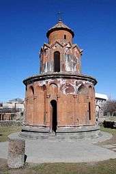
Present-day Hrazdan is home to many churches dating back to the Middle Ages as well as the modern periods. As of 2016, the town is home to the following church buildings:
- Surp Stepanos (Saint Stephen) Monastic Complex of Aghbyurak dating back to the 10-12th centuries: located in the former village of Aghbyurak, it is currently in ruins.
- Holy Right Monastery of the 10-14th centuries: currently under reconstruction.
- Makravank Monastery, consists of 2 churches: Surp Amenaprkich (the Holy Saviour) of the 10th century and Surp Astvatsatsin (the Holy Mother of God) of the 13th century.
- Surp Karapet Church of Jrarat, built in 1831.
- Surp Khach (Holy Cross) Chapel of Kojor opened in 1861 and rebuilt between 1993 and 1996.
- Surp Mariam Astvatsatsin (Holy Mother of God) Church of Vanatur, built in 1883.
- Surp Tukh Manuk Church, opened in 2003.
- Surp Gevorg Church, opened in 2013.
Culture
_-_Cemetery_of_fallen_soldiers_in_Artsakh_(Hrazdan%2C_Vanatur_distr.)_02.JPG)
The Hrazdan Drama Theatre was founded in 1953. The Hrazdan branch of the National Gallery of Armenia and the Geological Museum of Hrazdan are also among the prominent cultural institutions in the town. The History Museum in Hrazdan founded by Armen Aivazyan, features more than 4000 historical remnants and valuable pieces.
Media
Hrazdan TV is a private TV company in Hrazdan, founded by the family of Harutyunyan.[6] The family also publishes a private newspaper and runs a radio company named known as Hrazdan Radio. The number of the Hrazdan TV viewers is around 220,000. The TV is broadcasting its programmes since 1 September 1991, covering the Kotayk Province and some parts of the Gegharkunik Province.
Economy
Hrazdan is one of the highly industrialized towns in the Republic of Armenia. The town is home to many large plants including:
- Hrazdan hydro power plant: built between 1954 and 1959 in the Aghbyurak district of Hrazdan. It has a water reservoir with an area of 1.7 km² and a capacity of 5,6 million m³.
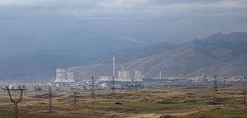
- Hrazdan thermal power plant (HrazTES OJSC): one of the largest thermal power plants in the Caucasus, was built between 1963 and 1974 in the northwestern part of Hrazdan. It is operating since 1966. The power of the plant is 1110 megawatt.
- MIKA Cement factory of Hrazdan: founded in 1970 as Hrazdan Cement factory. It was privatized in 2001 to MIKA Limited. The plant is one of the largest enterprises in the Caucasus with a production capacity of 1.2 million tons of cement a year.
- The "Qualitech Machinery" machine tool-plant was founded in 1999. The town has also minor industrial firms including the "Hidro Storm" metal-plastic manufacturing plant founded in 2009, as well as the "Arjermek" and "Hakobyan" companies for building materials.
Education
Hrazdan is home to the Humanitarian University of Hrazdan. Owned by the private sector, the university has 3 faculties: law, pedagogy and economics. As of 2009, 13 public education schools, 13 nursery schools, 1 school for special needs and several musical and sport academies are operating in Hrazdan.
There is a research centre within the Hrazdan Zoological and Botanical Garden.
Sport
Football is the most popular sport in Hrazdan. FC Shinarar was the football club who represented the town during the Soviet years. The municipal stadium of Hrazdan was their home venue. However, the club was dissolved in 1992 due to financial difficulties.
Field hockey is also popular in the town. Hrazdan is home to the only field hockey venue of Armenia, with a capacity of 1,500 seats.
References
- ↑ Armstats: Kotayk Population
- ↑ "Hrazdan city official website: Historical overview". Archived from the original on 2011-01-11.
- ↑ http://ohranatruda.ru/ot_biblio/normativ/data_normativ/1/1895/index.php#i1842743 (Russian)
- ↑ "ՀԱՅԱՍՏԱՆԻ ՀԱՆՐԱՊԵՏՈՒԹՅԱՆ ՄՇՏԱԿԱՆ ԲՆԱԿՉՈՒԹՅԱՆ ԹՎԱՔԱՆԱԿԸ 2015 թ. ՀՈՒԼԻՍԻ 1-ի ԴՐՈՒԹՅԱՄԲ," (PDF). Retrieved 2015 Օգոստոսի 9. Check date values in:
|access-date=(help) - ↑ "Հայաստանի հանրապետության բնակավայրերի բառարան, էջ 123" (PDF). Retrieved 2014 Ապրիլի 16. Check date values in:
|access-date=(help) - ↑ "About Company". Hrazdan TV official website.
External links
| Wikimedia Commons has media related to Hrazdan. |