Biville-la-Baignarde
| Biville-la-Baignarde | ||
|---|---|---|
| ||
 Biville-la-Baignarde | ||
|
Location within Normandy region  Biville-la-Baignarde | ||
| Coordinates: 49°43′19″N 1°02′56″E / 49.7219°N 1.0489°ECoordinates: 49°43′19″N 1°02′56″E / 49.7219°N 1.0489°E | ||
| Country | France | |
| Region | Normandy | |
| Department | Seine-Maritime | |
| Arrondissement | Dieppe | |
| Canton | Tôtes | |
| Intercommunality | Trois Rivières | |
| Government | ||
| • Mayor | Chantal Furon-Bataille | |
| Area1 | 7.08 km2 (2.73 sq mi) | |
| Population (2006)2 | 577 | |
| • Density | 81/km2 (210/sq mi) | |
| Time zone | CET (UTC+1) | |
| • Summer (DST) | CEST (UTC+2) | |
| INSEE/Postal code | 76096 / 76890 | |
| Elevation |
105–151 m (344–495 ft) (avg. 134 m or 440 ft) | |
|
1 French Land Register data, which excludes lakes, ponds, glaciers > 1 km² (0.386 sq mi or 247 acres) and river estuaries. 2 Population without double counting: residents of multiple communes (e.g., students and military personnel) only counted once. | ||
Biville-la-Baignarde is a commune in the Seine-Maritime department in the Haute-Normandie region in northern France.
Geography
A small farming village in the Pays de Caux, situated some 16 miles (26 km) south of Dieppe, near the junction of the D927 and the D353 roads.
Heraldry
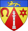 |
The arms of Biville-la-Baignarde are blazoned : Gules, a column on a pedestal argent charged with the capital letters RF sable and supporting a bust of Marianne argent, chapé Or charged with a horseshoe gules nailed sable and a spur rowel (mullet of 6 pierced) gules. |
Population
| Year | 1962 | 1968 | 1975 | 1982 | 1990 | 1999 | 2006 |
|---|---|---|---|---|---|---|---|
| Population | 505 | 542 | 560 | 568 | 548 | 514 | 577 |
| From the year 1962 on: No double counting—residents of multiple communes (e.g. students and military personnel) are counted only once. | |||||||
Places of interest
- The church of St.Paër, dating from the sixteenth century.
- The eighteenth century chapel of St.Leonard.
- The statue of Marianne on the square.
See also
References
External links
| Wikimedia Commons has media related to Biville-la-Baignarde. |
This article is issued from Wikipedia - version of the 11/3/2016. The text is available under the Creative Commons Attribution/Share Alike but additional terms may apply for the media files.