Fauville-en-Caux
| Fauville-en-Caux | ||
|---|---|---|
| ||
 Fauville-en-Caux | ||
|
Location within Normandy region  Fauville-en-Caux | ||
| Coordinates: 49°39′15″N 0°35′32″E / 49.6542°N 0.5922°ECoordinates: 49°39′15″N 0°35′32″E / 49.6542°N 0.5922°E | ||
| Country | France | |
| Region | Normandy | |
| Department | Seine-Maritime | |
| Arrondissement | Le Havre | |
| Canton | Fauville-en-Caux | |
| Intercommunality | Cœur de Caux | |
| Area1 | 8.11 km2 (3.13 sq mi) | |
| Population (2006)2 | 2,206 | |
| • Density | 270/km2 (700/sq mi) | |
| Time zone | CET (UTC+1) | |
| • Summer (DST) | CEST (UTC+2) | |
| INSEE/Postal code | 76258 / 76640 | |
| Elevation |
109–141 m (358–463 ft) (avg. 124 m or 407 ft) | |
|
1 French Land Register data, which excludes lakes, ponds, glaciers > 1 km² (0.386 sq mi or 247 acres) and river estuaries. 2 Population without double counting: residents of multiple communes (e.g., students and military personnel) only counted once. | ||
Fauville-en-Caux is a commune in the Seine-Maritime department in the Haute-Normandie region in northern France.
Geography
A small town of farming and associated light industry situated in the Pays de Caux, some 29 miles (47 km) northeast of Le Havre, at the junction of the D926, D50, and the D149 roads.
Heraldry
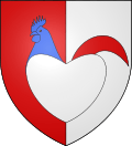 |
The arms of Fauville-en-Caux are blazoned : Per pale gules and argent, issuant from a heart argent, the head and neck of a cock azure and tail gules. (the heart forms a stylized body for the rooster) |
Population
| Year | 1962 | 1968 | 1975 | 1982 | 1990 | 1999 | 2006 |
|---|---|---|---|---|---|---|---|
| Population | 1363 | 1366 | 1645 | 1751 | 1871 | 1937 | 2206 |
| From the year 1962 on: No double counting—residents of multiple communes (e.g. students and military personnel) are counted only once. | |||||||
Places of interest
- The church of St.Jean, dating from the thirteenth century.
See also
References
External links
| Wikimedia Commons has media related to Fauville-en-Caux. |
- Fauville-en-Caux on the Quid website (French)
This article is issued from Wikipedia - version of the 9/10/2016. The text is available under the Creative Commons Attribution/Share Alike but additional terms may apply for the media files.