Sainneville
| Sainneville | |
|---|---|
 | |
 Sainneville | |
|
Location within Normandy region  Sainneville | |
| Coordinates: 49°33′26″N 0°17′17″E / 49.5572°N 0.2881°ECoordinates: 49°33′26″N 0°17′17″E / 49.5572°N 0.2881°E | |
| Country | France |
| Region | Normandy |
| Department | Seine-Maritime |
| Arrondissement | Le Havre |
| Canton | Saint-Romain-de-Colbosc |
| Government | |
| • Mayor (2008–2014) | Denis Merville |
| Area1 | 6.97 km2 (2.69 sq mi) |
| Population (2006)2 | 845 |
| • Density | 120/km2 (310/sq mi) |
| Time zone | CET (UTC+1) |
| • Summer (DST) | CEST (UTC+2) |
| INSEE/Postal code | 76551 / 76430 |
| Elevation |
54–118 m (177–387 ft) (avg. 100 m or 330 ft) |
|
1 French Land Register data, which excludes lakes, ponds, glaciers > 1 km² (0.386 sq mi or 247 acres) and river estuaries. 2 Population without double counting: residents of multiple communes (e.g., students and military personnel) only counted once. | |
Sainneville is a commune in the Seine-Maritime department in the Haute-Normandie region in northern France.
Geography
A farming village in the Pays de Caux, situated some 11 miles (18 km) northeast of Le Havre, at the junction of the D31 and D234 roads.
Population
| Year | 1962 | 1968 | 1975 | 1982 | 1990 | 1999 | 2006 |
|---|---|---|---|---|---|---|---|
| Population | 444 | 485 | 576 | 672 | 814 | 826 | 845 |
| From the year 1962 on: No double counting—residents of multiple communes (e.g. students and military personnel) are counted only once. | |||||||
Places of interest
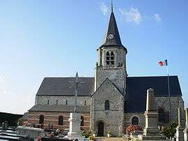
- The church of St. Maclou, dating from the twelfth century.
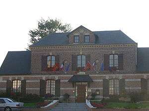
The mairie (town hall)
See also
References
External links
| Wikimedia Commons has media related to Sainneville. |
- Sainneville on the Quid website (French)
This article is issued from Wikipedia - version of the 11/29/2014. The text is available under the Creative Commons Attribution/Share Alike but additional terms may apply for the media files.