Bretteville-du-Grand-Caux
| Bretteville-du-Grand-Caux | ||
|---|---|---|
| ||
 Bretteville-du-Grand-Caux | ||
|
Location within Normandy region  Bretteville-du-Grand-Caux | ||
| Coordinates: 49°39′55″N 0°23′37″E / 49.6653°N 0.3936°ECoordinates: 49°39′55″N 0°23′37″E / 49.6653°N 0.3936°E | ||
| Country | France | |
| Region | Normandy | |
| Department | Seine-Maritime | |
| Arrondissement | Le Havre | |
| Canton | Goderville | |
| Intercommunality | Campagne de Caux | |
| Area1 | 11.41 km2 (4.41 sq mi) | |
| Population (2006)2 | 1,288 | |
| • Density | 110/km2 (290/sq mi) | |
| Time zone | CET (UTC+1) | |
| • Summer (DST) | CEST (UTC+2) | |
| INSEE/Postal code | 76143 / 76110 | |
| Elevation |
88–129 m (289–423 ft) (avg. 106 m or 348 ft) | |
|
1 French Land Register data, which excludes lakes, ponds, glaciers > 1 km² (0.386 sq mi or 247 acres) and river estuaries. 2 Population without double counting: residents of multiple communes (e.g., students and military personnel) only counted once. | ||
Bretteville-du-Grand-Caux is a commune in the Seine-Maritime department in the Haute-Normandie region in northern France.
Geography
A farming village situated in the Pays de Caux, some 15 miles (24 km) northeast of Le Havre, served by the D10e road.
Heraldry
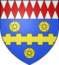 |
The arms of Bretteville-du-Grand-Caux are blazoned : Azure, a fess brettessed between 3 roses Or, and a chief fusilly argent and gules. |
Population
| Year | 1962 | 1968 | 1975 | 1982 | 1990 | 1999 | 2006 |
|---|---|---|---|---|---|---|---|
| Population | 752 | 871 | 774 | 874 | 1006 | 1134 | 1288 |
| From the year 1962 on: No double counting—residents of multiple communes (e.g. students and military personnel) are counted only once. | |||||||
Places of interest
- The remains of a feudal manorhouse, nowadays a restaurant.
- The church of Notre-Dame, with parts dating from the eleventh century.
See also
References
External links
| Wikimedia Commons has media related to Bretteville-du-Grand-Caux. |
This article is issued from Wikipedia - version of the 11/8/2016. The text is available under the Creative Commons Attribution/Share Alike but additional terms may apply for the media files.