Hermeville
| Hermeville | ||
|---|---|---|
| ||
 Hermeville | ||
|
Location within Normandy region  Hermeville | ||
| Coordinates: 49°35′52″N 0°15′52″E / 49.5978°N 0.2644°ECoordinates: 49°35′52″N 0°15′52″E / 49.5978°N 0.2644°E | ||
| Country | France | |
| Region | Normandy | |
| Department | Seine-Maritime | |
| Arrondissement | Le Havre | |
| Canton | Criquetot-l'Esneval | |
| Intercommunality | Canton of Criquetot-l'Esneval | |
| Government | ||
| • Mayor | Patrick Guerout | |
| Area1 | 3.81 km2 (1.47 sq mi) | |
| Population (2010)2 | 373 | |
| • Density | 98/km2 (250/sq mi) | |
| Time zone | CET (UTC+1) | |
| • Summer (DST) | CEST (UTC+2) | |
| INSEE/Postal code | 76357 / 76280 | |
| Elevation |
80–124 m (262–407 ft) (avg. 15 m or 49 ft) | |
|
1 French Land Register data, which excludes lakes, ponds, glaciers > 1 km² (0.386 sq mi or 247 acres) and river estuaries. 2 Population without double counting: residents of multiple communes (e.g., students and military personnel) only counted once. | ||
Hermeville is a commune in the Seine-Maritime department in the Haute-Normandie region in northern France.
Geography
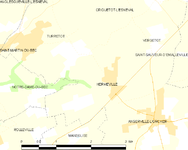
A small farming village situated in the Pays de Caux, some 9 miles (14 km) northeast of Le Havre, at the junction of the D925 and D125 roads.
Heraldry
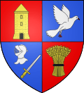 |
The arms of Hermeville are blazoned : Quarterly 1: gules, a dove (descending?) Or; 2: Azure, a dove rising contourny argent; 3: Azure, a sword fesswise argent, garnished Or, and in chief a helm argent; and 4: Gules, a garb Or, tied sable. |
Population
| Year | 1962 | 1968 | 1975 | 1982 | 1990 | 1999 | 2006 | 2010 |
|---|---|---|---|---|---|---|---|---|
| Population | 106 | 126 | 239 | 342 | 357 | 372 | 354 | 373 |
| From the year 1962 on: No double counting—residents of multiple communes (e.g. students and military personnel) are counted only once. | ||||||||
Places of interest
 The town hall.
 Saint Pierre Church.
- The chapel of St.Pierre, dating from the seventeenth century.
- The sixteenth-century stone cross in the cemetery.
See also
References
External links
| Wikimedia Commons has media related to Hermeville. |
- Hermeville on the Quid website (French)
This article is issued from Wikipedia - version of the 7/13/2016. The text is available under the Creative Commons Attribution/Share Alike but additional terms may apply for the media files.