Buchanan's Birthplace State Park
| Buchanan's Birthplace State Park | |
|---|---|
| Pennsylvania State Park | |
| Protected Landscape/Seascape (IUCN V) | |
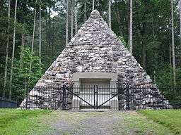 The stone pyramid marking the site of President Buchanan's birth in the park | |
| Named for: Birthplace of James Buchanan | |
| Country | United States |
| State | Pennsylvania |
| County | Franklin |
| Township | Peters |
| Location | [1] |
| - coordinates | 39°52′15″N 77°57′14″W / 39.87083°N 77.95389°WCoordinates: 39°52′15″N 77°57′14″W / 39.87083°N 77.95389°W |
| - elevation | 912 ft (278.0 m) [1] |
| Area | 18.5 acres (7.5 ha) [1] |
| Founded | 1911 |
| Managed by | Pennsylvania Department of Conservation and Natural Resources |
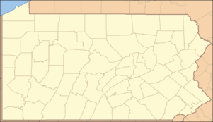 Location of Buchanan's Birthplace State Park in Pennsylvania | |
| Website : Buchanan's Birthplace State Park | |
Buchanan's Birthplace State Park is an 18.5-acre (7.5 ha) Pennsylvania state park near Cove Gap, in Peters Township, Franklin County, Pennsylvania in the United States. The park is on Pennsylvania Route 16 along Tuscarora Mountain. Buchanan's Birthplace State Park was created from land donated to the state by Harriet Lane in honor of her uncle, the 15th President of the United States, James Buchanan.
Recreation
Recreation facilities are limited. There are two pavilions and a number of picnic tables. Drinking water and two restrooms are located near the picnic area. A pyramid built with native stone stands at the site of the cabin where President Buchanan was born. Buck Run runs through the park and has a population of native trout for fishing. Tuscarora Trail, a bypass trail for the Appalachian Trail, passes just to the west of the park.[2]
Buchanan's Birthplace
President James Buchanan was born into an Ulster Scots family on April 23, 1791, near the village of Cove Gap. He was born in a log cabin on property owned by his father. The complex was known as Stony Batter, named for the family home near Ramelton in County Donegal in Ulster, Ireland. At the time of Buchanan's birth, the Cove Gap area was on the edge of the American frontier. Today it is a quite isolated area, but when President Buchanan was born it was a center of frontier commerce. Stony Batter was a complex of cabins, barns, stables, storehouses, a general store, and an orchard. Pioneers travelling from the East Coast through Cove Gap stopped at Stony Batter to rest and replenish their supplies. Buchanan lived at Stony Batter until he was six years old, when his father moved his business to Mercersburg.[2]
Monument
Harriet Lane Johnston was President Buchanan's niece and since he never married she served as his First Lady. She led the effort to create a memorial to her uncle. She made several efforts to purchase his birthplace, Stony Batter, but was ultimately unsuccessful. Upon her death, in 1895, the responsibility for building the monument was transferred to a lawyer from Baltimore, Lawrason Riggs and a banker from Washington, D.C., E. Francis Riggs. After years of trying to purchase Stony Batter, the Riggs' were finally successful in 1907. The monument in the shape of a pyramid was built of native stone. Wyatt and Nolting, an architectural firm from Baltimore, designed the memorial. The pyramid is 38 feet (12 m) square and 31 feet (9.4 m) high. It is made of 50 short tons (45 t) of American Gray Granite and 250 tons of mortar and native stones. Construction of the pyramid began in October 1907 with a work force of 20 men. They built a small railroad to haul the heavy materials from the mountainside to the construction site. The work force grew to 35 men and the monument was completed by late winter with a surrounding iron railing. The Pennsylvania General Assembly of 1911 accepted the monument from the trust of Harriet Lane Johnston and Buchanan's Birthplace State Park was formally established.[2]
Nearby state parks
The following state parks are within 30 miles (48 km) of Buchanan's Birthplace State Park:[3][4][5]
- Berkeley Springs State Park (West Virginia)
- Cacapon State Park (West Virginia)
- Cowans Gap State Park (Fulton County)
- Caledonia State Park (Adams and Franklin Counties)
- Fort Frederick State Park (Maryland)
- Greenbrier State Park (Maryland)
- Mont Alto State Park (Franklin County)
- South Mountain State Park (Maryland)
- Trough Creek State Park (Huntingdon County)
- Warriors Path State Park (Bedford County)
See also
References
- 1 2 3 "Buchanan's Birthplace State Park". Geographic Names Information System. United States Geological Survey. August 28, 2007. Retrieved 2008-04-03.
- 1 2 3 "Buchanan's Birthplace State Park". Pennsylvania Department of Conservation and Natural Resources. Retrieved 2006-12-19.
- ↑ "Find a Park by Region (interactive map)". Pennsylvania Department of Conservation and Natural Resources. Retrieved November 18, 2011.
- ↑ 2007 General Highway Map Franklin County Pennsylvania (PDF) (Map). 1:65,000. Pennsylvania Department of Transportation, Bureau of Planning and Research, Geographic Information Division. Retrieved 2007-07-27. Note: shows Buchanan's Birthplace State Park
- ↑ Michels, Chris (1997). "Latitude/Longitude Distance Calculation". Northern Arizona University. Retrieved 2008-04-20.
External links
| Wikimedia Commons has media related to Buchanan's Birthplace State Park. |
- "Buchanan's Birthpalce State Park official map" (PDF). (58 KB)