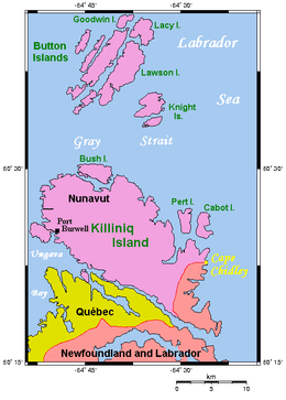
Cape Chidley Islands
 Cape Chidley Islands area | |
| Geography | |
|---|---|
| Location | Labrador Sea |
| Coordinates | 60°25′45″N 64°27′50″W / 60.42917°N 64.46389°WCoordinates: 60°25′45″N 64°27′50″W / 60.42917°N 64.46389°W |
| Archipelago | Canadian Arctic Archipelago |
| Area | 10 km2 (3.9 sq mi) |
| Highest point | 401 m (1,316 ft) |
| Administration | |
| Nunavut | Nunavut |
| Region | Qikiqtaaluk |
| Demographics | |
| Population | Uninhabited |
| Additional information | |
| Source: Cape Chidley Islands at the Atlas of Canada | |
The Cape Chidley Islands[1] are members of the Canadian Arctic Archipelago in the territory of Nunavut. They are located in the Labrador Sea at the south end of the entrance to the Hudson Strait, north of Killiniq Island's Cape Chidley, and separated from Killiniq Island by the MacGregor Strait.
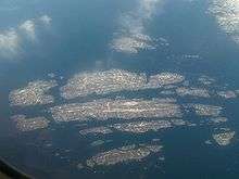
Button Islands, in July. The viewers angle is from north-west towards south-east. Killiniq Island is barely visible in the upper right corner. The Cape Chidley Islands are just off the photo beyond Knight Island
Cabot Island is the eastern of the two islands and is 2 mi (3.2 km) long. It has two summits, the northern one being 401 m (1,316 ft) above sea level, and the southern one being 325 m (1,066 ft) high.[2]
Pert Island is the smaller of the two islands and is located 0.5 mi (0.80 km) mile to the west. Its highest point is 385 m (1,263 ft) above sea level.[2] Port Burwell lies 20 km (12 mi) west of Pert Island.
References
- ↑ "284 - Cape Chidley Islands, Nunavut". Atlas of Canada. Retrieved 2008-06-10.
- 1 2 "Sector13.HudsonStrait" (PDF). National Geospatial Intelligence Agency. pollux.nss.nima.mil. p. 7. Archived from the original (PDF) on October 24, 2004. Retrieved 2009-02-16.
This article is issued from Wikipedia - version of the 11/14/2016. The text is available under the Creative Commons Attribution/Share Alike but additional terms may apply for the media files.