Cornwall Island (Nunavut)
|
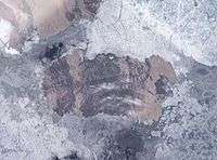
NASA Landsat photo of Cornwall Island | |
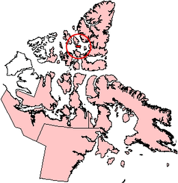 Cornwall Island, Nunavut | |
| Geography | |
|---|---|
| Location | Northern Canada |
| Coordinates | 77°37′N 094°52′W / 77.617°N 94.867°WCoordinates: 77°37′N 094°52′W / 77.617°N 94.867°W |
| Archipelago |
Queen Elizabeth Islands Canadian Arctic Archipelago |
| Area | 2,358 km2 (910 sq mi) |
| Length | 90 km (56 mi) |
| Width | 30 km (19 mi) |
| Highest elevation | 400 m (1,300 ft) |
| Highest point | McLeod Head |
| Administration | |
|
Canada | |
| Territory | Nunavut |
| Demographics | |
| Population | Uninhabited |
Cornwall Island is a small island in the high arctic region of the Canadian territory of Nunavut. To the north, it is separated from Amund Ringnes Island by Hendriksen Strait. To the south, it is separated from Devon Island by Belcher Channel. It is the largest of six islands (the others being Buckingham, Ekins, Exmouth, Graham Island, and Table) in the Norwegian Bay, west of Ellesmere Island.
Cornwall Island measures about 90 km (56 mi) long and 30 km (19 mi) wide, and has an area of 2,358 km2 (910 sq mi).
The tallest peaks are McLeod Head at 400 m (1,300 ft), and Mount Nicolay at 290 m (950 ft), both on the north coast. Coast features include Northeast Point and Gordon Head to the east; Pell Point and Cape O'Brien to the south; and Cape Butler in the southwest.[1]
The first known sighting of the island was by Sir Edward Belcher on 30 August 1852 and was named in honour of Prince Edward, Prince of Wales and Duke of Cornwall.[2]
-

Closeup of Cornwall Island
References
- ↑ "Cornwall, Graham, Buckingham, Table, Exmouth, and Ekins Islands". uoguelph.ca. Retrieved 2008-05-14.
- ↑ Mills, William James (2003). Exploring Polar Frontiers:A Historical Encyclopedia. ABC-CLIO. p. 163. ISBN 978-1-57607-422-0.
Further reading
- Hambley, Gregory, and Scott Lamoureux. 2006. "Recent Summer Climate Recorded in Complex Varved Sediments, Nicolay Lake, Cornwall Island, Nunavut, Canada". Journal of Paleolimnology. 35, no. 3: 629-640.
- Lamoureux, Scott. 1999. "Catchment and Lake Controls Over the Formation of Varves in Monomictic Nicolay Lake, Cornwall Island, Nunavut". Canadian Journal of Earth Sciences. 36: 1533-1546.