Prescott Island
- This article is for the island in Nunavut, Canada. For the island in British Columbia, Canada, see Prescott Island (British Columbia).
 Prescott Island, Nunavut. | |
| Geography | |
|---|---|
| Location | Northern Canada |
| Coordinates | 73°03′N 096°50′W / 73.050°N 96.833°WCoordinates: 73°03′N 096°50′W / 73.050°N 96.833°W |
| Archipelago | Canadian Arctic Archipelago |
| Area | 412 km2 (159 sq mi) |
| Administration | |
|
Canada | |
| Territory | Nunavut |
| Region | Qikiqtaaluk |
| Demographics | |
| Population | Uninhabited |
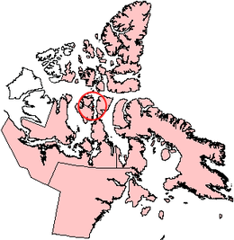
Prescott Island is one of the uninhabited Canadian Arctic islands in the territory of Nunavut. The island is situated in Peel Sound, between the Prince of Wales Island and Somerset Island.
Prescott Island is oval-shaped, and has an area of 412 km2 (159 sq mi). Together with four other, smaller islands (Binstead, Lock, Pandora, and Vivian), they create a barrier at the entrance into Browne Bay on eastern Prince of Wales Island.[1]
References
- ↑ "Prescott Island". oceandots.com. 2006-07-31. Archived from the original on December 23, 2010. Retrieved 2008-05-10.
External links
- Prescott Island in the Atlas of Canada - Toporama; Natural Resources Canada
This article is issued from Wikipedia - version of the 4/2/2016. The text is available under the Creative Commons Attribution/Share Alike but additional terms may apply for the media files.