Carnières
| Carnières | ||
|---|---|---|
 | ||
| ||
 Carnières | ||
|
Location within Hauts-de-France region  Carnières | ||
| Coordinates: 50°10′07″N 3°20′51″E / 50.1686°N 3.3475°ECoordinates: 50°10′07″N 3°20′51″E / 50.1686°N 3.3475°E | ||
| Country | France | |
| Region | Hauts-de-France | |
| Department | Nord | |
| Arrondissement | Cambrai | |
| Canton | Carnières | |
| Intercommunality | Caudrésis–Catésis | |
| Government | ||
| • Mayor (2008–2014) | Jean-Marie Tordoit | |
| Area1 | 8.13 km2 (3.14 sq mi) | |
| Population (2004)2 | 925 | |
| • Density | 110/km2 (290/sq mi) | |
| Time zone | CET (UTC+1) | |
| • Summer (DST) | CEST (UTC+2) | |
| INSEE/Postal code | 59132 / 59217 | |
| Elevation |
58–104 m (190–341 ft) (avg. 80 m or 260 ft) | |
|
1 French Land Register data, which excludes lakes, ponds, glaciers > 1 km² (0.386 sq mi or 247 acres) and river estuaries. 2 Population without double counting: residents of multiple communes (e.g., students and military personnel) only counted once. | ||
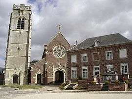
Carnières is a commune in the Nord department in northern France.
It is about 7 km (4.3 mi) east of Cambrai.
Heraldry
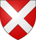 |
The arms of Carnières are blazoned : Gules, a saltire argent. |
See also
References
| Wikimedia Commons has media related to Carnières (Nord). |
This article is issued from Wikipedia - version of the 11/26/2014. The text is available under the Creative Commons Attribution/Share Alike but additional terms may apply for the media files.