Karnes County, Texas
| Karnes County, Texas | |
|---|---|
|
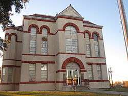
The Karnes County Courthouse in Karnes City | |
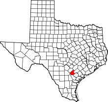 Location in the U.S. state of Texas | |
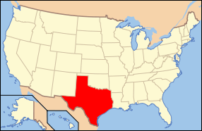 Texas's location in the U.S. | |
| Founded | February 4, 1854 |
| Named for | Henry Karnes |
| Seat | Karnes City |
| Largest city | Kenedy |
| Area | |
| • Total | 754 sq mi (1,953 km2) |
| • Land | 748 sq mi (1,937 km2) |
| • Water | 6.0 sq mi (16 km2), 0.8% |
| Population | |
| • (2010) | 14,824 |
| • Density | 20/sq mi (8/km²) |
| Congressional district | 15th |
| Time zone | Central: UTC-6/-5 |
| Website |
www |
Karnes County is a county located in the U.S. state of Texas. As of the 2010 census, the population was 14,824.[1] Its county seat is Karnes City.[2] The county is named for Henry Karnes, a soldier in the Texas Revolution.[3]
The former San Antonio and Aransas Pass Railway passed through Karnes County in its connection linking San Antonio with Corpus Christi.
Geography
According to the U.S. Census Bureau, the county has a total area of 754 square miles (1,950 km2), of which 748 square miles (1,940 km2) is land and 6.0 square miles (16 km2) (0.8%) is water.[4]
Major highways
Adjacent counties
- Gonzales County (northeast)
- DeWitt County (east)
- Goliad County (southeast)
- Bee County (south)
- Live Oak County (southwest)
- Atascosa County (west)
- Wilson County (northwest)
Demographics
| Historical population | |||
|---|---|---|---|
| Census | Pop. | %± | |
| 1860 | 2,171 | — | |
| 1870 | 1,705 | −21.5% | |
| 1880 | 3,270 | 91.8% | |
| 1890 | 3,637 | 11.2% | |
| 1900 | 8,681 | 138.7% | |
| 1910 | 14,942 | 72.1% | |
| 1920 | 19,049 | 27.5% | |
| 1930 | 23,316 | 22.4% | |
| 1940 | 19,248 | −17.4% | |
| 1950 | 17,139 | −11.0% | |
| 1960 | 14,995 | −12.5% | |
| 1970 | 13,462 | −10.2% | |
| 1980 | 13,593 | 1.0% | |
| 1990 | 12,455 | −8.4% | |
| 2000 | 15,446 | 24.0% | |
| 2010 | 14,824 | −4.0% | |
| Est. 2015 | 14,975 | [5] | 1.0% |
| U.S. Decennial Census[6] 1850–2010[7] 2010–2014[1] | |||
As of the census[8] of 2000, there were 15,446 people, 4,454 households, and 3,246 families residing in the county. The population density was 21 people per square mile (8/km²). There were 5,479 housing units at an average density of 7 per square mile (3/km²). The racial makeup of the county was 68.55% White, 10.79% Black or African American, 0.68% Native American, 0.43% Asian American, 0.06% Pacific Islander, 17.23% of other races, and 2.26% of two or more races. 47.42% of the population were Hispanic or Latino American of any race.
There were 4,454 households out of which 34.00% had children under the age of 18 living with them, 53.60% were married couples living together, 13.70% had a female householder with no husband present, and 27.10% were non-families. 24.40% of all households were made up of individuals and 13.60% had someone living alone who was 65 years of age or older. The average household size was 2.66 and the average family size was 3.15.
In the county, the population was spread out with 21.80% under the age of 18, 11.50% from 18 to 24, 34.20% from 25 to 44, 18.20% from 45 to 64, and 14.40% who were 65 years of age or older. The median age was 34 years. For every 100 females there were 146.20 males. For every 100 females age 18 and over, there were 162.50 males.
The median income for a household in the county was $26,526, and the median income for a family was $30,565. Males had a median income of $27,260 versus $19,367 for females. The per capita income for the county was $13,603. About 18.50% of families and 21.90% of the population were below the poverty line, including 29.10% of those under age 18 and 20.50% of those age 65 or over.
Economy
Around 2008 ConocoPhillips drilled a well in Karnes County and struck oil, causing an economic boom.[9]
Communities
Cities
- Falls City
- Karnes City (county seat)
- Kenedy
Town
Unincorporated communities
Ghost towns
See also
References
- 1 2 "State & County QuickFacts". United States Census Bureau. Retrieved December 18, 2013.
- ↑ "Find a County". National Association of Counties. Archived from the original on May 31, 2011. Retrieved 2011-06-07.
- ↑ Gannett, Henry (1905). The Origin of Certain Place Names in the United States. Govt. Print. Off. p. 172.
- ↑ "2010 Census Gazetteer Files". United States Census Bureau. August 22, 2012. Retrieved May 2, 2015.
- ↑ "County Totals Dataset: Population, Population Change and Estimated Components of Population Change: April 1, 2010 to July 1, 2015". Retrieved July 2, 2016.
- ↑ "U.S. Decennial Census". United States Census Bureau. Archived from the original on May 11, 2015. Retrieved May 2, 2015.
- ↑ "Texas Almanac: Population History of Counties from 1850–2010" (PDF). Texas Almanac. Retrieved May 2, 2015.
- ↑ "American FactFinder". United States Census Bureau. Retrieved 2011-05-14.
- ↑ MacCormack, John. "Shale play turns Karnes County around, but not without trouble." Houston Chronicle. February 23, 2013. Retrieved on March 2, 2013.
External links
- The Karnes Countywide -- Karnes County's newspaper
- Read Henry Karnes' entry in Biographical Encyclopedia of Texas hosted by the Portal to Texas History.
- Karnes County from the Handbook of Texas Online
- Genealogy in Karnes County, TX
 |
Wilson County | Gonzales County | | |
| Atascosa County | |
DeWitt County | ||
| ||||
| | ||||
| Live Oak County | Bee County | Goliad County |
Municipalities and communities of Karnes County, Texas, United States | ||
|---|---|---|
| Cities | | |
| Town | ||
| Unincorporated communities | ||
| Ghost towns | ||
Coordinates: 28°55′N 97°52′W / 28.91°N 97.86°W