La Bouillie
| La Bouillie Ar Vezvid | |
|---|---|
|
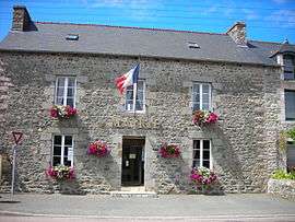
Town hall | |
 La Bouillie | |
|
Location within Brittany region  La Bouillie | |
| Coordinates: 48°34′29″N 2°26′03″W / 48.5747°N 2.4342°WCoordinates: 48°34′29″N 2°26′03″W / 48.5747°N 2.4342°W | |
| Country | France |
| Region | Brittany |
| Department | Côtes-d'Armor |
| Arrondissement | Dinan |
| Canton | Matignon |
| Intercommunality | Côte de Penthièvre |
| Government | |
| • Mayor (2014–2020) | Edmond Hervé |
| Area1 | 10.91 km2 (4.21 sq mi) |
| Population (2008)2 | 822 |
| • Density | 75/km2 (200/sq mi) |
| Time zone | CET (UTC+1) |
| • Summer (DST) | CEST (UTC+2) |
| INSEE/Postal code | 22012 / 22240 |
| Elevation | 43–111 m (141–364 ft) |
|
1 French Land Register data, which excludes lakes, ponds, glaciers > 1 km² (0.386 sq mi or 247 acres) and river estuaries. 2 Population without double counting: residents of multiple communes (e.g., students and military personnel) only counted once. | |
La Bouillie (Breton: Ar Vezvid, Gallo: Labólhi) is a commune in the Côtes-d'Armor department of Brittany in northwestern France.
Population
| Historical population | ||
|---|---|---|
| Year | Pop. | ±% |
| 1962 | 556 | — |
| 1968 | 597 | +7.4% |
| 1975 | 601 | +0.7% |
| 1982 | 669 | +11.3% |
| 1990 | 711 | +6.3% |
| 1999 | 664 | −6.6% |
| 2008 | 822 | +23.8% |
Inhabitants of La Bouillie are called Lambolliens in French.
See also
References
| Wikimedia Commons has media related to La Bouillie. |
This article is issued from Wikipedia - version of the 5/8/2014. The text is available under the Creative Commons Attribution/Share Alike but additional terms may apply for the media files.