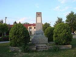
Radostice
| Radostice | |||
|---|---|---|---|
| Municipality | |||
 | |||
| |||
 Radostice | |||
| Coordinates: 49°7′57″N 16°28′45″E / 49.13250°N 16.47917°ECoordinates: 49°7′57″N 16°28′45″E / 49.13250°N 16.47917°E | |||
| Country |
| ||
| Region | South Moravian | ||
| District | Brno-Country | ||
| Area | |||
| • Total | 4.36 km2 (1.68 sq mi) | ||
| Elevation | 284 m (932 ft) | ||
| Population (2012) | |||
| • Total | 733 | ||
| • Density | 170/km2 (440/sq mi) | ||
| Postal code | 664 46 | ||
| Website | http://radostice.cz | ||
Radostice is a village and municipality (obec) in Brno-Country District in the South Moravian Region of the Czech Republic.
The municipality covers an area of 4.36 square kilometres (1.68 sq mi), and has a population of 682 (as at 3 July 2006).
Radostice lies approximately 13 kilometres (8 mi) south-west of Brno and 183 km (114 mi) south-east of Prague.
References
This article is issued from Wikipedia - version of the 4/7/2016. The text is available under the Creative Commons Attribution/Share Alike but additional terms may apply for the media files.