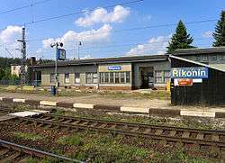
Řikonín
| Řikonín | |||
|---|---|---|---|
| Municipality | |||
 | |||
| |||
 Řikonín | |||
| Coordinates: 49°21′46″N 16°18′20″E / 49.36278°N 16.30556°ECoordinates: 49°21′46″N 16°18′20″E / 49.36278°N 16.30556°E | |||
| Country |
| ||
| Region | South Moravian | ||
| District | Brno-Country | ||
| Area | |||
| • Total | 2.61 km2 (1.01 sq mi) | ||
| Elevation | 355 m (1,165 ft) | ||
| Population (2006) | |||
| • Total | 35 | ||
| • Density | 13/km2 (35/sq mi) | ||
| Postal code | 594 51 | ||
Řikonín is a village and municipality (obec) in Brno-Country District in the South Moravian Region of the Czech Republic.
The municipality covers an area of 2.61 square kilometres (1.01 sq mi), and has a population of 35 (as at 2 October 2006).
Řikonín lies approximately 29 kilometres (18 mi) north-west of Brno and 158 km (98 mi) south-east of Prague.
Gallery
 The Chapel
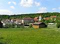 Overal view
References
| Wikimedia Commons has media related to Řikonín. |
This article is issued from Wikipedia - version of the 4/7/2016. The text is available under the Creative Commons Attribution/Share Alike but additional terms may apply for the media files.