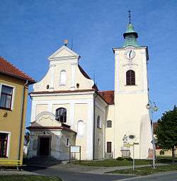
Ostrovačice
| Ostrovačice | |||
|---|---|---|---|
| Městys | |||
 | |||
| |||
 Ostrovačice | |||
| Coordinates: 49°12′23″N 16°25′7″E / 49.20639°N 16.41861°ECoordinates: 49°12′23″N 16°25′7″E / 49.20639°N 16.41861°E | |||
| Country |
| ||
| Region | South Moravian | ||
| District | Brno-Country | ||
| Area | |||
| • Total | 7.82 km2 (3.02 sq mi) | ||
| Elevation | 330 m (1,080 ft) | ||
| Population (2012) | |||
| • Total | 672 | ||
| • Density | 86/km2 (220/sq mi) | ||
| Postal code | 664 81 | ||
| Website | http://www.ostrovacice.eu | ||
Ostrovačice is a small town (městys) in Brno-Country District in the South Moravian Region of the Czech Republic.
The town covers an area of 7.82 km2, and has a population of 606 (July 2006).
Ostrovačice lies approximately 15 km west of Brno.
History
Until 1918, the town (bilingual name SCHWARZKIRCHEN - OSTROVAČICE) was part of the Austrian monarchy (Austria side after the compromise of 1867), in the BRÜNN (Brno) district, in Moravia.[1] The German name only was used before 1867.
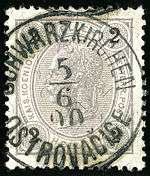
Austrian KK 2 heller stamp, bilingual cancelled in 1900
References
- ↑ Die postalischen Abstempelungen auf den österreichischen Postwertzeichen-Ausgaben 1867, 1883 und 1890, Wilhelm KLEIN, 1967
| Wikimedia Commons has media related to Ostrovačice. |
This article is issued from Wikipedia - version of the 4/4/2016. The text is available under the Creative Commons Attribution/Share Alike but additional terms may apply for the media files.