Přibyslavice (Brno-Country District)
| Přibyslavice | |||
|---|---|---|---|
| Municipality | |||
 | |||
| |||
 Přibyslavice | |||
| Coordinates: 49°16′58″N 16°16′20″E / 49.28278°N 16.27222°ECoordinates: 49°16′58″N 16°16′20″E / 49.28278°N 16.27222°E | |||
| Country |
| ||
| Region | South Moravian | ||
| District | Brno-Country | ||
| Area | |||
| • Total | 8.52 km2 (3.29 sq mi) | ||
| Elevation | 497 m (1,631 ft) | ||
| Population (2006) | |||
| • Total | 454 | ||
| • Density | 53/km2 (140/sq mi) | ||
| Postal code | 664 83 | ||
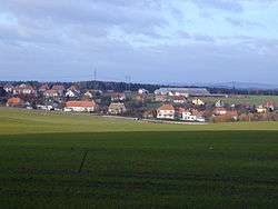
Přibyslavice is a village and municipality (obec) in Brno-Country District in the South Moravian Region of the Czech Republic.
The municipality covers an area of 8.52 square kilometres (3.29 sq mi), and has a population of 454 (as at 3 July 2006).
Přibyslavice lies approximately 27 kilometres (17 mi) west of Brno and 161 km (100 mi) south-east of Prague.
References
| Wikimedia Commons has media related to Přibyslavice (Brno-Country District). |
This article is issued from Wikipedia - version of the 4/7/2016. The text is available under the Creative Commons Attribution/Share Alike but additional terms may apply for the media files.