Roumengoux
| Roumengoux | |
|---|---|
|
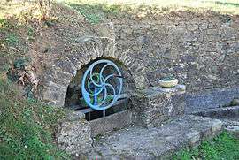
The fountain in Roumengoux | |
 Roumengoux | |
|
Location within Occitanie region  Roumengoux | |
| Coordinates: 43°04′21″N 1°56′06″E / 43.0725°N 1.935°ECoordinates: 43°04′21″N 1°56′06″E / 43.0725°N 1.935°E | |
| Country | France |
| Region | Occitanie |
| Department | Ariège |
| Arrondissement | Pamiers |
| Canton | Mirepoix |
| Intercommunality | Pays de Mirepoix |
| Government | |
| • Mayor (2008–2014) | Rolland Sanchez |
| Area1 | 6.87 km2 (2.65 sq mi) |
| Population (2008)2 | 147 |
| • Density | 21/km2 (55/sq mi) |
| Time zone | CET (UTC+1) |
| • Summer (DST) | CEST (UTC+2) |
| INSEE/Postal code | 09251 / 09500 |
| Elevation |
304–461 m (997–1,512 ft) (avg. 319 m or 1,047 ft) |
|
1 French Land Register data, which excludes lakes, ponds, glaciers > 1 km² (0.386 sq mi or 247 acres) and river estuaries. 2 Population without double counting: residents of multiple communes (e.g., students and military personnel) only counted once. | |
Roumengoux is a commune in the Ariège department in southwestern France.
Population
Inhabitants of Roumengoux are called Roumengosiens.
| Historical population | ||
|---|---|---|
| Year | Pop. | ±% |
| 1962 | 97 | — |
| 1968 | 121 | +24.7% |
| 1975 | 78 | −35.5% |
| 1982 | 116 | +48.7% |
| 1990 | 115 | −0.9% |
| 1999 | 127 | +10.4% |
| 2008 | 147 | +15.7% |
See also
References
| Wikimedia Commons has media related to Roumengoux. |
This article is issued from Wikipedia - version of the 2/12/2016. The text is available under the Creative Commons Attribution/Share Alike but additional terms may apply for the media files.