Montbel, Ariège
| Montbel | ||
|---|---|---|
|
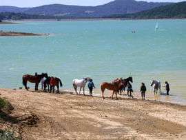
Horses at Montbel Lake | ||
| ||
 Montbel | ||
|
Location within Occitanie region  Montbel | ||
| Coordinates: 42°58′37″N 1°58′39″E / 42.9769°N 1.9775°ECoordinates: 42°58′37″N 1°58′39″E / 42.9769°N 1.9775°E | ||
| Country | France | |
| Region | Occitanie | |
| Department | Ariège | |
| Arrondissement | Pamiers | |
| Canton | Mirepoix | |
| Intercommunality | Pays de Mirepoix | |
| Government | ||
| • Mayor (2008–2014) | Pierre Terpant | |
| Area1 | 17.36 km2 (6.70 sq mi) | |
| Population (2008)2 | 109 | |
| • Density | 6.3/km2 (16/sq mi) | |
| Time zone | CET (UTC+1) | |
| • Summer (DST) | CEST (UTC+2) | |
| INSEE/Postal code | 09200 / 09600 | |
| Elevation |
345–587 m (1,132–1,926 ft) (avg. 410 m or 1,350 ft) | |
|
1 French Land Register data, which excludes lakes, ponds, glaciers > 1 km² (0.386 sq mi or 247 acres) and river estuaries. 2 Population without double counting: residents of multiple communes (e.g., students and military personnel) only counted once. | ||
.svg.png)
Montbel (Montbèl in Occitan) is a commune in the Ariège department in southwestern France.
Population
| Historical population | ||
|---|---|---|
| Year | Pop. | ±% |
| 1962 | 105 | — |
| 1968 | 113 | +7.6% |
| 1975 | 115 | +1.8% |
| 1982 | 110 | −4.3% |
| 1990 | 109 | −0.9% |
| 1999 | 123 | +12.8% |
| 2008 | 109 | −11.4% |
See also
References
| Wikimedia Commons has media related to Montbel, Ariège. |
This article is issued from Wikipedia - version of the 2/11/2016. The text is available under the Creative Commons Attribution/Share Alike but additional terms may apply for the media files.